

Model Development for Passive Microwave Remote Sensing ...
571
1 frequency [GHz)
1 6.8 110.65 118.7 1 23.8 1 36.5 1 90
pixel [km)
60
38
22
20 11.6 4.9
sampling interval [km)
15.5 15.5 15.5 15.5 7.75 3.87
radiometric sensitivity [OK) 0.2
0.4
0.5
0.5
0.5
0.7
radiometric stability [OK)
0.2
0.4
0.5
0.5
0.5
0.7
radiometric accuracy [OK)
1
1
1.5
1.5
1.5
1.5
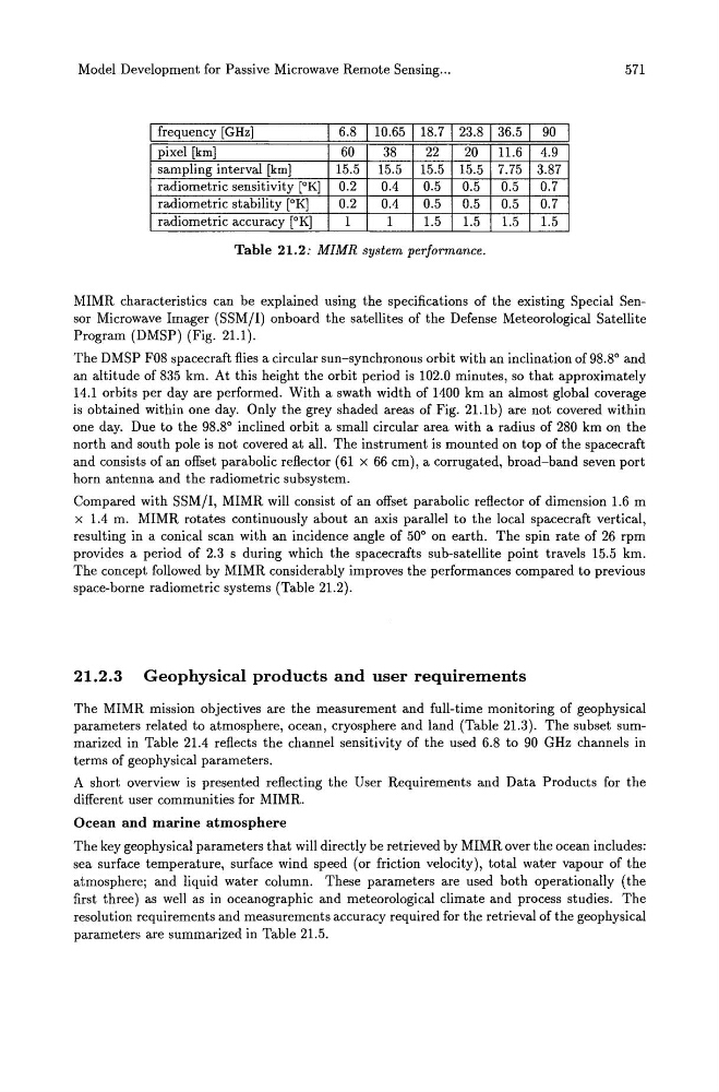
Table 21.2: MIMR system performance.
MIMR characteristics can be explained using the specifications of the existing Special Sensor Microwave Imager (SSM/I) onboard the satellites of the Defense Meteorological Satellite
Program (DMSP) (Fig. 21.1).
The DMSP F08 spacecraft flies a circular sun-synchronous orbit with an inclination of 98.8° and
an altitude of 835 km. At this height the orbit period is 102.0 minutes, so that approximately
14.1 orbits per day are performed. With a swath width of 1400 km an almost global coverage
is obtained within one day. Only the grey shaded areas of Fig. 21.1b) are not covered within
one day. Due to the 98.8° inclined orbit a small circular area with a radius of 280 km on the
north and south pole is not covered at all. The instrument is mounted on top of the spacecraft
and consists of an offset parabolic reflector (61 x 66 cm), a corrugated, broad-band seven port
horn antenna and the radiometric subsystem.
Compared with SSM/I, MIMR will consist of an offset parabolic reflector of dimension 1.6 m
x 1.4 m. MIMR rotates continuously about an axis parallel to the local spacecraft vertical,
resulting in a conical scan with an incidence angle of 50° on earth. The spin rate of 26 rpm
provides a period of 2.3 s during which the spacecrafts sub-satellite point travels 15.5 km.
The concept followed by MIMR considerably improves the performances compared to previous
space-borne radiometric systems (Table 21.2).
21.2.3 Geophysical products and user requirements
The MIMR mission objectives are the measurement and full-time monitoring of geophysical
parameters related to atmosphere, ocean, cryosphere and land (Table 21.3). The subset summarized in Table 21.4 reflects the channel sensitivity of the used 6.8 to 90 GHz channels in
terms of geophysical parameters.
A short overview is presented reflecting the User Requirements and Data Products for the
different user communities for MIMR.
Ocean and marine atmosphere
The key geophysical parameters that will directly be retrieved by MIMR over the ocean includes:
sea surface temperature, surface wind speed (or friction velocity), total water vapour of the
atmosphere; and liquid water column. These parameters are used both operationally (the
first three) as well as in oceanographic and meteorological climate and process studies. The
resolution requirements and measurements accuracy required for the retrieval of the geophysical
parameters are summarized in Table 21.5.