

540
M. Hallikainen
= 4.29
SD
The comparison suggests that local variations (land-cover category, forest canopies, terrain
relief) need to be accounted for when water equivalent algorithms are used. A digital land
use map and a digital elevation model are relevant tools for future algorithm development.
Another method is to use "anchor stations" to correct for errors produced by the varying
snow surface properties. The anchor stations have tower-based radiometers having identical
technical parameters (frequency, polarization, incidence angle) as the spaceborne radiometers,
and, additionally, the water equivalent is measured manually over a snow course (2 to 3 km
long path with varying land use categories).
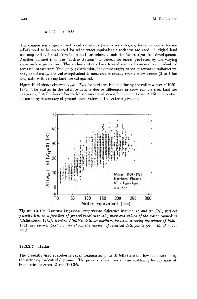
Figure 19.10 shows observed T18V - T37V for northern Finland during the entire winter of 19801981. The scatter in the satellite data is due to differences in snow particle size, land use
categories, distribution of forested/open areas and atmospheric conditions. Additional scatter
is caused by inaccuracy of ground-based values of the water equivalent.
50 .---~--~----~---~----~---r,
40
o 30
II
a
...
~ 20
.....
Winter 1980 - 1981
Northern Finland
llT : TlIv - T17V
N: 1522
-s ~--~----~--~----~--~----~
o SO 100 150 200 250 300
Water Equivalent (mm)
Figure 19.10: Observed brightness temperature difference between 18 and 37 GHz, vertical
polarization, as a function of ground-based manually measured values of the water equivalent
(Hallikainen, 1989). Nimbus-7 SMMR data for northern Finland, covering the winter of 19801981, are shown. Each number shows the number of identical data points (A == 10, B == 11,
etc.).
19.3.2.2 Radar
The presently used spaceborne radar frequencies (1 to 10 GHz) are too low for determining
the water equivalent of dry snow. The process is based on volume scattering by dry snow at
frequencies between 18 and 90 GHz.