

416
W.G.M. Bastiaanssen
Land use type
A
B
C
D
E
Regional
Parameter
(A to E aggregated)
T~JJ (OC)
23.6
29.7
35.0
42.8
46.8
30.3
ro (-)
0.17
0.17
0.20
0.35
0.23
0.22
NDVI (-)
0.71
0.24
0.41
0.17
0.18
0.34
fa (-)
0.99
0.94
0.97
0.93
0.93
0.97
ZOrn (m)
1.2 10- 1 5.910- 3 1.8 10- 2 3.810- 3 4.110- 3
0.011
8Ta(10) (OC)
1.8
6.0
9.9
15.6
18.3
7.0
u. (m s-l)
0.35
0.24
0.27
0.23
0.23
0.27
Ta(10) (0C)
21.8
23.7
25.1
27.2
28.5
23.3
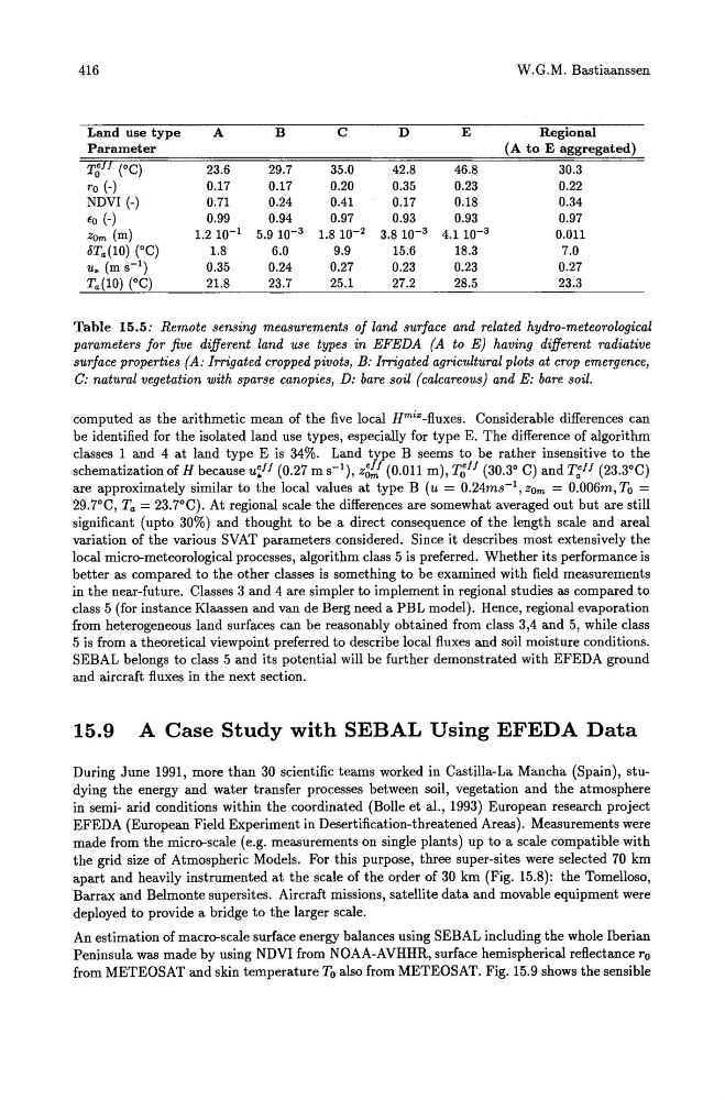
Table 15.5: Remote sensing measurements of land surface and related hydro-meteorological
parameters for five different land use types in EFEDA (A to E) having different radiative
surface properties (A: Irrigated cropped pivots, B: Irrigated agricultural plots at crop emergence,
C: natural vegetation with sparse canopies, D: bare soil (calcareous) and E: bare soil.
computed as the arithmetic mean of the five local Hmi"-fluxes. Considerable differences can
be identified for the isolated land use types, especially for type E. The difference of algorithm
classes 1 and 4 at land type E is 34%. Land type B seems to be rather insensitive to the
schematization of H because u:ff (0.27 m S-I), z~f! (0.011 m), T~ff (30.3° C) and T:ff (23.3°C)
are approximately similar to the local values at type B (u = 0.24ms- l , ZOm = 0.006m, To =
29.7°C, Ta = 23.7°C). At regional scale the differences are somewhat averaged out but are still
significant (upto 30%) and thought to be a direct consequence of the length scale and areal
variation of the various SVAT parameters considered. Since it describes most extensively the
local micro-meteorological processes, algorithm class 5 is preferred. Whether its performance is
better as compared to the other classes is something to be examined with field measurements
in the near-future. Classes 3 and 4 are simpler to implement in regional studies as compared to
class 5 (for instance Klaassen and van de Berg need a PBL model). Hence, regional evaporation
from heterogeneous land surfaces can be reasonably obtained from class 3,4 and 5, while class
5 is from a theoretical viewpoint preferred to describe local fluxes and soil moisture conditions.
SEBAL belongs to class 5 and its potential will be further demonstrated with EFEDA ground
and aircraft fluxes in the next section.
15.9 A Case Study with SEBAL Using EFEDA Data
During June 1991, more than 30 scientific teams worked in Castilla-La Mancha (Spain), studying the energy and water transfer processes between soil, vegetation and the atmosphere
in semi- arid conditions within the coordinated (Bolle et al., 1993) European research project
EFEDA (European Field Experiment in Desertification-threatened Areas). Measurements were
made from the micro-scale (e.g. measurements on single plants) up to a scale compatible with
the grid size of Atmospheric Models. For this purpose, three super-sites were selected 70 km
apart and heavily instrumented at the scale of the order of 30 km (Fig. 15.8): the Tomelloso,
Barrax and Belmonte supersites. Aircraft missions, satellite data and movable equipment were
deployed to provide a bridge to the larger scale.
An estimation of macro-scale surface energy balances using SEBAL including the whole Iberian
Peninsula was made by using NDVI from NOAA-AVHHR, surface hemispherical reflectance ro
from METEOSAT and skin temperature To also from METEOSAT. Fig. 15.9 shows the sensible
W.G.M. Bastiaanssen
Land use type
A
B
C
D
E
Regional
Parameter
(A to E aggregated)
T~JJ (OC)
23.6
29.7
35.0
42.8
46.8
30.3
ro (-)
0.17
0.17
0.20
0.35
0.23
0.22
NDVI (-)
0.71
0.24
0.41
0.17
0.18
0.34
fa (-)
0.99
0.94
0.97
0.93
0.93
0.97
ZOrn (m)
1.2 10- 1 5.910- 3 1.8 10- 2 3.810- 3 4.110- 3
0.011
8Ta(10) (OC)
1.8
6.0
9.9
15.6
18.3
7.0
u. (m s-l)
0.35
0.24
0.27
0.23
0.23
0.27
Ta(10) (0C)
21.8
23.7
25.1
27.2
28.5
23.3
Table 15.5: Remote sensing measurements of land surface and related hydro-meteorological
parameters for five different land use types in EFEDA (A to E) having different radiative
surface properties (A: Irrigated cropped pivots, B: Irrigated agricultural plots at crop emergence,
C: natural vegetation with sparse canopies, D: bare soil (calcareous) and E: bare soil.
computed as the arithmetic mean of the five local Hmi"-fluxes. Considerable differences can
be identified for the isolated land use types, especially for type E. The difference of algorithm
classes 1 and 4 at land type E is 34%. Land type B seems to be rather insensitive to the
schematization of H because u:ff (0.27 m S-I), z~f! (0.011 m), T~ff (30.3° C) and T:ff (23.3°C)
are approximately similar to the local values at type B (u = 0.24ms- l , ZOm = 0.006m, To =
29.7°C, Ta = 23.7°C). At regional scale the differences are somewhat averaged out but are still
significant (upto 30%) and thought to be a direct consequence of the length scale and areal
variation of the various SVAT parameters considered. Since it describes most extensively the
local micro-meteorological processes, algorithm class 5 is preferred. Whether its performance is
better as compared to the other classes is something to be examined with field measurements
in the near-future. Classes 3 and 4 are simpler to implement in regional studies as compared to
class 5 (for instance Klaassen and van de Berg need a PBL model). Hence, regional evaporation
from heterogeneous land surfaces can be reasonably obtained from class 3,4 and 5, while class
5 is from a theoretical viewpoint preferred to describe local fluxes and soil moisture conditions.
SEBAL belongs to class 5 and its potential will be further demonstrated with EFEDA ground
and aircraft fluxes in the next section.
15.9 A Case Study with SEBAL Using EFEDA Data
During June 1991, more than 30 scientific teams worked in Castilla-La Mancha (Spain), studying the energy and water transfer processes between soil, vegetation and the atmosphere
in semi- arid conditions within the coordinated (Bolle et al., 1993) European research project
EFEDA (European Field Experiment in Desertification-threatened Areas). Measurements were
made from the micro-scale (e.g. measurements on single plants) up to a scale compatible with
the grid size of Atmospheric Models. For this purpose, three super-sites were selected 70 km
apart and heavily instrumented at the scale of the order of 30 km (Fig. 15.8): the Tomelloso,
Barrax and Belmonte supersites. Aircraft missions, satellite data and movable equipment were
deployed to provide a bridge to the larger scale.
An estimation of macro-scale surface energy balances using SEBAL including the whole Iberian
Peninsula was made by using NDVI from NOAA-AVHHR, surface hemispherical reflectance ro
from METEOSAT and skin temperature To also from METEOSAT. Fig. 15.9 shows the sensible