

Remote Sensing of Soil Moisture
395
nistration), DARA (German Space Agency) and ASI (Italian Space Agency). The experiment
is the next evolutionary step in NASA's Spaceborne Imaging Radar (SIR) program that began
with the Seasat Synthetic Aperture Radar (SAR) in 1978 and continues with SIR-A in 1981
and SIR-B in 1984. It is also a continuation of Germany's radar program which started with
Microwave Remote Sensing Experiment (MRSE) flown aboard the Shuttle on the first SPACELAB mission in 1983. The SIR-C/X-SAR Mission benefits from synergism with aircraft sensors
such as the JPL airborne SAR (AIRSAR) and the German Aerospace Establishment (DLR)
E-SAR. The SIR-C, carrying on board a multifrequency SAR at X- (VV polarization), C-, and
L-bands (fully polarimetric), was launched in April and in October 1994. This multifrequency,
multipolarization capability can provide information about the Earth's surface over a wide
range of scales for studying many land and ocean processes. Six research areas have been emphasized by this project: Ecology, Geology, Hydrology, Oceanography, Calibration/Validation
Techniques and EM Theory. For each research area at least one supersite was selected among
the other test sites, in order to concentrate the efforts of several groups on the same area and
obtain as many data takes as possible on few sites. Montespertoli was the European test-site for
Hydrology and 10 data takes were collected over it during the ten days of the mission, both in
April and October. Ground truth measurements of soil, vegetation and meteo parameters were
collected during the SIR-C passages. The objective of this experiment was mainly to analyze
the radar response to many biophysical parameters, such as soil moisture, vegetation biomass,
surface roughness and so on and test theoretical models for microwave propagation over natural
surfaces. Till now only the data collected in April are available and researchers are working to
analyze them and carry out the first results. An empirical algorithm for the retrieval of soil
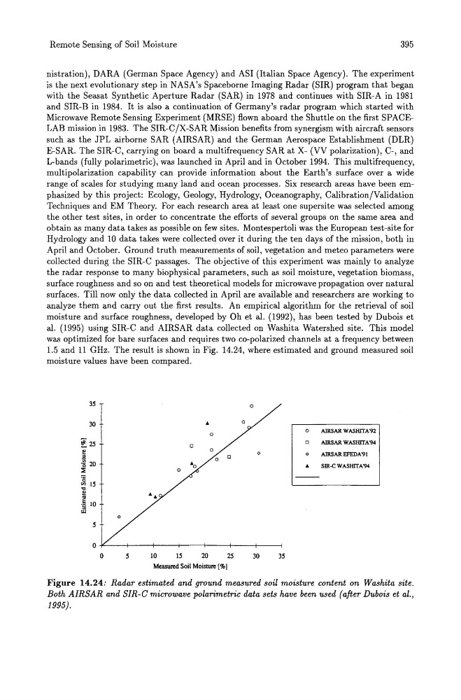
moisture and surface roughness, developed by Oh et al. (1992), has been tested by Dubois et
al. (1995) using SIR-C and AIRSAR data collected on Washita Watershed site. This model
was optimized for bare surfaces and requires two co-polarized channels at a frequency between
1.5 and 11 GHz. The result is shown in Fig. 14.24, where estimated and ground measured soil
moisture values have been compared.
35
0
30
..
0
0
0
AIRSAR WASIIITA·92
~25
0
0
AIRSAR WASIIITN94
e
a
·s 20
:.
0
0
0
0
AlRSAR EFEDA"91
0
.. SlR·C WASIIITA"94
·0
en 15
il
.~ 10
.rl
0
5
0
0
5
10
15
20
25
30
35
Measured Soil Moisture [%1
Figure 14.24: Radar estimated and ground measured soil moisture content on Washita site.
Both AIRSAR and SIR-C microwave polarimetric data sets have been used (after Dubois et al.,
1995).
395
nistration), DARA (German Space Agency) and ASI (Italian Space Agency). The experiment
is the next evolutionary step in NASA's Spaceborne Imaging Radar (SIR) program that began
with the Seasat Synthetic Aperture Radar (SAR) in 1978 and continues with SIR-A in 1981
and SIR-B in 1984. It is also a continuation of Germany's radar program which started with
Microwave Remote Sensing Experiment (MRSE) flown aboard the Shuttle on the first SPACELAB mission in 1983. The SIR-C/X-SAR Mission benefits from synergism with aircraft sensors
such as the JPL airborne SAR (AIRSAR) and the German Aerospace Establishment (DLR)
E-SAR. The SIR-C, carrying on board a multifrequency SAR at X- (VV polarization), C-, and
L-bands (fully polarimetric), was launched in April and in October 1994. This multifrequency,
multipolarization capability can provide information about the Earth's surface over a wide
range of scales for studying many land and ocean processes. Six research areas have been emphasized by this project: Ecology, Geology, Hydrology, Oceanography, Calibration/Validation
Techniques and EM Theory. For each research area at least one supersite was selected among
the other test sites, in order to concentrate the efforts of several groups on the same area and
obtain as many data takes as possible on few sites. Montespertoli was the European test-site for
Hydrology and 10 data takes were collected over it during the ten days of the mission, both in
April and October. Ground truth measurements of soil, vegetation and meteo parameters were
collected during the SIR-C passages. The objective of this experiment was mainly to analyze
the radar response to many biophysical parameters, such as soil moisture, vegetation biomass,
surface roughness and so on and test theoretical models for microwave propagation over natural
surfaces. Till now only the data collected in April are available and researchers are working to
analyze them and carry out the first results. An empirical algorithm for the retrieval of soil
moisture and surface roughness, developed by Oh et al. (1992), has been tested by Dubois et
al. (1995) using SIR-C and AIRSAR data collected on Washita Watershed site. This model
was optimized for bare surfaces and requires two co-polarized channels at a frequency between
1.5 and 11 GHz. The result is shown in Fig. 14.24, where estimated and ground measured soil
moisture values have been compared.
35
0
30
..
0
0
0
AIRSAR WASIIITA·92
~25
0
0
AIRSAR WASIIITN94
e
a
·s 20
:.
0
0
0
0
AlRSAR EFEDA"91
0
.. SlR·C WASIIITA"94
·0
en 15
il
.~ 10
.rl
0
5
0
0
5
10
15
20
25
30
35
Measured Soil Moisture [%1
Figure 14.24: Radar estimated and ground measured soil moisture content on Washita site.
Both AIRSAR and SIR-C microwave polarimetric data sets have been used (after Dubois et al.,
1995).