

22
E. Raschke
in size than the beam of sensors in space, which at present amount to about 30 km. Further
details are described by Simmer (this volume).
Since at present such observations are made only from one single polar orbiting satellite, such
precipitation values contain larger sampling errors. The Global Precipitation Data Center
(GPDC) of the WCRP collects all such data and merges them with continental based gauge
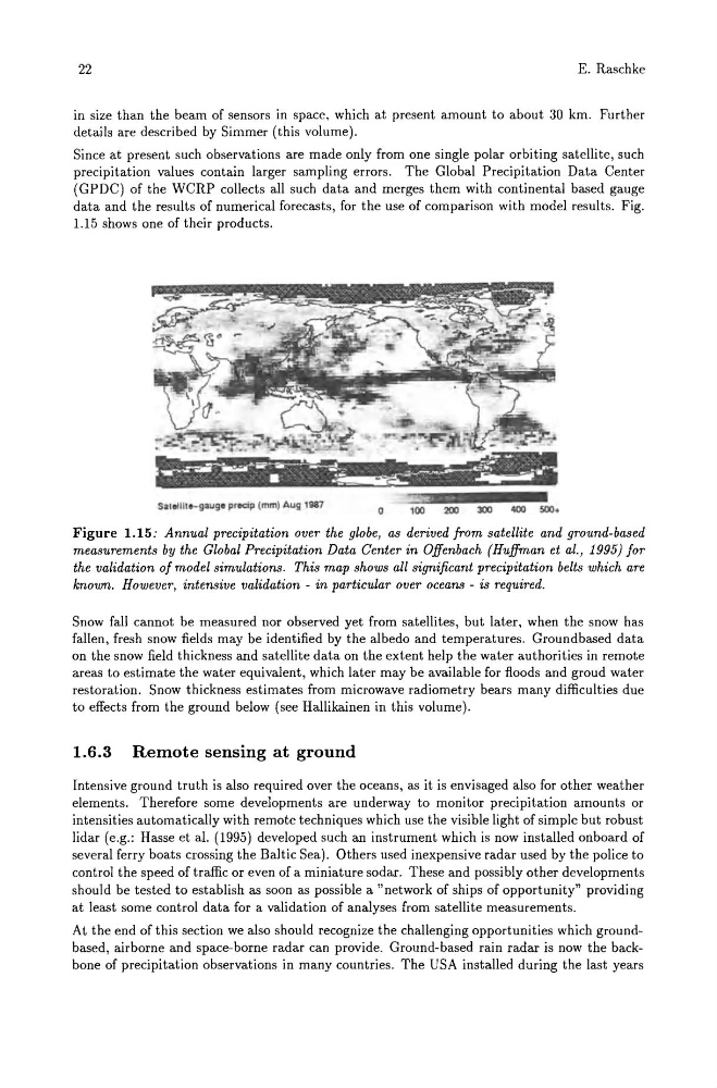
data and the results of numerical forecasts, for the use of comparison with model results. Fig.
1.15 shows one of their products.
Sat.Ullo-gaug. proocip (mml Aug 1987 1iiO=>_:03::~l~OO;:200;:300;iii~400i:;500~.
Figure 1.15: Annual precipitation over the globe, as derived from satellite and ground-based
measurements by the Global Precipitation Data Center in Offenbach (Huffman et al., 1995) for
the validation of model simulations. This map shows all significant precipitation belts which are
known. However, intensive validation - in particular over oceans - is required.
Snow fall cannot be measured nor observed yet from satellites, but later, when the snow has
fallen, fresh snow fields may be identified by the albedo and temperatures. Groundbased data
on the snow field thickness and satellite data on the extent help the water authorities in remote
areas to estimate the water equivalent, which later may be available for floods and groud water
restoration. Snow thickness estimates from microwave radiometry bears many difficulties due
to effects from the ground below (see Hallikainen in this volume).
1.6.3 Remote sensing at ground
Intensive ground truth is also required over the oceans, as it is envisaged also for other weather
elements. Therefore some developments are underway to monitor precipitation amounts or
intensities automatically with remote techniques which use the visible light of simple but robust
lidar (e.g.: Hasse et al. (1995) developed such an instrument which is now installed onboard of
several ferry boats crossing the Baltic Sea). Others used inexpensive radar used by the police to
control the speed of traffic or even of a miniature sodaro These and possibly other developments
should be tested to establish as soon as possible a "network of ships of opportunity" providing
at least some control data for a validation of analyses from satellite measurements.
At the end of this section we also should recognize the challenging opportunities which groundbased, airborne and space-borne radar can provide. Ground-based rain radar is now the backbone of precipitation observations in many countries. The USA installed during the last years
E. Raschke
in size than the beam of sensors in space, which at present amount to about 30 km. Further
details are described by Simmer (this volume).
Since at present such observations are made only from one single polar orbiting satellite, such
precipitation values contain larger sampling errors. The Global Precipitation Data Center
(GPDC) of the WCRP collects all such data and merges them with continental based gauge
data and the results of numerical forecasts, for the use of comparison with model results. Fig.
1.15 shows one of their products.
Sat.Ullo-gaug. proocip (mml Aug 1987 1iiO=>_:03::~l~OO;:200;:300;iii~400i:;500~.
Figure 1.15: Annual precipitation over the globe, as derived from satellite and ground-based
measurements by the Global Precipitation Data Center in Offenbach (Huffman et al., 1995) for
the validation of model simulations. This map shows all significant precipitation belts which are
known. However, intensive validation - in particular over oceans - is required.
Snow fall cannot be measured nor observed yet from satellites, but later, when the snow has
fallen, fresh snow fields may be identified by the albedo and temperatures. Groundbased data
on the snow field thickness and satellite data on the extent help the water authorities in remote
areas to estimate the water equivalent, which later may be available for floods and groud water
restoration. Snow thickness estimates from microwave radiometry bears many difficulties due
to effects from the ground below (see Hallikainen in this volume).
1.6.3 Remote sensing at ground
Intensive ground truth is also required over the oceans, as it is envisaged also for other weather
elements. Therefore some developments are underway to monitor precipitation amounts or
intensities automatically with remote techniques which use the visible light of simple but robust
lidar (e.g.: Hasse et al. (1995) developed such an instrument which is now installed onboard of
several ferry boats crossing the Baltic Sea). Others used inexpensive radar used by the police to
control the speed of traffic or even of a miniature sodaro These and possibly other developments
should be tested to establish as soon as possible a "network of ships of opportunity" providing
at least some control data for a validation of analyses from satellite measurements.
At the end of this section we also should recognize the challenging opportunities which groundbased, airborne and space-borne radar can provide. Ground-based rain radar is now the backbone of precipitation observations in many countries. The USA installed during the last years