

Precipitation at the Ground: Radar Techniques
295
12.5.3 Surveillance of synoptic and mesoscale systems
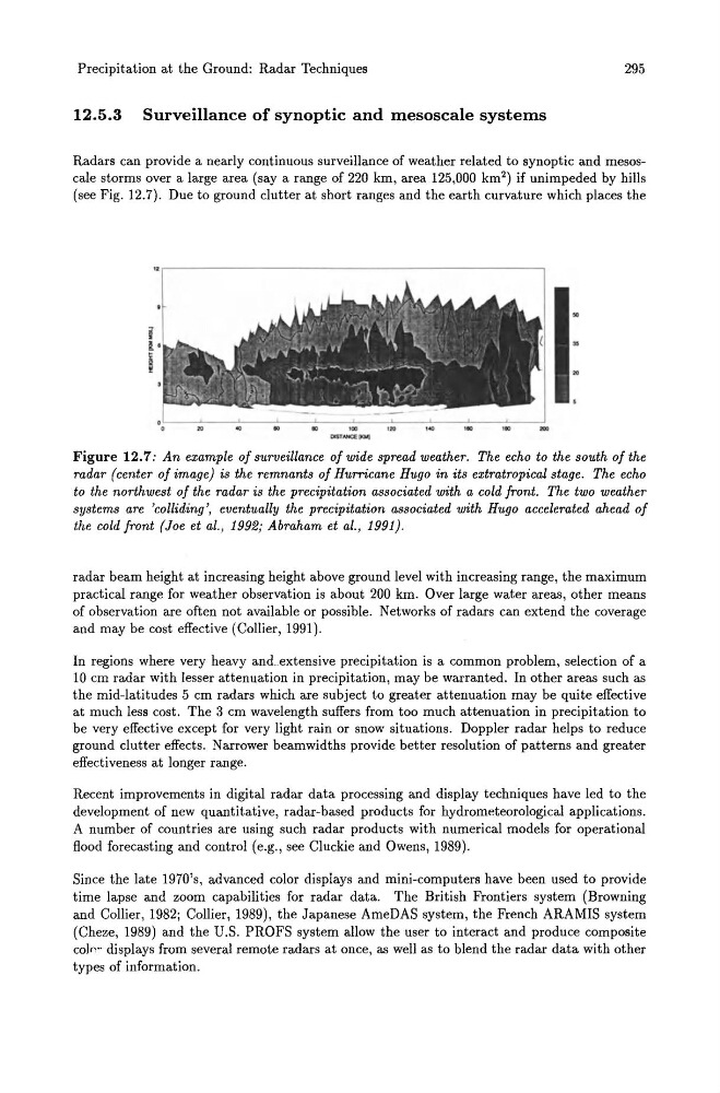
Radars can provide a nearly continuous surveillance of weather related to synoptic and mesoscale storms over a large area (say a range of 220 km, area 125,000 km 2 ) if unimpeded by hills
(see Fig. 12.7). Due to ground clutter at short ranges and the earth curvature which places the
Figure 12.7: An example of surveillance of wide spread weather. The echo to the south of the
radar (center of image) is the remnants of Hurricane Hugo in its extratropical stage. The echo
to the northwest of the radar is the precipitation associated with a cold front. The two weather
systems are 'colliding', eventually the precipitation associated with Hugo accelerated ahead of
the cold front (Joe et at. , 1992; Abraham et al., 1991).
radar beam height at increasing height above ground level with increasing range, the maximum
practical range for weather observation is about 200 km. Over large water areas, other means
of observation are often not available or possible. Networks of radars can extend the coverage
and may be cost effective (Collier, 1991) .
In regions where very heavy and_.extensive precipitation is a common problem, selection of a
10 cm radar with lesser attenuation in precipitation, may be warranted. In other areas such as
the mid-latitudes 5 cm radars which are subject to greater attenuation may be quite effective
at much less cost. The 3 cm wavelength suffers from too much attenuation in precipitation to
be very effective except for very light rain or snow situations. Doppler radar helps to reduce
ground clutter effects. Narrower beamwidths provide better resolution of patterns and greater
effectiveness at longer range.
Recent improvements in digital radar data processing and display techniques have led to the
development of new quantitative, radar-based products for hydrometeorological applications.
A number of countries are using such radar products with numerical models for operational
flood forecasting and control (e.g., see Cluckie and Owens, 1989).
Since the late 1970's, advanced color displays and mini-computers have been used to provide
time lapse and zoom capabilities for radar data. The British Frontiers system (Browning
and Collier, 1982; Collier, 1989), the Japanese AmeDAS system, the French ARAMIS system
(Cheze, 1989) and the U.S. PROFS system allow the user to interact and produce composite
co]cw displays from several remote radars at once, as well as to blend the radar data with other
types of information.
295
12.5.3 Surveillance of synoptic and mesoscale systems
Radars can provide a nearly continuous surveillance of weather related to synoptic and mesoscale storms over a large area (say a range of 220 km, area 125,000 km 2 ) if unimpeded by hills
(see Fig. 12.7). Due to ground clutter at short ranges and the earth curvature which places the
Figure 12.7: An example of surveillance of wide spread weather. The echo to the south of the
radar (center of image) is the remnants of Hurricane Hugo in its extratropical stage. The echo
to the northwest of the radar is the precipitation associated with a cold front. The two weather
systems are 'colliding', eventually the precipitation associated with Hugo accelerated ahead of
the cold front (Joe et at. , 1992; Abraham et al., 1991).
radar beam height at increasing height above ground level with increasing range, the maximum
practical range for weather observation is about 200 km. Over large water areas, other means
of observation are often not available or possible. Networks of radars can extend the coverage
and may be cost effective (Collier, 1991) .
In regions where very heavy and_.extensive precipitation is a common problem, selection of a
10 cm radar with lesser attenuation in precipitation, may be warranted. In other areas such as
the mid-latitudes 5 cm radars which are subject to greater attenuation may be quite effective
at much less cost. The 3 cm wavelength suffers from too much attenuation in precipitation to
be very effective except for very light rain or snow situations. Doppler radar helps to reduce
ground clutter effects. Narrower beamwidths provide better resolution of patterns and greater
effectiveness at longer range.
Recent improvements in digital radar data processing and display techniques have led to the
development of new quantitative, radar-based products for hydrometeorological applications.
A number of countries are using such radar products with numerical models for operational
flood forecasting and control (e.g., see Cluckie and Owens, 1989).
Since the late 1970's, advanced color displays and mini-computers have been used to provide
time lapse and zoom capabilities for radar data. The British Frontiers system (Browning
and Collier, 1982; Collier, 1989), the Japanese AmeDAS system, the French ARAMIS system
(Cheze, 1989) and the U.S. PROFS system allow the user to interact and produce composite
co]cw displays from several remote radars at once, as well as to blend the radar data with other
types of information.