

294
100 . - - - - - - -- ,
eo
-20
~
L -_ _ _ _ _ _ ~ _ _ _ ~ _ _ ~
-eo
~
WEST-EAST [KM[
-20
P. Joe
••
2.
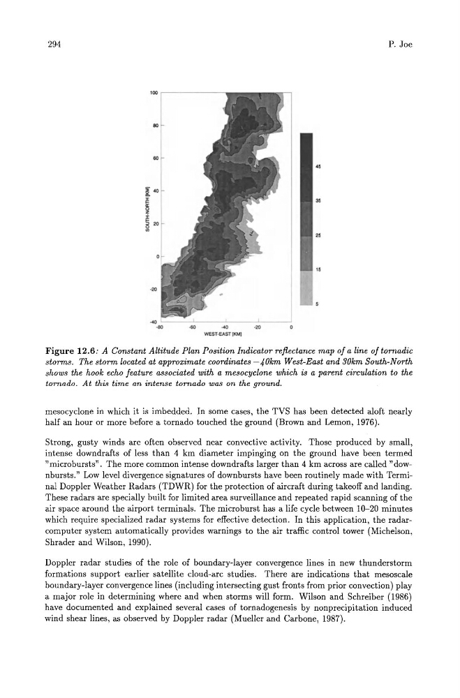
Figure 12.6: A Constant Altitude Plan Position Indicator reflectance map of a line of tornadic
storms. The storm located at approximate coordinates -40km West-East and 30km South-North
shows the hook echo feature associated with a mesocycione which is a parent circulation to the
tornado. At this time an intense tornado was on the ground.
meso cyclone in which it is imbedded. In some cases, the TVS has been detected aloft nearly
half an hour or more before a tornado touched the ground (Brown and Lemon, 1976).
Strong, gusty winds are often observed near convective activity. Those produced by small,
intense downdrafts of less than 4 km diameter impinging on the ground have been termed
"microbursts". The more common intense downdrafts larger than 4 km across are called "downbursts." Low level divergence signatures of downbursts have been routinely made with Terminal Doppler Weather Radars (TDWR) for the protection of aircraft during takeoff and landing.
These radars are specially built for limited area surveillance and repeated rapid scanning of the
air space around the airport terminals. The microburst has a life cycle between 10-20 minutes
which require specialized radar systems for effective detection. In this application, the radarcomputer system automatically provides warnings to the air traffic control tower (Michelson,
Shrader and Wilson, 1990).
Doppler radar studies of the role of boundary-layer convergence lines in new thunderstorm
formations support earlier satellite cloud-arc studies. There are indications that mesoscale
boundary-layer convergence lines (including intersecting gust fronts from prior convection) play
a major role in determining where and when storms will form. Wilson and Schreiber (1986)
have documented and explained several cases of tornadogenesis by nonprecipitation induced
wind shear lines, as observed by Doppler radar (Mueller and Carbone, 1987).
100 . - - - - - - -- ,
eo
-20
~
L -_ _ _ _ _ _ ~ _ _ _ ~ _ _ ~
-eo
~
WEST-EAST [KM[
-20
P. Joe
••
2.
Figure 12.6: A Constant Altitude Plan Position Indicator reflectance map of a line of tornadic
storms. The storm located at approximate coordinates -40km West-East and 30km South-North
shows the hook echo feature associated with a mesocycione which is a parent circulation to the
tornado. At this time an intense tornado was on the ground.
meso cyclone in which it is imbedded. In some cases, the TVS has been detected aloft nearly
half an hour or more before a tornado touched the ground (Brown and Lemon, 1976).
Strong, gusty winds are often observed near convective activity. Those produced by small,
intense downdrafts of less than 4 km diameter impinging on the ground have been termed
"microbursts". The more common intense downdrafts larger than 4 km across are called "downbursts." Low level divergence signatures of downbursts have been routinely made with Terminal Doppler Weather Radars (TDWR) for the protection of aircraft during takeoff and landing.
These radars are specially built for limited area surveillance and repeated rapid scanning of the
air space around the airport terminals. The microburst has a life cycle between 10-20 minutes
which require specialized radar systems for effective detection. In this application, the radarcomputer system automatically provides warnings to the air traffic control tower (Michelson,
Shrader and Wilson, 1990).
Doppler radar studies of the role of boundary-layer convergence lines in new thunderstorm
formations support earlier satellite cloud-arc studies. There are indications that mesoscale
boundary-layer convergence lines (including intersecting gust fronts from prior convection) play
a major role in determining where and when storms will form. Wilson and Schreiber (1986)
have documented and explained several cases of tornadogenesis by nonprecipitation induced
wind shear lines, as observed by Doppler radar (Mueller and Carbone, 1987).