

206
W.B. Rossow
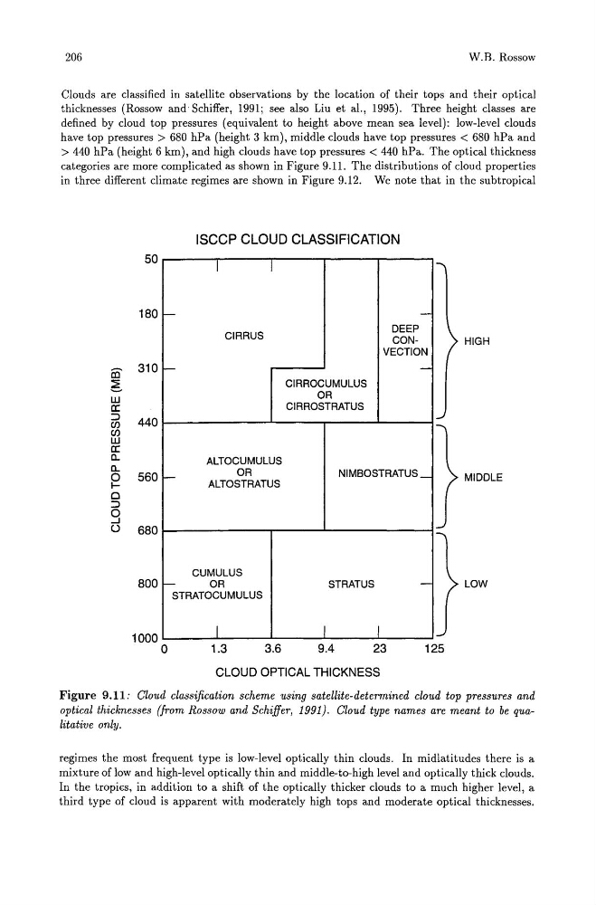
Clouds are classified in satellite observations by the location of their tops and their optical
thicknesses (Rossow and Schiffer, 1991; see also Liu et al., 1995). Three height classes are
defined by cloud top pressures (equivalent to height above mean sea level): low-level clouds
have top pressures> 680 hPa (height 3 km), middle clouds have top pressures < 680 hPa and
> 440 hPa (height 6 km), and high clouds have top pressures < 440 hPa. The optical thickness
categories are more complicated as shown in Figure 9.11. The distributions of cloud properties
in three different climate regimes are shown in Figure 9.12. We note that in the subtropical
ISCCP CLOUD CLASSIFICATION
50
I
I
....,
180 -
-
CIRRUS
DEEP
CONHIGH
VECTION
m 310 -
-
CIRROCUMULUS
OR
CIRROSTRATUS
6
w
a::
~
::::>
440
C/)
C/)
w
a::
c..
ALTOCUMULUS
-
OR
NIMBOSTRATUS _
ALTOSTRATUS
c..
0
560
IMIDDLE
0
::::>
0
=<
-.J
()
680
CUMULUS
800 -
OR
STRATUS
-
LOW
STRATOCUMULUS
1000
I
I
I
'--/
o
1.3
3.6
9.4
23
125
CLOUD OPTICAL THICKNESS
Figure 9.11: Cloud classification scheme using satellite-determined cloud top pressures and
optical thicknesses (from Rossow and Schiffer, 1991). Cloud type names are meant to be qualitative only.
regimes the most frequent type is low-level optically thin clouds. In midlatitudes there is a
mixture of low and high-level optically thin and middle-to-high level and optically thick clouds.
In the tropics, in addition to a shift of the optically thicker clouds to a much higher level, a
third type of cloud is apparent with moderately high tops and moderate optical thicknesses.
W.B. Rossow
Clouds are classified in satellite observations by the location of their tops and their optical
thicknesses (Rossow and Schiffer, 1991; see also Liu et al., 1995). Three height classes are
defined by cloud top pressures (equivalent to height above mean sea level): low-level clouds
have top pressures> 680 hPa (height 3 km), middle clouds have top pressures < 680 hPa and
> 440 hPa (height 6 km), and high clouds have top pressures < 440 hPa. The optical thickness
categories are more complicated as shown in Figure 9.11. The distributions of cloud properties
in three different climate regimes are shown in Figure 9.12. We note that in the subtropical
ISCCP CLOUD CLASSIFICATION
50
I
I
....,
180 -
-
CIRRUS
DEEP
CONHIGH
VECTION
m 310 -
-
CIRROCUMULUS
OR
CIRROSTRATUS
6
w
a::
~
::::>
440
C/)
C/)
w
a::
c..
ALTOCUMULUS
-
OR
NIMBOSTRATUS _
ALTOSTRATUS
c..
0
560
IMIDDLE
0
::::>
0
=<
-.J
()
680
CUMULUS
800 -
OR
STRATUS
-
LOW
STRATOCUMULUS
1000
I
I
I
'--/
o
1.3
3.6
9.4
23
125
CLOUD OPTICAL THICKNESS
Figure 9.11: Cloud classification scheme using satellite-determined cloud top pressures and
optical thicknesses (from Rossow and Schiffer, 1991). Cloud type names are meant to be qualitative only.
regimes the most frequent type is low-level optically thin clouds. In midlatitudes there is a
mixture of low and high-level optically thin and middle-to-high level and optically thick clouds.
In the tropics, in addition to a shift of the optically thicker clouds to a much higher level, a
third type of cloud is apparent with moderately high tops and moderate optical thicknesses.