

204
,...
M
v
... c:
" 0
~
"0
" 0
U
,...
M
v
... c:
" 0
~
"0
" 0
U
40
30
20
10
C2 Regional Means by Local Time
Northern Hemisphere 0-60N Lend Only
1989
Wi nter
Sp r-I n<;l
~2
~:~~-::::::::::-~
~' . ~ • . ~. : ;~; :~~~:;:
~~~~~{" -::::::~2
·!M~:. :, )i/~:~:=:=:~2
~ .. :' f~i
~/
W.B. Rossow
30
20
10
o
0
270
27~
280
28~
290
295 27~ 280 28~ 290 29~ 300 30~ 3 I 0
40
Summer
Fa l I
30
:30
20
10
008<. . . -----}2
~~~::~S~~~2
- ·-;.,.t.!.'_ ._"2
"" I.f'
20
10
0410'
o
0
285
290
295
:300 305 :310 315 275 280 285 290 295 :300 30~ 3 10
Temperature (K)
Temperature (K)
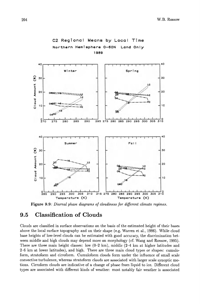
Figure 9.9: Diurnal phase diagrams of cloudiness for different climate regimes,
9.5 Classification of Clouds
Clouds are classified in surface observations on the basis of the estimated height of their bases
above the local surface topography and on their shape (e.g. Warren et al., 1986). While cloud
base heights of low-level clouds can be estimated with good accuracy, the discrimination between middle and high clouds may depend more on morphology (cf. Wang and Rossow, 1995).
There are three main height classes: low (0-2 km), middle (2-4 km at higher latitudes and
2-6 km at lower latitudes), and high. There are three main cloud types or shapes: cumuloform, stratoform and cirroform. Cumuloform clouds form under the influence of small scale
convective turbulence, whereas stratoform clouds are associated with larger scale synoptic motions. Cirroform clouds are indicative of a change of phase from liquid to ice. Different cloud
types are associated with different kinds of weather: most notably fair weather is associated
,...
M
v
... c:
" 0
~
"0
" 0
U
,...
M
v
... c:
" 0
~
"0
" 0
U
40
30
20
10
C2 Regional Means by Local Time
Northern Hemisphere 0-60N Lend Only
1989
Wi nter
Sp r-I n<;l
~2
~:~~-::::::::::-~
~' . ~ • . ~. : ;~; :~~~:;:
~~~~~{" -::::::~2
·!M~:. :, )i/~:~:=:=:~2
~ .. :' f~i
~/
W.B. Rossow
30
20
10
o
0
270
27~
280
28~
290
295 27~ 280 28~ 290 29~ 300 30~ 3 I 0
40
Summer
Fa l I
30
:30
20
10
008<. . . -----}2
~~~::~S~~~2
- ·-;.,.t.!.'_ ._"2
"" I.f'
20
10
0410'
o
0
285
290
295
:300 305 :310 315 275 280 285 290 295 :300 30~ 3 10
Temperature (K)
Temperature (K)
Figure 9.9: Diurnal phase diagrams of cloudiness for different climate regimes,
9.5 Classification of Clouds
Clouds are classified in surface observations on the basis of the estimated height of their bases
above the local surface topography and on their shape (e.g. Warren et al., 1986). While cloud
base heights of low-level clouds can be estimated with good accuracy, the discrimination between middle and high clouds may depend more on morphology (cf. Wang and Rossow, 1995).
There are three main height classes: low (0-2 km), middle (2-4 km at higher latitudes and
2-6 km at lower latitudes), and high. There are three main cloud types or shapes: cumuloform, stratoform and cirroform. Cumuloform clouds form under the influence of small scale
convective turbulence, whereas stratoform clouds are associated with larger scale synoptic motions. Cirroform clouds are indicative of a change of phase from liquid to ice. Different cloud
types are associated with different kinds of weather: most notably fair weather is associated