

Extratropical Cyclones: Their Mesoscale Structure, ...
131
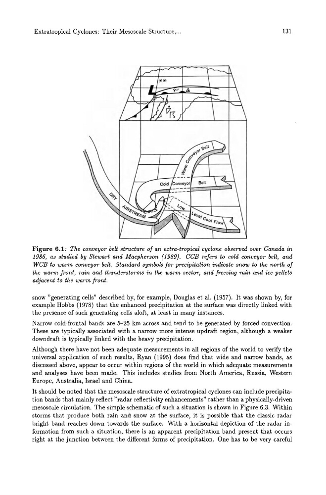
Figure 6.1: The conveyor belt structure of an extra-tropical cyclone observed over Canada in
1986, as studied by Stewart and Macpherson (1989). CCB refers to cold conveyor belt, and
WCB to warm conveyor belt. Standard symbols for precipitation indicate snow to the north of
the warm front, rain and thunderstorms in the warm sector, and freezing rain and ice pellets
adjacent to the warm front.
snow "generating cells" described by, for example, Douglas et al. (1957). It was shown by, for
example Hobbs (1978) that the enhanced precipitation at the surface was directly linked with
the presence of such generating cells aloft, at least in many instances.
Narrow cold-frontal bands are 5-25 km across and tend to be generated by forced convection.
These are typically associated with a narrow more intense updraft region, although a weaker
downdraft is typically linked with the heavy precipitation.
Although there have not been adequate measurements in all regions of the world to verify the
universal application of such results, Ryan (1995) does find that wide and narrow bands, as
discussed above, appear to occur within regions of the world in which adequate measurements
and analyses have been made. This includes studies from North America, Russia, Western
Europe, Australia, Israel and China.
It should be noted that the mesoscale structure of extratropical cyclones can include precipitation bands that mainly reflect "radar reflectivity enhancements" rather than a physically-driven
mesoscale circulation. The simple schematic of such a situation is shown in Figure 6.3. Within
storms that produce both rain and snow at the surface, it is possible that the classic radar
bright band reaches down towards the surface. With a horizontal depiction of the radar information from such a situation, there is an apparent precipitation band present that occurs
right at the junction between the different forms of precipitation. One has to be very careful
131
Figure 6.1: The conveyor belt structure of an extra-tropical cyclone observed over Canada in
1986, as studied by Stewart and Macpherson (1989). CCB refers to cold conveyor belt, and
WCB to warm conveyor belt. Standard symbols for precipitation indicate snow to the north of
the warm front, rain and thunderstorms in the warm sector, and freezing rain and ice pellets
adjacent to the warm front.
snow "generating cells" described by, for example, Douglas et al. (1957). It was shown by, for
example Hobbs (1978) that the enhanced precipitation at the surface was directly linked with
the presence of such generating cells aloft, at least in many instances.
Narrow cold-frontal bands are 5-25 km across and tend to be generated by forced convection.
These are typically associated with a narrow more intense updraft region, although a weaker
downdraft is typically linked with the heavy precipitation.
Although there have not been adequate measurements in all regions of the world to verify the
universal application of such results, Ryan (1995) does find that wide and narrow bands, as
discussed above, appear to occur within regions of the world in which adequate measurements
and analyses have been made. This includes studies from North America, Russia, Western
Europe, Australia, Israel and China.
It should be noted that the mesoscale structure of extratropical cyclones can include precipitation bands that mainly reflect "radar reflectivity enhancements" rather than a physically-driven
mesoscale circulation. The simple schematic of such a situation is shown in Figure 6.3. Within
storms that produce both rain and snow at the surface, it is possible that the classic radar
bright band reaches down towards the surface. With a horizontal depiction of the radar information from such a situation, there is an apparent precipitation band present that occurs
right at the junction between the different forms of precipitation. One has to be very careful