

In the absence of Jadigenahalli Gram Panchayat data, Hoskote Taluk data is used
here because Jadigenahalli Gram Panchayat comes under Hoskote Taluk and is
9 km off from Hoskote. From secondary data (see graph), it can be observed that the
area under maize (542–204 ha) and paddy (1762 to 566 ha) has drastically
decreased as compared to ragi (14,226–11,460 ha) mainly because of a shift in the
cropping pattern; as ragi is the staple food, instead of leaving the land fallow, many
are cultivating ragi under rainfed area.
Indicator 14: Area Under Irrigation
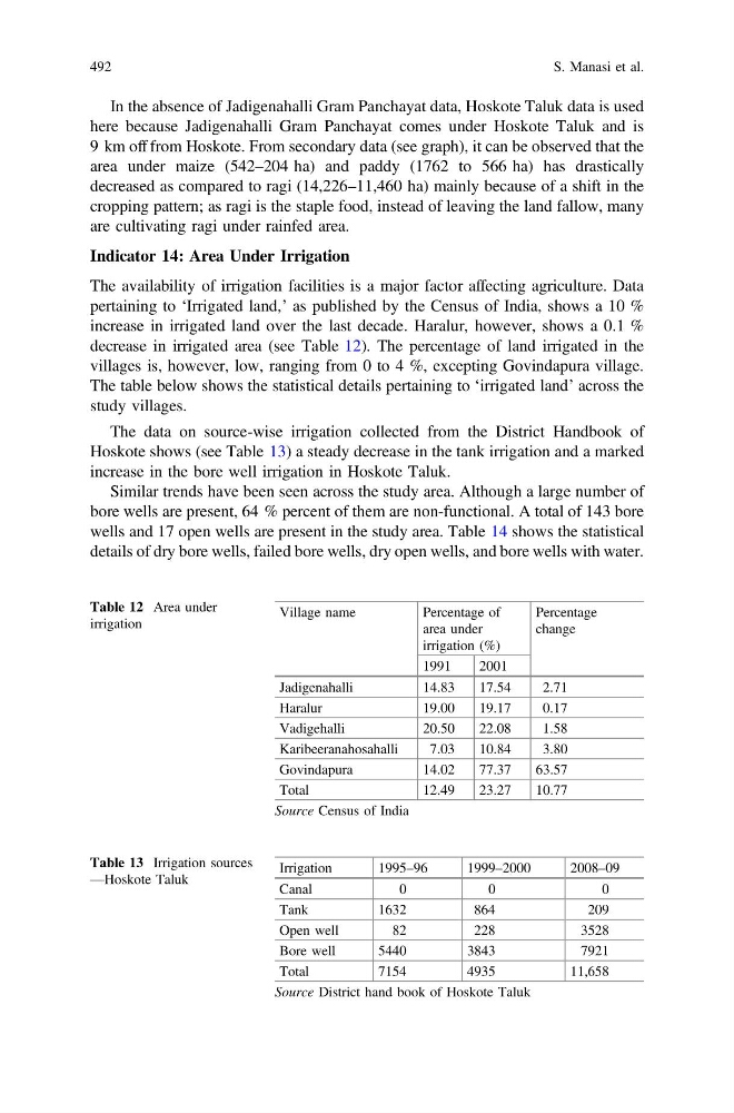
The availability of irrigation facilities is a major factor affecting agriculture. Data
pertaining to ‘Irrigated land,’ as published by the Census of India, shows a 10 %
increase in irrigated land over the last decade. Haralur, however, shows a 0.1 %
decrease in irrigated area (see Table 12). The percentage of land irrigated in the
villages is, however, low, ranging from 0 to 4 %, excepting Govindapura village.
The table below shows the statistical details pertaining to ‘irrigated land’ across the
study villages.
The data on source-wise irrigation collected from the District Handbook of
Hoskote shows (see Table 13) a steady decrease in the tank irrigation and a marked
increase in the bore well irrigation in Hoskote Taluk.
Similar trends have been seen across the study area. Although a large number of
bore wells are present, 64 % percent of them are non-functional. A total of 143 bore
wells and 17 open wells are present in the study area. Table 14 shows the statistical
details of dry bore wells, failed bore wells, dry open wells, and bore wells with water.
Table 12 Area under
irrigation
Village name
Percentage of
area under
irrigation (%)
Percentage
change
1991
2001
Jadigenahalli
14.83
17.54
2.71
Haralur
19.00
19.17
0.17
Vadigehalli
20.50
22.08
1.58
Karibeeranahosahalli
7.03
10.84
3.80
Govindapura
14.02
77.37
63.57
Total
12.49
23.27
10.77
Source Census of India
Table 13 Irrigation sources
—Hoskote Taluk
Irrigation
1995–96
1999–2000
2008–09
Canal
0
0
0
Tank
1632
864
209
Open well
82
228
3528
Bore well
5440
3843
7921
Total
7154
4935
11,658
Source District hand book of Hoskote Taluk
492
S. Manasi et al.
here because Jadigenahalli Gram Panchayat comes under Hoskote Taluk and is
9 km off from Hoskote. From secondary data (see graph), it can be observed that the
area under maize (542–204 ha) and paddy (1762 to 566 ha) has drastically
decreased as compared to ragi (14,226–11,460 ha) mainly because of a shift in the
cropping pattern; as ragi is the staple food, instead of leaving the land fallow, many
are cultivating ragi under rainfed area.
Indicator 14: Area Under Irrigation
The availability of irrigation facilities is a major factor affecting agriculture. Data
pertaining to ‘Irrigated land,’ as published by the Census of India, shows a 10 %
increase in irrigated land over the last decade. Haralur, however, shows a 0.1 %
decrease in irrigated area (see Table 12). The percentage of land irrigated in the
villages is, however, low, ranging from 0 to 4 %, excepting Govindapura village.
The table below shows the statistical details pertaining to ‘irrigated land’ across the
study villages.
The data on source-wise irrigation collected from the District Handbook of
Hoskote shows (see Table 13) a steady decrease in the tank irrigation and a marked
increase in the bore well irrigation in Hoskote Taluk.
Similar trends have been seen across the study area. Although a large number of
bore wells are present, 64 % percent of them are non-functional. A total of 143 bore
wells and 17 open wells are present in the study area. Table 14 shows the statistical
details of dry bore wells, failed bore wells, dry open wells, and bore wells with water.
Table 12 Area under
irrigation
Village name
Percentage of
area under
irrigation (%)
Percentage
change
1991
2001
Jadigenahalli
14.83
17.54
2.71
Haralur
19.00
19.17
0.17
Vadigehalli
20.50
22.08
1.58
Karibeeranahosahalli
7.03
10.84
3.80
Govindapura
14.02
77.37
63.57
Total
12.49
23.27
10.77
Source Census of India
Table 13 Irrigation sources
—Hoskote Taluk
Irrigation
1995–96
1999–2000
2008–09
Canal
0
0
0
Tank
1632
864
209
Open well
82
228
3528
Bore well
5440
3843
7921
Total
7154
4935
11,658
Source District hand book of Hoskote Taluk
492
S. Manasi et al.