

Spatial and Temporal Variations in Precipitation and Aridity Index Series of Turkey
185
~T~
•
flrtptW'M'
B .
0 In
Adry
iwo. . $:' IIolbn
~ O
0
. . . .
C..
U
IJ
I-I:-'-"'~ ,.
Kd ,~
,::-,---,:,;: ' ...
r ":I:""l""""""-w
fIT
07'
...
Geographical distribution
of stations
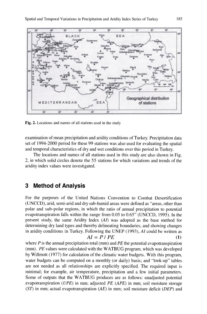
Fig. 2. Locations and names of all stations used in the study
examination of mean precipitation and aridity conditions of Turkey. Precipitation data
set of 1994-2000 period for these 99 stations was also used for evaluating the spatial
and temporal characteristics of dry and wet conditions over this period in Turkey.
The locations and names of all stations used in this study are also shown in Fig.
2, in which solid circles denote the 55 stations for which variations and trends of the
aridity index values were investigated.
3 Method of Analysis
For the purposes of the United Nations Convention to Combat Desertification
(UNCCD), arid, semi-arid and dry sub-humid areas were defined as "areas, other than
polar and sub-polar regions, in which the ratio of annual precipitation to potential
evapotranspiration falls within the range from 0.05 to 0.65" (UNCCD, 1995). In the
present study, the same Aridity Index (Al) was adopted as the base method for
determining dry land types and thereby delineating boundaries, and showing changes
in aridity conditions in Turkey. Following the UNEP (1993), AI could be written as
AI = P / PE
(1)
where P is the annual precipitation total (mm) and PE the potential evapotranspiration
(mm). PE values were calculated with the WATBUG program, which was developed
by Willmott (1977) for calculation of the climatic water budgets. With this program,
water budgets can be computed on a monthly (or daily) basis; and "look-up" tables
are not needed as all relationships are explicitly specified. The required input is
minimal; for example, air temperature, precipitation and a few initial parameters.
Some of outputs that the WATBUG produces are as follows: unadjusted potential
evapotranspiration (UPE) in mm; adjusted PE (APE) in mm; soil moisture storage
(ST) in mm; actual evapotranspiration (AE) in mm; soil moisture deficit (DEP) and
185
~T~
•
flrtptW'M'
B .
0 In
Adry
iwo. . $:' IIolbn
~ O
0
. . . .
C..
U
IJ
I-I:-'-"'~ ,.
Kd ,~
,::-,---,:,;: ' ...
r ":I:""l""""""-w
fIT
07'
...
Geographical distribution
of stations
Fig. 2. Locations and names of all stations used in the study
examination of mean precipitation and aridity conditions of Turkey. Precipitation data
set of 1994-2000 period for these 99 stations was also used for evaluating the spatial
and temporal characteristics of dry and wet conditions over this period in Turkey.
The locations and names of all stations used in this study are also shown in Fig.
2, in which solid circles denote the 55 stations for which variations and trends of the
aridity index values were investigated.
3 Method of Analysis
For the purposes of the United Nations Convention to Combat Desertification
(UNCCD), arid, semi-arid and dry sub-humid areas were defined as "areas, other than
polar and sub-polar regions, in which the ratio of annual precipitation to potential
evapotranspiration falls within the range from 0.05 to 0.65" (UNCCD, 1995). In the
present study, the same Aridity Index (Al) was adopted as the base method for
determining dry land types and thereby delineating boundaries, and showing changes
in aridity conditions in Turkey. Following the UNEP (1993), AI could be written as
AI = P / PE
(1)
where P is the annual precipitation total (mm) and PE the potential evapotranspiration
(mm). PE values were calculated with the WATBUG program, which was developed
by Willmott (1977) for calculation of the climatic water budgets. With this program,
water budgets can be computed on a monthly (or daily) basis; and "look-up" tables
are not needed as all relationships are explicitly specified. The required input is
minimal; for example, air temperature, precipitation and a few initial parameters.
Some of outputs that the WATBUG produces are as follows: unadjusted potential
evapotranspiration (UPE) in mm; adjusted PE (APE) in mm; soil moisture storage
(ST) in mm; actual evapotranspiration (AE) in mm; soil moisture deficit (DEP) and