

210
Gerardo M.E. Perillo . M. Cintia Piccolo
10
15
km
a
o
15
km
5
b
J 4 S6 78910 1112 1314 IS
8
10
12
J 4 56 78910 1112131415
J 4 56 78910 1112131415
15
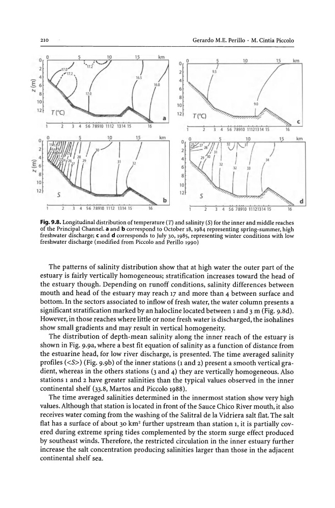
Fig. 9.8. Longitudinal distribution of temperature (n and salinity (S) for the inner and middle reaches
of the Principal Channel. a and b correspond to October 18, 1984 representing spring-summer, high
freshwater discharge; c and d corresponds to July 30, 1985, representing winter conditions with low
freshwater discharge (modified from Piccolo and Perillo 1990)
The patterns of salinity distribution show that at high water the outer part of the
estuary is fairly vertically homogeneous; stratification increases toward the head of
the estuary though. Depending on runoff conditions, salinity differences between
mouth and head of the estuary may reach 17 and more than 4 between surface and
bottom. In the sectors associated to inflow of fresh water, the water column presents a
significant stratification marked by an halo dine located between 1 and 3 m (Fig. 9.8d).
However, in those reaches where little or none fresh water is discharged, the isohalines
show small gradients and may result in vertical homogeneity.
The distribution of depth-mean salinity along the inner reach of the estuary is
shown in Fig. 9.9a, where a best fit equation of salinity as a function of distance from
the estuarine head, for low river discharge, is presented. The time averaged salinity
profiles «5» (Fig. 9.9b) of the inner stations (1 and 2) present a smooth vertical gradient, whereas in the others stations (3 and 4) they are vertically homogeneous. Also
stations 1 and 2 have greater salinities than the typical values observed in the inner
continental shelf (33.8, Martos and Piccolo 1988).
The time averaged salinities determined in the innermost station show very high
values. Although that station is located in front of the Sauce Chico River mouth, it also
receives water coming from the washing of the Salitral de la Vidriera salt flat. The salt
flat has a surface of about 30 km 2 further upstream than station 1, it is partially covered during extreme spring tides complemented by the storm surge effect produced
by southeast winds. Therefore, the restricted circulation in the inner estuary further
increase the salt concentration producing salinities larger than those in the adjacent
continental shelf sea.
c
km
d
Gerardo M.E. Perillo . M. Cintia Piccolo
10
15
km
a
o
15
km
5
b
J 4 S6 78910 1112 1314 IS
8
10
12
J 4 56 78910 1112131415
J 4 56 78910 1112131415
15
Fig. 9.8. Longitudinal distribution of temperature (n and salinity (S) for the inner and middle reaches
of the Principal Channel. a and b correspond to October 18, 1984 representing spring-summer, high
freshwater discharge; c and d corresponds to July 30, 1985, representing winter conditions with low
freshwater discharge (modified from Piccolo and Perillo 1990)
The patterns of salinity distribution show that at high water the outer part of the
estuary is fairly vertically homogeneous; stratification increases toward the head of
the estuary though. Depending on runoff conditions, salinity differences between
mouth and head of the estuary may reach 17 and more than 4 between surface and
bottom. In the sectors associated to inflow of fresh water, the water column presents a
significant stratification marked by an halo dine located between 1 and 3 m (Fig. 9.8d).
However, in those reaches where little or none fresh water is discharged, the isohalines
show small gradients and may result in vertical homogeneity.
The distribution of depth-mean salinity along the inner reach of the estuary is
shown in Fig. 9.9a, where a best fit equation of salinity as a function of distance from
the estuarine head, for low river discharge, is presented. The time averaged salinity
profiles «5» (Fig. 9.9b) of the inner stations (1 and 2) present a smooth vertical gradient, whereas in the others stations (3 and 4) they are vertically homogeneous. Also
stations 1 and 2 have greater salinities than the typical values observed in the inner
continental shelf (33.8, Martos and Piccolo 1988).
The time averaged salinities determined in the innermost station show very high
values. Although that station is located in front of the Sauce Chico River mouth, it also
receives water coming from the washing of the Salitral de la Vidriera salt flat. The salt
flat has a surface of about 30 km 2 further upstream than station 1, it is partially covered during extreme spring tides complemented by the storm surge effect produced
by southeast winds. Therefore, the restricted circulation in the inner estuary further
increase the salt concentration producing salinities larger than those in the adjacent
continental shelf sea.
c
km
d