

140
Jorge Lopez Laborde· Gustavo J. Nagy
These two main transport pathways remain separated in the middle river, due to
the presence of Playa Honda and Gran Hoya del Canal Intermedio, up to Barra del
Indio where they form areas with clay content greater than 25% and mean diameter
under 25 Jlm (corresponding to the salt intrusion limit and the turbidity maximum
location). The outer limit for sediment dispersion would be the zone or band where
recent sediments overlap the relict Holocene sands (Parker et al. 1985; Parker and
Lopez Laborde 1989).
Clay mineralogy studies (Urien 1967; Depetris 1968; Depetris and Griffin 1968;
Siegel et al. 1968), revealed significant differences between the Uruguayan coast and
Samborombon Bay. The differences were originally interpreted as masking of the
physical segregation processes of clay minerals by local contributions of the Uruguayan-Brazilian Coastal Shield. A reinterpretation may be appropriate taking into
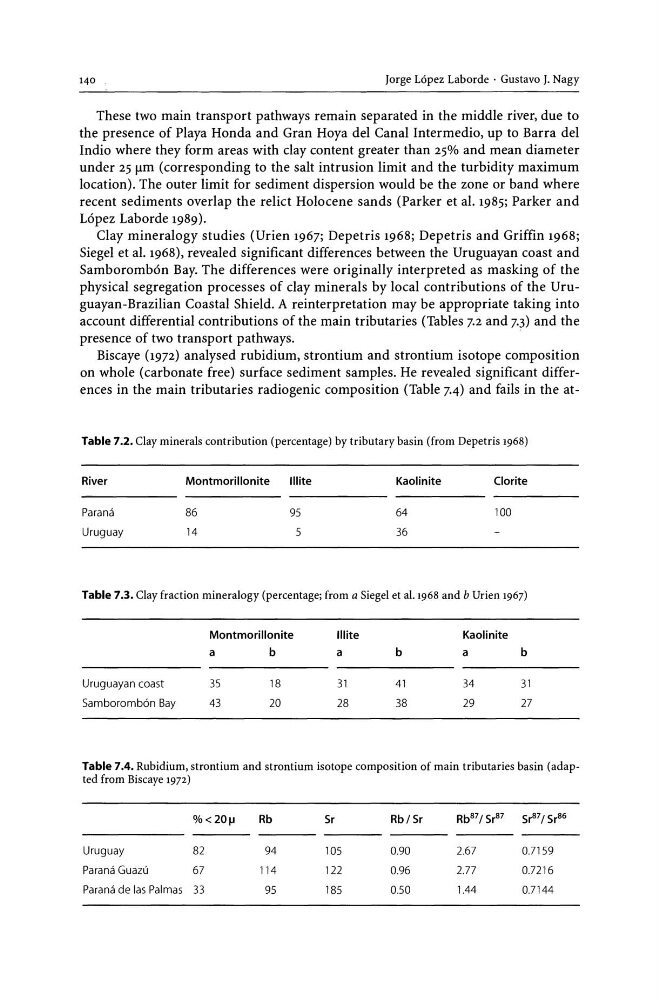
account differential contributions of the main tributaries (Tables 7.2 and 7.3) and the
presence of two transport pathways.
.
Biscaye (1972) analysed rubidium, strontium and strontium isotope composition
on whole (carbonate free) surface sediment samples. He revealed significant differences in the main tributaries radiogenic composition (Table 7.4) and fails in the atTable 7.2. Clay minerals contribution (percentage) by tributary basin (from Depetris 1968)
River
Parana
Uruguay
Montmorillonite
Illite
86
95
14
5
Kaolinite
64
36
Clorite
100
Table 7.3. Clay fraction mineralogy (percentage; from a Siegel et a1.1968 and bUrien 1967)
Uruguayan coast
Samboromb6n Bay
Montmorillonite
a
35
43
b
18
20
Illite
a
31
28
b
41
38
Kaolinite
a
34
29
b
31
27
Table 7.4. Rubidium, strontium and strontium isotope composition of main tributaries basin (adapted from Biscaye 1972)
%<20!l
Rb
5r
RbJ5r
Rb 87 J 5r 87
5r 87 J 5r 86
Uruguay
82
94
105
0.90
2.67
0.7159
Parana Guazu
67
114
122
0.96
2.77
0.7216
Parana de las Palmas 33
95
185
050
1.44
0.7144
Jorge Lopez Laborde· Gustavo J. Nagy
These two main transport pathways remain separated in the middle river, due to
the presence of Playa Honda and Gran Hoya del Canal Intermedio, up to Barra del
Indio where they form areas with clay content greater than 25% and mean diameter
under 25 Jlm (corresponding to the salt intrusion limit and the turbidity maximum
location). The outer limit for sediment dispersion would be the zone or band where
recent sediments overlap the relict Holocene sands (Parker et al. 1985; Parker and
Lopez Laborde 1989).
Clay mineralogy studies (Urien 1967; Depetris 1968; Depetris and Griffin 1968;
Siegel et al. 1968), revealed significant differences between the Uruguayan coast and
Samborombon Bay. The differences were originally interpreted as masking of the
physical segregation processes of clay minerals by local contributions of the Uruguayan-Brazilian Coastal Shield. A reinterpretation may be appropriate taking into
account differential contributions of the main tributaries (Tables 7.2 and 7.3) and the
presence of two transport pathways.
.
Biscaye (1972) analysed rubidium, strontium and strontium isotope composition
on whole (carbonate free) surface sediment samples. He revealed significant differences in the main tributaries radiogenic composition (Table 7.4) and fails in the atTable 7.2. Clay minerals contribution (percentage) by tributary basin (from Depetris 1968)
River
Parana
Uruguay
Montmorillonite
Illite
86
95
14
5
Kaolinite
64
36
Clorite
100
Table 7.3. Clay fraction mineralogy (percentage; from a Siegel et a1.1968 and bUrien 1967)
Uruguayan coast
Samboromb6n Bay
Montmorillonite
a
35
43
b
18
20
Illite
a
31
28
b
41
38
Kaolinite
a
34
29
b
31
27
Table 7.4. Rubidium, strontium and strontium isotope composition of main tributaries basin (adapted from Biscaye 1972)
%<20!l
Rb
5r
RbJ5r
Rb 87 J 5r 87
5r 87 J 5r 86
Uruguay
82
94
105
0.90
2.67
0.7159
Parana Guazu
67
114
122
0.96
2.77
0.7216
Parana de las Palmas 33
95
185
050
1.44
0.7144