

CHAPTER 7· Hydrography and Sediment Transport Characteristics of the Rio de la Plata
135
1. to the north, along the Uruguayan coast, rocky points and sandy beaches predominate (with sand ridges and extensive dune fields, although there are some cliffed
areas developed over a variety of geological formations), and
2. to the south, along the Argentinean coast, a low and flat countryside of marshes,
lagoons, slikkes, shores, and ancient beach ridges predominates.
The Rio de la Plata is the receiving basin of the second largest drainage system of the
continent (3170000 km2; Tossini 1959), formed by the Uruguay and Parami-Paraguay Rivers (Table 7.1), with boundary coordinates between 14°05'-37°37'5 and 67°00'-43°35'W.
250
18
200
16
14
150
12 I
E
.s::.
~
li
10
.,
.s::.
"0
U
.,
~ 100
8 0>
~
6 ~
50
4
2
0
0
4
7
10
13
16
19
22
25
28
31
Transverse se<:tion number
1-- Width
- - Average depth
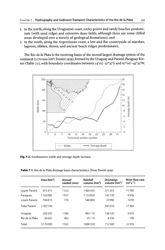
Fig. 7.2. Southeastern width and average depth increase
Table 7.1. Rio de la Plata drainage basin characteristics (from Tossini 1959)
Area (km 2 )
Annual
Rainfall
Discharge
River flow rate
rainfall (mm)
volume (hm 3 ) volume (hm 3 ) (m 3 s- 1 )
Upper Parana
975375
1523
1485420
371 355
11780
Paraguay
1103000
1027
1 l33820
142120
4506
Lower Parana
704815
776
546800
33990
1078
Total Parana
2783190
547610
17364
Uruguay
350250
1385
485110
158720
5033
Rio de la Plata
36650
962
35110
6250
198
Total
3170000
1163
3686330
712580
22505
135
1. to the north, along the Uruguayan coast, rocky points and sandy beaches predominate (with sand ridges and extensive dune fields, although there are some cliffed
areas developed over a variety of geological formations), and
2. to the south, along the Argentinean coast, a low and flat countryside of marshes,
lagoons, slikkes, shores, and ancient beach ridges predominates.
The Rio de la Plata is the receiving basin of the second largest drainage system of the
continent (3170000 km2; Tossini 1959), formed by the Uruguay and Parami-Paraguay Rivers (Table 7.1), with boundary coordinates between 14°05'-37°37'5 and 67°00'-43°35'W.
250
18
200
16
14
150
12 I
E
.s::.
~
li
10
.,
.s::.
"0
U
.,
~ 100
8 0>
~
6 ~
50
4
2
0
0
4
7
10
13
16
19
22
25
28
31
Transverse se<:tion number
1-- Width
- - Average depth
Fig. 7.2. Southeastern width and average depth increase
Table 7.1. Rio de la Plata drainage basin characteristics (from Tossini 1959)
Area (km 2 )
Annual
Rainfall
Discharge
River flow rate
rainfall (mm)
volume (hm 3 ) volume (hm 3 ) (m 3 s- 1 )
Upper Parana
975375
1523
1485420
371 355
11780
Paraguay
1103000
1027
1 l33820
142120
4506
Lower Parana
704815
776
546800
33990
1078
Total Parana
2783190
547610
17364
Uruguay
350250
1385
485110
158720
5033
Rio de la Plata
36650
962
35110
6250
198
Total
3170000
1163
3686330
712580
22505