

134
Jorge L6pez Laborde· Gustavo J. Nagy
7.2
Regional Setting
7.2.1
Drainage Basin
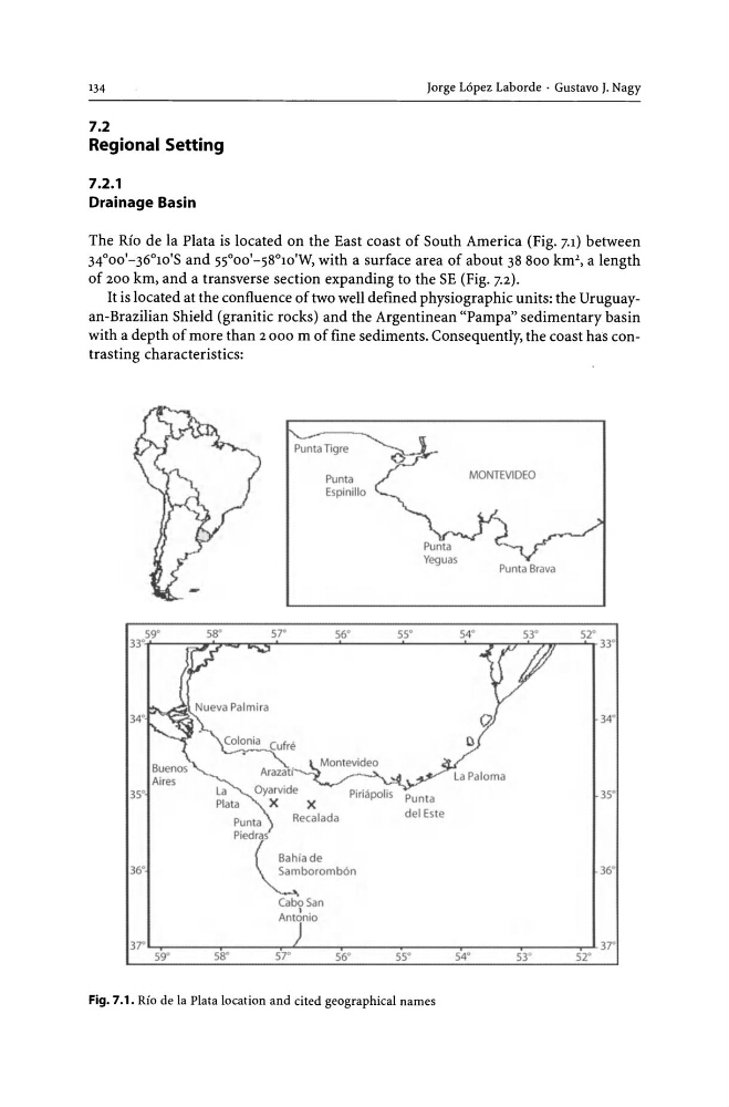
The Rio de la Plata is located on the East coast of South America (Fig. 7.1) between
34°00'-36°1O'S and SSooO'-S8°1O'W, with a surface area of about 38 800 km', a length
of 200 km, and a transverse section expanding to the SE (Fig. 7.2).
It is located at the confluence of two well defined physiographic units: the Uruguayan-Brazilian Shield (granitic rocks) and the Argentinean "Pampa" sedimentary basin
with a depth of more than 2000 m of fine sediments. Consequently, the coast has contrasting characteristics:
Punta Tigre
Punt"
Espinillo
MONTEVIDEO
Punta Brava
S9"
58'
57'
56'
55'
54'
53'
52'
33··~--~~~~~~~------~------~------~-y~~~~---4T 33·
35'
36'
Punta
Piedras
x
Recalada
(
~ahiade
~boromb6n
Cabo San
Ant~nio
Punta
del Este
Fig. 7.1. Rio de la Plata location and cited geographical names
34'
35'
36'
Jorge L6pez Laborde· Gustavo J. Nagy
7.2
Regional Setting
7.2.1
Drainage Basin
The Rio de la Plata is located on the East coast of South America (Fig. 7.1) between
34°00'-36°1O'S and SSooO'-S8°1O'W, with a surface area of about 38 800 km', a length
of 200 km, and a transverse section expanding to the SE (Fig. 7.2).
It is located at the confluence of two well defined physiographic units: the Uruguayan-Brazilian Shield (granitic rocks) and the Argentinean "Pampa" sedimentary basin
with a depth of more than 2000 m of fine sediments. Consequently, the coast has contrasting characteristics:
Punta Tigre
Punt"
Espinillo
MONTEVIDEO
Punta Brava
S9"
58'
57'
56'
55'
54'
53'
52'
33··~--~~~~~~~------~------~------~-y~~~~---4T 33·
35'
36'
Punta
Piedras
x
Recalada
(
~ahiade
~boromb6n
Cabo San
Ant~nio
Punta
del Este
Fig. 7.1. Rio de la Plata location and cited geographical names
34'
35'
36'