

CHAPTER 6 . The Argentina Estuaries: A Review
125
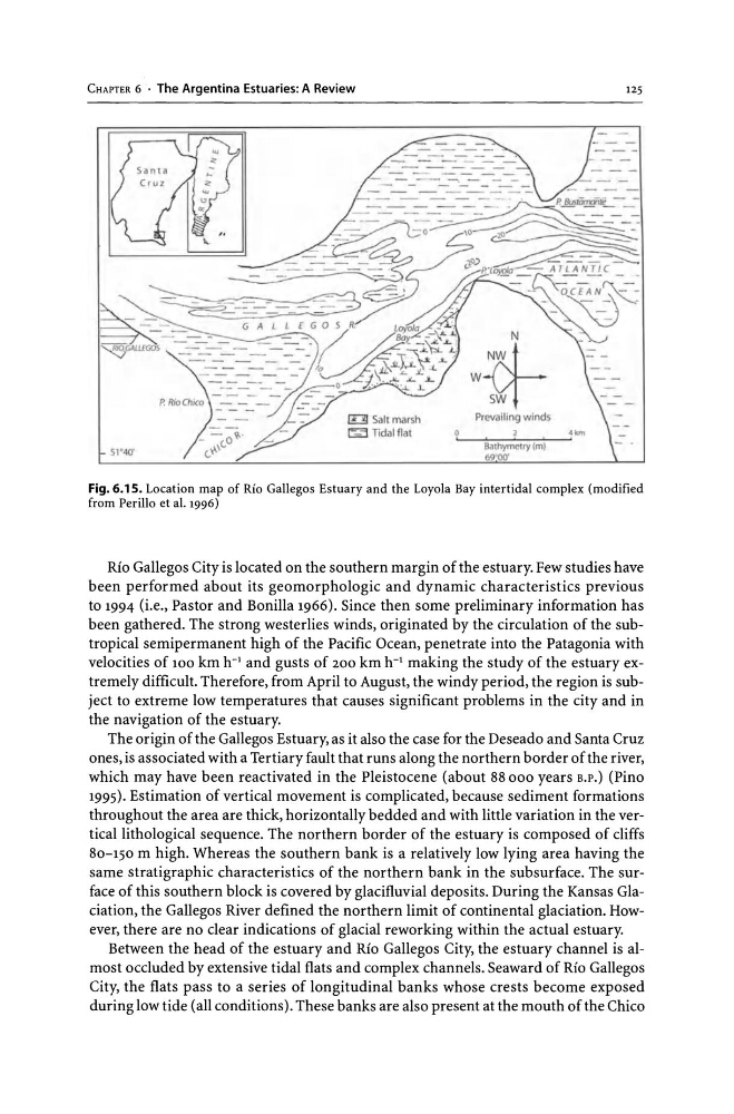
Fig. 6.15. Location map of Rio Gallegos Estuary and the Loyola Bay intertidal complex (modified
from Perillo et al. 1996)
Rio Gallegos City is located on the southern margin of the estuary. Few studies have
been performed about its geomorphologic and dynamic characteristics previous
to 1994 (i.e., Pastor and Bonilla 1966). Since then some preliminary information has
been gathered. The strong westerlies winds, originated by the circulation of the subtropical semipermanent high of the Pacific Ocean, penetrate into the Patagonia with
velocities of 100 km h- 1 and gusts of 200 km h- 1 making the study of the estuary extremely difficult. Therefore, from April to August, the windy period, the region is subject to extreme low temperatures that causes significant problems in the city and in
the navigation of the estuary.
The origin of the Gallegos Estuary, as it also the case for the Deseado and Santa Cruz
ones, is associated with a Tertiary fault that runs along the northern border of the river,
which may have been reactivated in the Pleistocene (about 88000 years B.P.) (Pino
1995). Estimation of vertical movement is complicated, because sediment formations
throughout the area are thick, horizontally bedded and with little variation in the vertical lithological sequence. The northern border of the estuary is composed of cliffs
80-150 m high. Whereas the southern bank is a relatively low lying area having the
same stratigraphic characteristics of the northern bank in the subsurface. The surface of this southern block is covered by glacifluvial deposits. During the Kansas Glaciation, the Gallegos River defined the northern limit of continental glaciation. However, there are no clear indications of glacial reworking within the actual estuary.
Between the head of the estuary and Rio Gallegos City, the estuary channel is almost occluded by extensive tidal flats and complex channels. Seaward of Rio Gallegos
City, the flats pass to a series of longitudinal banks whose crests become exposed
during low tide (all conditions). These banks are also present at the mouth of the Chico
125
Fig. 6.15. Location map of Rio Gallegos Estuary and the Loyola Bay intertidal complex (modified
from Perillo et al. 1996)
Rio Gallegos City is located on the southern margin of the estuary. Few studies have
been performed about its geomorphologic and dynamic characteristics previous
to 1994 (i.e., Pastor and Bonilla 1966). Since then some preliminary information has
been gathered. The strong westerlies winds, originated by the circulation of the subtropical semipermanent high of the Pacific Ocean, penetrate into the Patagonia with
velocities of 100 km h- 1 and gusts of 200 km h- 1 making the study of the estuary extremely difficult. Therefore, from April to August, the windy period, the region is subject to extreme low temperatures that causes significant problems in the city and in
the navigation of the estuary.
The origin of the Gallegos Estuary, as it also the case for the Deseado and Santa Cruz
ones, is associated with a Tertiary fault that runs along the northern border of the river,
which may have been reactivated in the Pleistocene (about 88000 years B.P.) (Pino
1995). Estimation of vertical movement is complicated, because sediment formations
throughout the area are thick, horizontally bedded and with little variation in the vertical lithological sequence. The northern border of the estuary is composed of cliffs
80-150 m high. Whereas the southern bank is a relatively low lying area having the
same stratigraphic characteristics of the northern bank in the subsurface. The surface of this southern block is covered by glacifluvial deposits. During the Kansas Glaciation, the Gallegos River defined the northern limit of continental glaciation. However, there are no clear indications of glacial reworking within the actual estuary.
Between the head of the estuary and Rio Gallegos City, the estuary channel is almost occluded by extensive tidal flats and complex channels. Seaward of Rio Gallegos
City, the flats pass to a series of longitudinal banks whose crests become exposed
during low tide (all conditions). These banks are also present at the mouth of the Chico