

124
M. Cintia Piccolo . Gerardo M.E. Perillo
~""
o
Skm
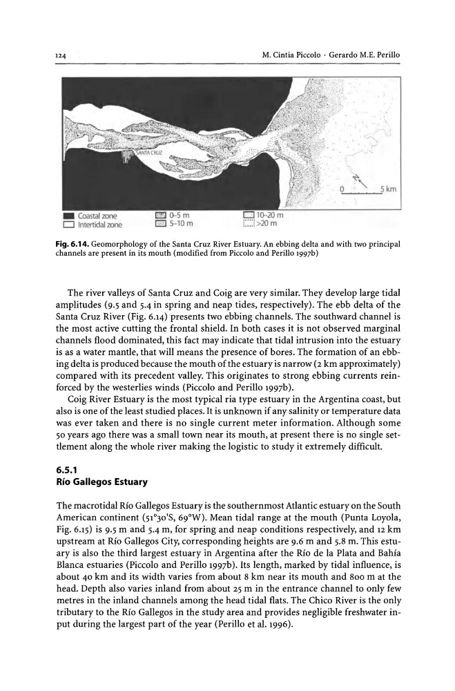
Fig. 6.14. Geomorphology of the Santa Cruz River Estuary. An ebbing delta and with two principal
channels are present in its mouth (modified from Piccolo and Perillo 1997b)
The river valleys of Santa Cruz and Coig are very similar. They develop large tidal
amplitudes (9.5 and 5.4 in spring and neap tides, respectively). The ebb delta of the
Santa Cruz River (Fig. 6.14) presents two ebbing channels. The southward channel is
the most active cutting the frontal shield. In both cases it is not observed marginal
channels flood dominated, this fact may indicate that tidal intrusion into the estuary
is as a water mantle, that will means the presence of bores. The formation of an ebbing delta is produced because the mouth of the estuary is narrow (2 km approximately)
compared with its precedent valley. This originates to strong ebbing currents reinforced by the westerlies winds (Piccolo and Perillo 1997b).
Coig River Estuary is the most typical ria type estuary in the Argentina coast, but
also is one of the least studied places. It is unknown if any salinity or temperature data
was ever taken and there is no single current meter information. Although some
50 years ago there was a small town near its mouth, at present there is no single settlement along the whole river making the logistic to study it extremely difficult.
6.5.1
Rio Gallegos Estuary
The macrotidal Rio Gallegos Estuary is the southernmost Atlantic estuary on the South
American continent (51°30'S, 69°W). Mean tidal range at the mouth (Punta Loyola,
Fig. 6.15) is 9.5 m and 5.4 m, for spring and neap conditions respectively, and 12 km
upstream at Rio Gallegos City, corresponding heights are 9.6 m and 5.8 m. This estuary is also the third largest estuary in Argentina after the Rio de la Plata and Bahia
Blanca estuaries (Piccolo and Perillo 1997b). Its length, marked by tidal influence, is
about 40 km and its width varies from about 8 km near its mouth and 800 m at the
head. Depth also varies inland from about 25 m in the entrance channel to only few
metres in the inland channels among the head tidal flats. The Chico River is the only
tributary to the Rio Gallegos in the study area and provides negligible freshwater input during the largest part of the year (Perillo et al. 1996).
M. Cintia Piccolo . Gerardo M.E. Perillo
~""
o
Skm
Fig. 6.14. Geomorphology of the Santa Cruz River Estuary. An ebbing delta and with two principal
channels are present in its mouth (modified from Piccolo and Perillo 1997b)
The river valleys of Santa Cruz and Coig are very similar. They develop large tidal
amplitudes (9.5 and 5.4 in spring and neap tides, respectively). The ebb delta of the
Santa Cruz River (Fig. 6.14) presents two ebbing channels. The southward channel is
the most active cutting the frontal shield. In both cases it is not observed marginal
channels flood dominated, this fact may indicate that tidal intrusion into the estuary
is as a water mantle, that will means the presence of bores. The formation of an ebbing delta is produced because the mouth of the estuary is narrow (2 km approximately)
compared with its precedent valley. This originates to strong ebbing currents reinforced by the westerlies winds (Piccolo and Perillo 1997b).
Coig River Estuary is the most typical ria type estuary in the Argentina coast, but
also is one of the least studied places. It is unknown if any salinity or temperature data
was ever taken and there is no single current meter information. Although some
50 years ago there was a small town near its mouth, at present there is no single settlement along the whole river making the logistic to study it extremely difficult.
6.5.1
Rio Gallegos Estuary
The macrotidal Rio Gallegos Estuary is the southernmost Atlantic estuary on the South
American continent (51°30'S, 69°W). Mean tidal range at the mouth (Punta Loyola,
Fig. 6.15) is 9.5 m and 5.4 m, for spring and neap conditions respectively, and 12 km
upstream at Rio Gallegos City, corresponding heights are 9.6 m and 5.8 m. This estuary is also the third largest estuary in Argentina after the Rio de la Plata and Bahia
Blanca estuaries (Piccolo and Perillo 1997b). Its length, marked by tidal influence, is
about 40 km and its width varies from about 8 km near its mouth and 800 m at the
head. Depth also varies inland from about 25 m in the entrance channel to only few
metres in the inland channels among the head tidal flats. The Chico River is the only
tributary to the Rio Gallegos in the study area and provides negligible freshwater input during the largest part of the year (Perillo et al. 1996).