

104
M. Cintia Piccolo· Gerardo M.E. Perillo
6.2
Rio de la Plata Estuary
The Argentina coast starts in the Rio de la Plata Estuary (Fig. 6.1), located at about
35°S on the Atlantic coast of South America. After the Amazon River, the Rio de la Plata
including its two major tributaries (Parana and Uruguay Rivers) is one of the major
waterways of the Southern Hemisphere as well as the second largest basin in Latin
America (over 3 000 000 km2). Two major harbours and many cities are located on
its shore from which Buenos Aires (Argentina) and Montevideo (Uruguay) are the
largest and better known.
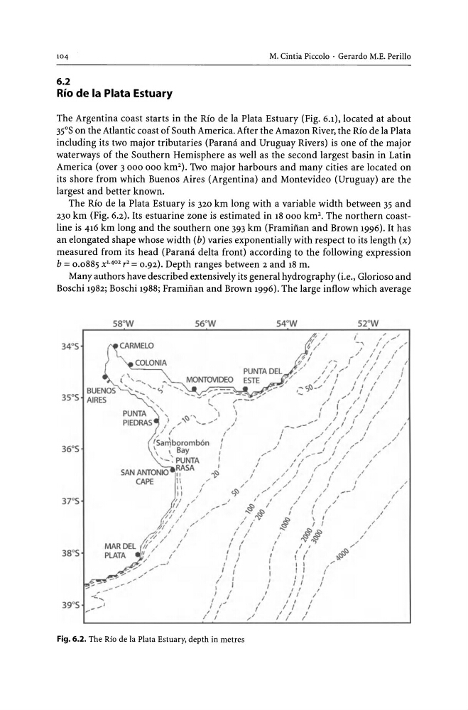
The Rio de la Plata Estuary is 320 km long with a variable width between 35 and
230 km (Fig. 6.2). Its estuarine zone is estimated in 18000 km 2 . The northern coastline is 416 km long and the southern one 393 km (Framiiian and Brown 1996). It has
an elongated shape whose width (b) varies exponentially with respect to its length (x)
measured from its head (Parana delta front) according to the following expression
b = 0.0885 X1. 402 r 2 = 0.92). Depth ranges between 2 and 18 m.
Many authors have described extensively its general hydrography (i.e., Glorioso and
Boschi 1982; Boschi 1988; Framiiian and Brown 1996). The large inflow which average
34°S
37'S
39°S
58°W
56°W
---. ...
,,- -'
, ....
PUNTA
'\
')
1:) "'
PIEDRAS
'" "
.... _./
{ /
/ I
fSan\boromb6n
\
; Bay
'-: PUNTA
SAN ANTONIO RASA
CAPE
r
'"
,
I
,
~
I
/
I
/
."
.• /
1 / '
/_
,/1
I
/
'II
I
""
II
I
...
W " / '
';f'
I
I
// /
I
i'~
/
I
/ I '
I
11 ,/
/'
"' -'
I
/
Fig. 6.2. The Rio de la Plata Estuary, depth in metres
{
I
"
{
I
I
,
I
I
I
I
54°W
{
I
/
/
I
I
I
I
I
\
,
I I
~~
"V"j
I ,
,
I
I I
, I
I I
, ,
I I
I I
/ I
I I
I I
I
,
I I
I
(
I
,
,
/
I
I
{
/
,
I
52°W
I
/
/
,
/
,
"
/
{
/
I
/
,
/
I
"'
,
,
I
,
,
/
/
/
M. Cintia Piccolo· Gerardo M.E. Perillo
6.2
Rio de la Plata Estuary
The Argentina coast starts in the Rio de la Plata Estuary (Fig. 6.1), located at about
35°S on the Atlantic coast of South America. After the Amazon River, the Rio de la Plata
including its two major tributaries (Parana and Uruguay Rivers) is one of the major
waterways of the Southern Hemisphere as well as the second largest basin in Latin
America (over 3 000 000 km2). Two major harbours and many cities are located on
its shore from which Buenos Aires (Argentina) and Montevideo (Uruguay) are the
largest and better known.
The Rio de la Plata Estuary is 320 km long with a variable width between 35 and
230 km (Fig. 6.2). Its estuarine zone is estimated in 18000 km 2 . The northern coastline is 416 km long and the southern one 393 km (Framiiian and Brown 1996). It has
an elongated shape whose width (b) varies exponentially with respect to its length (x)
measured from its head (Parana delta front) according to the following expression
b = 0.0885 X1. 402 r 2 = 0.92). Depth ranges between 2 and 18 m.
Many authors have described extensively its general hydrography (i.e., Glorioso and
Boschi 1982; Boschi 1988; Framiiian and Brown 1996). The large inflow which average
34°S
37'S
39°S
58°W
56°W
---. ...
,,- -'
, ....
PUNTA
'\
')
1:) "'
PIEDRAS
'" "
.... _./
{ /
/ I
fSan\boromb6n
\
; Bay
'-: PUNTA
SAN ANTONIO RASA
CAPE
r
'"
,
I
,
~
I
/
I
/
."
.• /
1 / '
/_
,/1
I
/
'II
I
""
II
I
...
W " / '
';f'
I
I
// /
I
i'~
/
I
/ I '
I
11 ,/
/'
"' -'
I
/
Fig. 6.2. The Rio de la Plata Estuary, depth in metres
{
I
"
{
I
I
,
I
I
I
I
54°W
{
I
/
/
I
I
I
I
I
\
,
I I
~~
"V"j
I ,
,
I
I I
, I
I I
, ,
I I
I I
/ I
I I
I I
I
,
I I
I
(
I
,
,
/
I
I
{
/
,
I
52°W
I
/
/
,
/
,
"
/
{
/
I
/
,
/
I
"'
,
,
I
,
,
/
/
/