

7.3 Wind-Driven Surface and Near-Surface Currents
211
~~~ -- ~--- - ---------~ ..
South Pacific
~V Gy", ~
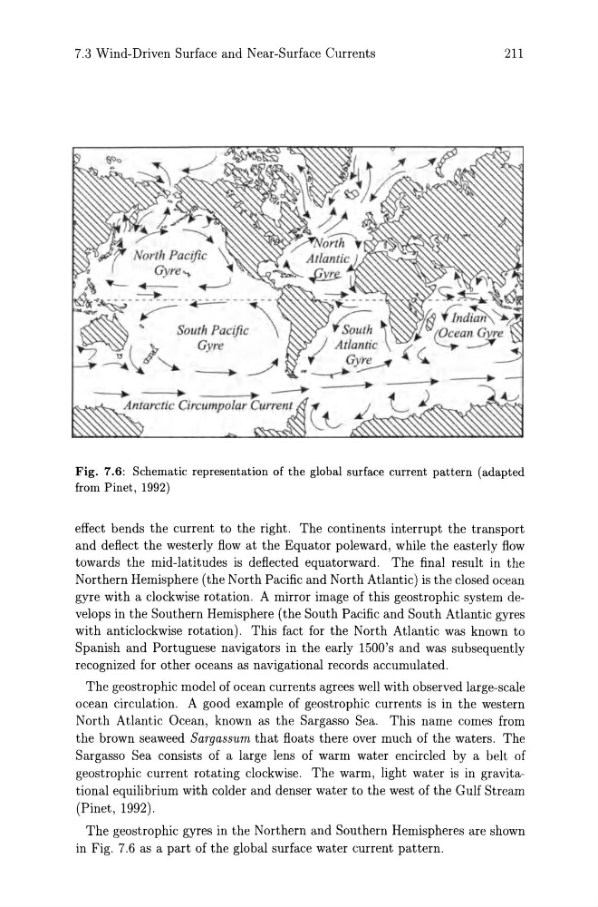
Fig. 7.6: Schematic representation of the global surface current pattern (adapted
from Pinet, 1992)
effect bends the current to the right. The continents interrupt the transport
and deflect the westerly flow at the Equator poleward, while the easterly flow
towards the mid-latitudes is deflected equatorward. The final result in the
Northern Hemisphere (the North Pacific and North Atlantic) is the closed ocean
gyre with a clockwise rotation. A mirror image of this geostrophic system develops in the Southern Hemisphere (the South Pacific and South Atlantic gyres
with anticlockwise rotation). This fact for the North Atlantic was known to
Spanish and Portuguese navigators in the early 1500's and was subsequently
recognized for other oceans as navigational records accumulated.
The geostrophic model of ocean currents agrees well with observed large-scale
ocean circulation. A good example of geostrophic currents is in the western
North Atlantic Ocean, known as the Sargasso Sea. This name comes from
the brown seaweed Sargassum that floats there over much of the waters. The
Sargasso Sea consists of a large lens of warm water encircled by a belt of
geostrophic current rotating clockwise. The warm, light water is in gravitational equilibrium with colder and denser water to the west of the Gulf Stream
(Pinet, 1992).
The geostrophic gyres in the Northern and Southern Hemispheres are shown
in Fig. 7.6 as a part of the global surface water current pattern.
211
~~~ -- ~--- - ---------~ ..
South Pacific
~V Gy", ~
Fig. 7.6: Schematic representation of the global surface current pattern (adapted
from Pinet, 1992)
effect bends the current to the right. The continents interrupt the transport
and deflect the westerly flow at the Equator poleward, while the easterly flow
towards the mid-latitudes is deflected equatorward. The final result in the
Northern Hemisphere (the North Pacific and North Atlantic) is the closed ocean
gyre with a clockwise rotation. A mirror image of this geostrophic system develops in the Southern Hemisphere (the South Pacific and South Atlantic gyres
with anticlockwise rotation). This fact for the North Atlantic was known to
Spanish and Portuguese navigators in the early 1500's and was subsequently
recognized for other oceans as navigational records accumulated.
The geostrophic model of ocean currents agrees well with observed large-scale
ocean circulation. A good example of geostrophic currents is in the western
North Atlantic Ocean, known as the Sargasso Sea. This name comes from
the brown seaweed Sargassum that floats there over much of the waters. The
Sargasso Sea consists of a large lens of warm water encircled by a belt of
geostrophic current rotating clockwise. The warm, light water is in gravitational equilibrium with colder and denser water to the west of the Gulf Stream
(Pinet, 1992).
The geostrophic gyres in the Northern and Southern Hemispheres are shown
in Fig. 7.6 as a part of the global surface water current pattern.