

Annex B: ISO 19115 Metadata package data dictionaries
27 1
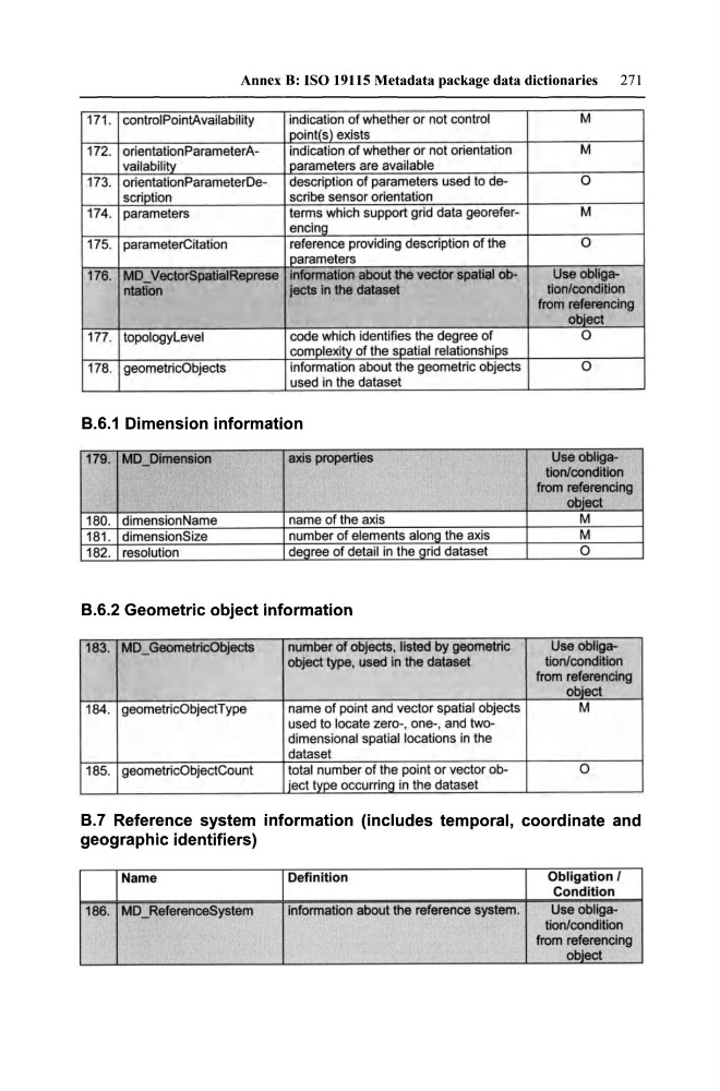
171 . controlPointAvailability
indication of whether or not control
M
i point(s) exists
172. orientationParameterAindication of whether or not orientation
M
vailabilL~
I parameters are available
173. orientationParameterDedescription of parameters used to deO
scription
scribe sensor orientation
174. parameters
terms wh ich support grid data georeferM
encing
175. parameterCitation
reference providing description of the
0
I parameters
176. MD _ VectorSpatialReprese information about the vector spatial obUsa obligantatlon
jects In the dataset
tion/condition
from referencing
obiect
177. topologylevel
code which identifies the degree of
0
complexity of the spatial relationships
178. geometricObjects
information about the geometric objects
0
used in the dataset
8.6.1 Dimension information
179. MD_Dimension
axis properties
Usa obIigation/condition
frorn referencing
obiect
180. dimension Name
name of the axis
M
181 . dimensionSize
number of elements along the axis
M
182. resolution
degree of detail in the grid dataset
0
8.6.2 Geometrie objeet information
183. MD _ GeometricObjects
number of objects, listed by geometric
Usa obIigaobject type, used in the datasat
tion/condition
frorn referencing
object
184. geometricObjectType
name of point and vector spatial objects
M
used to loeate zero-, one-, and twodimensional spatial loeations in the
dataset
185. geometricObjectCount
total number of the point or vector ob0
iect type occurring in the dataset
8.7 Referenee system information (ineludes temporal, eoordinate and
geographie identifiers)
Name
Definitio n
Ob ligatio n I
Condition
186. MD _ReferenceSystem
information about the reference system.
Usa obligation/condition
from referencing
object
27 1
171 . controlPointAvailability
indication of whether or not control
M
i point(s) exists
172. orientationParameterAindication of whether or not orientation
M
vailabilL~
I parameters are available
173. orientationParameterDedescription of parameters used to deO
scription
scribe sensor orientation
174. parameters
terms wh ich support grid data georeferM
encing
175. parameterCitation
reference providing description of the
0
I parameters
176. MD _ VectorSpatialReprese information about the vector spatial obUsa obligantatlon
jects In the dataset
tion/condition
from referencing
obiect
177. topologylevel
code which identifies the degree of
0
complexity of the spatial relationships
178. geometricObjects
information about the geometric objects
0
used in the dataset
8.6.1 Dimension information
179. MD_Dimension
axis properties
Usa obIigation/condition
frorn referencing
obiect
180. dimension Name
name of the axis
M
181 . dimensionSize
number of elements along the axis
M
182. resolution
degree of detail in the grid dataset
0
8.6.2 Geometrie objeet information
183. MD _ GeometricObjects
number of objects, listed by geometric
Usa obIigaobject type, used in the datasat
tion/condition
frorn referencing
object
184. geometricObjectType
name of point and vector spatial objects
M
used to loeate zero-, one-, and twodimensional spatial loeations in the
dataset
185. geometricObjectCount
total number of the point or vector ob0
iect type occurring in the dataset
8.7 Referenee system information (ineludes temporal, eoordinate and
geographie identifiers)
Name
Definitio n
Ob ligatio n I
Condition
186. MD _ReferenceSystem
information about the reference system.
Usa obligation/condition
from referencing
object