

270
Annexes
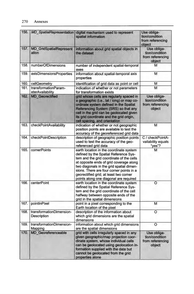
156. MD _ SpatialRepresentation digital mechanlsm used to represent
Use obligaspatIaJ Information
tionlcondition
from referencing
obiect
157. MD _ GridSpatialRepresent Information about grid spatial obJects in
Use obligaation
the data8et
tionlcondition
from referencing
obiect
158. numberOfDimensions
number of independent spatial-temporal
M
axes
159. axisDimensionsProperties information about spalial-temporal axis
M
properties
160. celiGeometrV
identification of arid data as point or eell
M
161 . transformationParamindication of whether or not parameters
M
eterAvailabilitv
for transformation exists
162. MD _ Georectified
grId whoee ceUs are regularfy spaced in
Use obIigaa geographlc (I.e., Iat 11ong) or map cotionlcondition
ordinate system deftned In the Spatlal
from referencing
Ref8rencIng System (SRS) so that any
object
ceII in the grtd can be geoIocated given
iIa grId COOfdInate and the grid origln,
ceA~ sDaclna. and orIentation
163. eheekPointAvailability
indieation of whether or not geographie
M
position points are available to test the
aeeuraev of the aeorefereneed grid data
164. eheekPointDeseription
descriplion of geographie posilion points C I checkPointAused 10 test Ihe aeeuraey of the geovailability equals
referenced arid data
"ves"?
165. cornerPoints
earth location in the coordinate system
M
defined by the Spalial Referenee System and Ihe grid coordinate of Ihe cells
al opposite ends of grid eoverage along
two diagonals in the grid spatial dimensions. There are four corner points in a
georeetified grid; al least Iwo corner
I Doinls alona one diagonal are reQuired
166. cenlerPoinl
earth loealion in the eoordinate system
0
defined by Ihe Spatial Reference Syslem and Ihe grid coordinate of the eell
halfway belween opposile ends of the
I arid in the sDatial dimensions
167. pointInPixel
poinl in a pixel eorresponding to Ihe
M
Earth loealion of Ihe pixel
168. IransformalionDimension- descriplion of the informalion about
0
Deseription
wh ich grid dimensions are the spatial
dimensions
169. transformation Dimension- information about whieh grid dimensions
0
MaDDina
are the sDatial dimensions
170. MD _ Georeferenceable
grid with cells Irregular1y spaced in any
Useobligagiven geographlclrnap projection coortionlcondition
dlnate system, whose individual cells
from referencing
ean be geoiocated using geoiocation Inobject
formation supplled with the data but
cannot be geoIocated from the grid
DrooertieS alone
Annexes
156. MD _ SpatialRepresentation digital mechanlsm used to represent
Use obligaspatIaJ Information
tionlcondition
from referencing
obiect
157. MD _ GridSpatialRepresent Information about grid spatial obJects in
Use obligaation
the data8et
tionlcondition
from referencing
obiect
158. numberOfDimensions
number of independent spatial-temporal
M
axes
159. axisDimensionsProperties information about spalial-temporal axis
M
properties
160. celiGeometrV
identification of arid data as point or eell
M
161 . transformationParamindication of whether or not parameters
M
eterAvailabilitv
for transformation exists
162. MD _ Georectified
grId whoee ceUs are regularfy spaced in
Use obIigaa geographlc (I.e., Iat 11ong) or map cotionlcondition
ordinate system deftned In the Spatlal
from referencing
Ref8rencIng System (SRS) so that any
object
ceII in the grtd can be geoIocated given
iIa grId COOfdInate and the grid origln,
ceA~ sDaclna. and orIentation
163. eheekPointAvailability
indieation of whether or not geographie
M
position points are available to test the
aeeuraev of the aeorefereneed grid data
164. eheekPointDeseription
descriplion of geographie posilion points C I checkPointAused 10 test Ihe aeeuraey of the geovailability equals
referenced arid data
"ves"?
165. cornerPoints
earth location in the coordinate system
M
defined by the Spalial Referenee System and Ihe grid coordinate of Ihe cells
al opposite ends of grid eoverage along
two diagonals in the grid spatial dimensions. There are four corner points in a
georeetified grid; al least Iwo corner
I Doinls alona one diagonal are reQuired
166. cenlerPoinl
earth loealion in the eoordinate system
0
defined by Ihe Spatial Reference Syslem and Ihe grid coordinate of the eell
halfway belween opposile ends of the
I arid in the sDatial dimensions
167. pointInPixel
poinl in a pixel eorresponding to Ihe
M
Earth loealion of Ihe pixel
168. IransformalionDimension- descriplion of the informalion about
0
Deseription
wh ich grid dimensions are the spatial
dimensions
169. transformation Dimension- information about whieh grid dimensions
0
MaDDina
are the sDatial dimensions
170. MD _ Georeferenceable
grid with cells Irregular1y spaced in any
Useobligagiven geographlclrnap projection coortionlcondition
dlnate system, whose individual cells
from referencing
ean be geoiocated using geoiocation Inobject
formation supplled with the data but
cannot be geoIocated from the grid
DrooertieS alone