

4.4 Simple Features (ISO 19125-1)
163
MultiPolygon
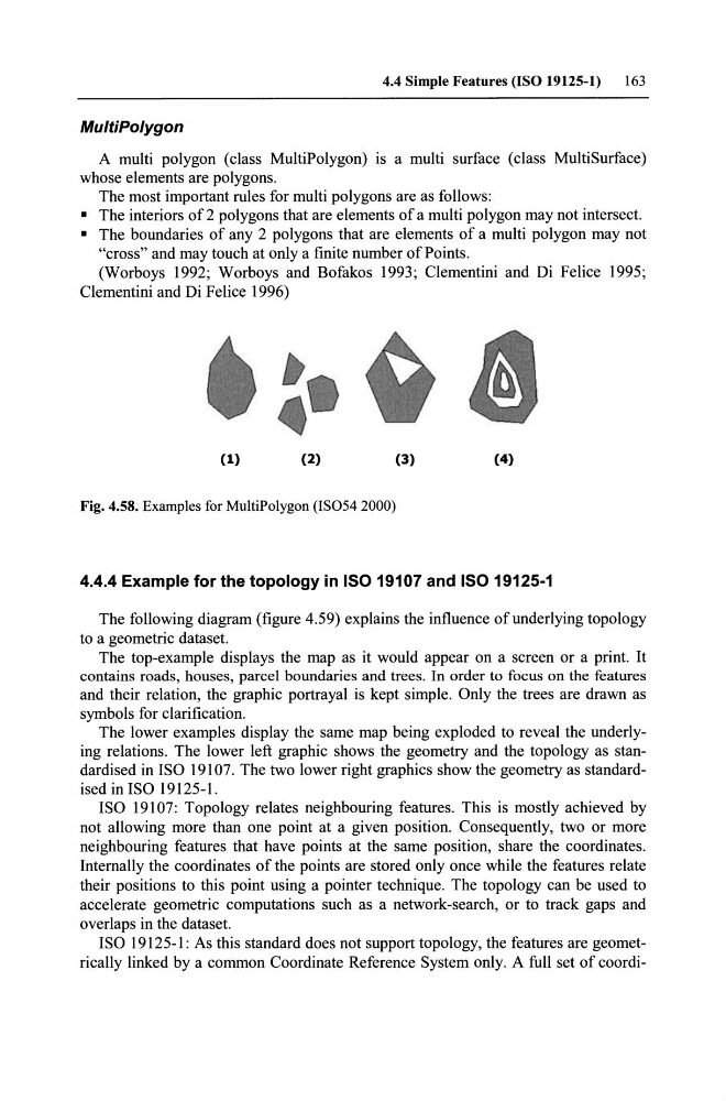
A multi polygon (dass MultiPolygon) is a multi surface (dass MultiSurface)
whose elements are polygons.
The most important rules for multi polygons are as folIows:
• The interiors of 2 polygons that are elements of a multi polygon may not intersect.
• The boundaries of any 2 polygons that are elements of a multi polygon may not
"cross" and may touch at only a finite number ofPoints.
(Worboys 1992; Worboys and Bofakos 1993; Clementini and Di Felice 1995;
Clementini and Di Felice 1996)
(1)
(2)
(3)
(4)
Fig. 4.58. Examples for MultiPolygon (IS054 2000)
4.4.4 Example for the topology in ISO 19107 and ISO 19125-1
The following diagram (figure 4.59) explains the influence ofunderlying topology
to a geometrie dataset.
The top-example displays the map as it would appear on a screen or a print. It
contains roads, houses, parcel boundaries and trees. In order to focus on the features
and their relation, the graphie portrayal is kept simple. Only the trees are drawn as
symbols for darification.
The lower examples display the same map being exploded to reveal the underlying relations. The lower left graphie shows the geometry and the topology as standardised in ISO 19107. The two lower right graphics show the geometry as standardised in ISO 19125-1.
ISO 19107: Topology relates neighbouring features. This is mostly achieved by
not allowing more than one point at a given position. Consequently, two or more
neighbouring features that have points at the same position, share the coordinates.
Intemally the coordinates of the points are stored only once while the features relate
their positions to this point using apointer technique. The topology can be used to
accelerate geometrie computations such as a network-search, or to track gaps and
overlaps in the dataset.
ISO 19125-1: As this standard does not support topology, the features are geometrically linked by a common Coordinate Reference System only. A full set of coordi-
163
MultiPolygon
A multi polygon (dass MultiPolygon) is a multi surface (dass MultiSurface)
whose elements are polygons.
The most important rules for multi polygons are as folIows:
• The interiors of 2 polygons that are elements of a multi polygon may not intersect.
• The boundaries of any 2 polygons that are elements of a multi polygon may not
"cross" and may touch at only a finite number ofPoints.
(Worboys 1992; Worboys and Bofakos 1993; Clementini and Di Felice 1995;
Clementini and Di Felice 1996)
(1)
(2)
(3)
(4)
Fig. 4.58. Examples for MultiPolygon (IS054 2000)
4.4.4 Example for the topology in ISO 19107 and ISO 19125-1
The following diagram (figure 4.59) explains the influence ofunderlying topology
to a geometrie dataset.
The top-example displays the map as it would appear on a screen or a print. It
contains roads, houses, parcel boundaries and trees. In order to focus on the features
and their relation, the graphie portrayal is kept simple. Only the trees are drawn as
symbols for darification.
The lower examples display the same map being exploded to reveal the underlying relations. The lower left graphie shows the geometry and the topology as standardised in ISO 19107. The two lower right graphics show the geometry as standardised in ISO 19125-1.
ISO 19107: Topology relates neighbouring features. This is mostly achieved by
not allowing more than one point at a given position. Consequently, two or more
neighbouring features that have points at the same position, share the coordinates.
Intemally the coordinates of the points are stored only once while the features relate
their positions to this point using apointer technique. The topology can be used to
accelerate geometrie computations such as a network-search, or to track gaps and
overlaps in the dataset.
ISO 19125-1: As this standard does not support topology, the features are geometrically linked by a common Coordinate Reference System only. A full set of coordi-