

468
G.E. Glass et al.
increase has also been documented in atmospheric mercury concentrations
(Slemr and Langer 1992). This is consistent with elevated mercury levels observed
in soil (Nater and Grigal 1992) and sediment (Swain et al. 1992), which may be
explained by recent atmospheric mercury deposition (Sorensen et al. 1994, 1990).
Mercury deposition from precipitation measured in the past 3 years was
significantly higher than for the previous period 1990-1992 (Glass et al. 1996).
However, some studies of mercury in wetlands show maximum values in mercury
corresponding to accumulations during the period 1935-1980 (Benoit et al. 1994).
Our assessment studies have contributed to quantifying the extent of mercury
contamination throughout the St. Louis River, the largest US tributary to Lake
Superior, and its watershed, and have identified some contaminated hot-spots
(Glass et al. 1990, 1992).
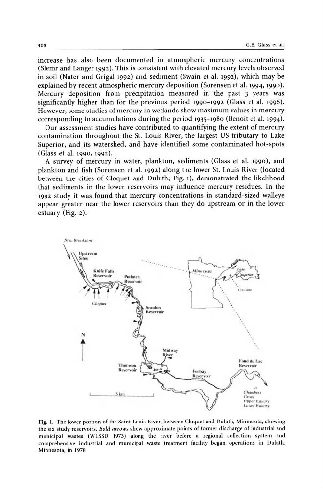
A survey of mercury in water, plankton, sediments (Glass et al. 1990), and
plankton and fish (Sorensen et al. 1992) along the lower St. Louis River (located
between the cities of Cloquet and Duluth; Fig. 1), demonstrated the likelihood
that sediments in the lower reservoirs may influence mercury residues. In the
1992 study it was found that mercury concentrations in standard-sized walleye
appear greater near the lower reservoirs than they do upstream or in the lower
estuary (Fig. 2).
\
N
i
'l 'IUun:SOfl
R CStI"V4-)jf"
Skill
'0
( '/",,,,hus
( irovr
Upper f.°lllWr)'
U'M'f: r Escuar)'
Fig. 1. The lower portion of the Saint Louis River, between Cloquet and Duluth, Minnesota, showing
the six study reservoirs. Bold arrows show approximate points of former discharge of industrial and
municipal wastes (WLSSD 1973) along the river before a regional collection system and
comprehensive industrial and municipal waste treatment facility began operations in Duluth,
Minnesota, in 1978
G.E. Glass et al.
increase has also been documented in atmospheric mercury concentrations
(Slemr and Langer 1992). This is consistent with elevated mercury levels observed
in soil (Nater and Grigal 1992) and sediment (Swain et al. 1992), which may be
explained by recent atmospheric mercury deposition (Sorensen et al. 1994, 1990).
Mercury deposition from precipitation measured in the past 3 years was
significantly higher than for the previous period 1990-1992 (Glass et al. 1996).
However, some studies of mercury in wetlands show maximum values in mercury
corresponding to accumulations during the period 1935-1980 (Benoit et al. 1994).
Our assessment studies have contributed to quantifying the extent of mercury
contamination throughout the St. Louis River, the largest US tributary to Lake
Superior, and its watershed, and have identified some contaminated hot-spots
(Glass et al. 1990, 1992).
A survey of mercury in water, plankton, sediments (Glass et al. 1990), and
plankton and fish (Sorensen et al. 1992) along the lower St. Louis River (located
between the cities of Cloquet and Duluth; Fig. 1), demonstrated the likelihood
that sediments in the lower reservoirs may influence mercury residues. In the
1992 study it was found that mercury concentrations in standard-sized walleye
appear greater near the lower reservoirs than they do upstream or in the lower
estuary (Fig. 2).
\
N
i
'l 'IUun:SOfl
R CStI"V4-)jf"
Skill
'0
( '/",,,,hus
( irovr
Upper f.°lllWr)'
U'M'f: r Escuar)'
Fig. 1. The lower portion of the Saint Louis River, between Cloquet and Duluth, Minnesota, showing
the six study reservoirs. Bold arrows show approximate points of former discharge of industrial and
municipal wastes (WLSSD 1973) along the river before a regional collection system and
comprehensive industrial and municipal waste treatment facility began operations in Duluth,
Minnesota, in 1978