

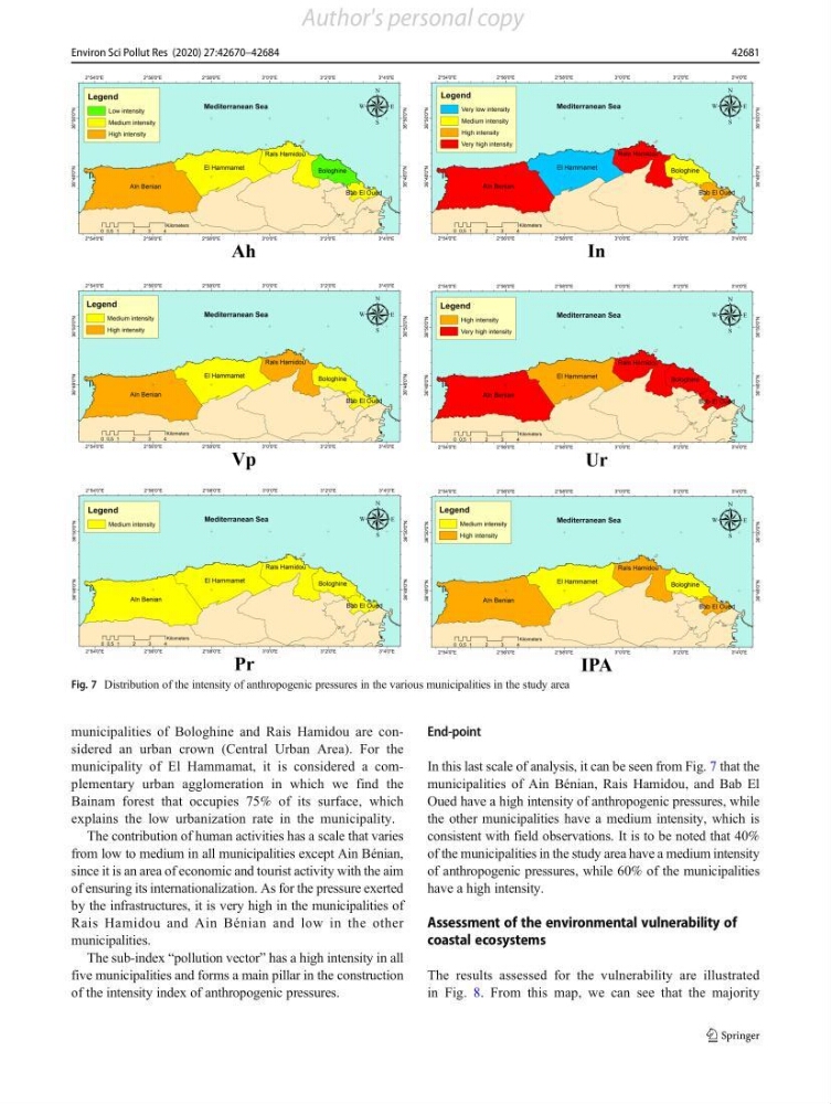
municipalities of Bologhine and Rais Hamidou are considered an urban crown (Central Urban Area). For the
municipality of El Hammamat, it is considered a complementary urban agglomeration in which we find the
Bainam forest that occupies 75% of its surface, which
explains the low urbanization rate in the municipality.
The contribution of human activities has a scale that varies
from low to medium in all municipalities except Ain Bénian,
since it is an area of economic and tourist activity with the aim
of ensuring its internationalization. As for the pressure exerted
by the infrastructures, it is very high in the municipalities of
Rais Hamidou and Ain Bénian and low in the other
municipalities.
The sub-index “pollution vector” has a high intensity in all
five municipalities and forms a main pillar in the construction
of the intensity index of anthropogenic pressures.
End-point
In this last scale of analysis, it can be seen from Fig. 7 that the
municipalities of Ain Bénian, Rais Hamidou, and Bab El
Oued have a high intensity of anthropogenic pressures, while
the other municipalities have a medium intensity, which is
consistent with field observations. It is to be noted that 40%
of the municipalities in the study area have a medium intensity
of anthropogenic pressures, while 60% of the municipalities
have a high intensity.
Assessment of the environmental vulnerability of
coastal ecosystems
The results assessed for the vulnerability are illustrated
in Fig. 8. From this map, we can see that the majority
Fig. 7 Distribution of the intensity of anthropogenic pressures in the various municipalities in the study area
42681
Environ Sci Pollut Res (2020) 27:42670–42684
Author's personal copy
municipality of El Hammamat, it is considered a complementary urban agglomeration in which we find the
Bainam forest that occupies 75% of its surface, which
explains the low urbanization rate in the municipality.
The contribution of human activities has a scale that varies
from low to medium in all municipalities except Ain Bénian,
since it is an area of economic and tourist activity with the aim
of ensuring its internationalization. As for the pressure exerted
by the infrastructures, it is very high in the municipalities of
Rais Hamidou and Ain Bénian and low in the other
municipalities.
The sub-index “pollution vector” has a high intensity in all
five municipalities and forms a main pillar in the construction
of the intensity index of anthropogenic pressures.
End-point
In this last scale of analysis, it can be seen from Fig. 7 that the
municipalities of Ain Bénian, Rais Hamidou, and Bab El
Oued have a high intensity of anthropogenic pressures, while
the other municipalities have a medium intensity, which is
consistent with field observations. It is to be noted that 40%
of the municipalities in the study area have a medium intensity
of anthropogenic pressures, while 60% of the municipalities
have a high intensity.
Assessment of the environmental vulnerability of
coastal ecosystems
The results assessed for the vulnerability are illustrated
in Fig. 8. From this map, we can see that the majority
Fig. 7 Distribution of the intensity of anthropogenic pressures in the various municipalities in the study area
42681
Environ Sci Pollut Res (2020) 27:42670–42684
Author's personal copy