

WORLD ATLAS OF CORAL REEFS
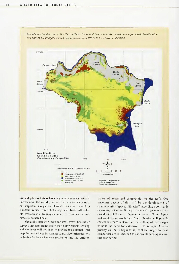
Broadscale habitat map of the Caicos Bank, Turks and Caicos Islands, based on a supervised classification
of Landsat TM imagery Ireproduced by permission of UNESCO, from Green et al 1200011.
Map derived from
Landsat TM imagery
Overall accuracy of map = 73%
Habitat type • User Accuraaes - A/ea (ha)
Land
MaCToalgae - 47% 45,603
Sand - 83% - 298,935
Coral reel - 86% - 92,306
Seagrass - 59% - 91 ,363
I
I
De«pWalef
ProJecJion UTM gnd zone 19
Spheroid Cladte 1886
Datum NA027 IBaliamas)
visual depth penetration than many remote sensing methods.
Furthennore, the inability of most sensors to detect small
but important navigational hazards Isuch as rocics 1 or
2 meters in size) mean that many new charts still utilize
old hydrographic techniques, often in combination with
remotely gathered data.
Generally speaking, even for small areas, boat-based
surveys are even more costly than using remote sensing,
and the latter will continue to provide the dominant reef
mapping techniques in coming years. New priorities will
undoubtedly be to increase resolution and the differentiation of zones and communities on the reefs. One
important aspect of this will be the development of
comprehensive "spectral libraries", providing a constantly
expanding reference library of spectral signatures associated with different reef communities at different depths
and in different conditions. Such libraries will provide
critical reference material for the truthing of new images
without the need for extensive field surveys. Another
priority will be to begin to utilize these images to make
comparisons over time, and to use remote sensing in coral
reef monitoring.
Broadscale habitat map of the Caicos Bank, Turks and Caicos Islands, based on a supervised classification
of Landsat TM imagery Ireproduced by permission of UNESCO, from Green et al 1200011.
Map derived from
Landsat TM imagery
Overall accuracy of map = 73%
Habitat type • User Accuraaes - A/ea (ha)
Land
MaCToalgae - 47% 45,603
Sand - 83% - 298,935
Coral reel - 86% - 92,306
Seagrass - 59% - 91 ,363
I
I
De«pWalef
ProJecJion UTM gnd zone 19
Spheroid Cladte 1886
Datum NA027 IBaliamas)
visual depth penetration than many remote sensing methods.
Furthennore, the inability of most sensors to detect small
but important navigational hazards Isuch as rocics 1 or
2 meters in size) mean that many new charts still utilize
old hydrographic techniques, often in combination with
remotely gathered data.
Generally speaking, even for small areas, boat-based
surveys are even more costly than using remote sensing,
and the latter will continue to provide the dominant reef
mapping techniques in coming years. New priorities will
undoubtedly be to increase resolution and the differentiation of zones and communities on the reefs. One
important aspect of this will be the development of
comprehensive "spectral libraries", providing a constantly
expanding reference library of spectral signatures associated with different reef communities at different depths
and in different conditions. Such libraries will provide
critical reference material for the truthing of new images
without the need for extensive field surveys. Another
priority will be to begin to utilize these images to make
comparisons over time, and to use remote sensing in coral
reef monitoring.