

Reef Mapping
Reef mapping techniques
Over
the years a wide array of mapping techniques
have been utilized to chart coral reefs. The choice
of techniques is clearly influenced by the primary
purpose for which a map is required, the scale of the work
and the availability of resources. This latter point is partly
a question of funds and personnel, but the availability of
resources and their costs have also changed considerably
over time. Many older maps were severely constrained by
the mapping techniques available, but for large areas of
the world these still remain the best available maps.
Ground surveying and mapping
On land, a variety of techniques have been widely applied
for ground surveying, from the very simple preparation of
hand sketches and chain surveying to more sophisticated
techniques of plane table surveying, geodetic surveying
and theodolite mapping. These techniques cannot easily
be applied to the coral reef environment, although it is
usually possible to gain information on distances from
shore of particular features, and also to carry out some
ground-based surveys on areas of very shallow reef flat
which may be exposed at low tide.
Historically, most marine mapping has relied on
boat-based surveys. One of the great challenges to such
surveys in the past has been the fixing of the boat's
position. It was of course possible to utilize existing maps
to establish position relative to known terrestrial features.
Far offshore, or in completely uncharted areas, however,
detailed astronomical methods were required to determine
absolute location, alongside careful measurement of
physical movement over shorter distances. Highly accurate positioning is now routinely available through the use
of Global Positioning Systems (GPS), which determine
position to within a few meters by linking position on the
ground to the known positions of a number of satellites.
The calculation of depth is another important element
in reef mapping. Prior to the development of sonar, this
was done using soundings. Long cables were lowered off
the edge of the boat until they hit the sea bed, at which
point the depth was measured. In many cases tallow was
placed in a small indentation in the bottom of the weight
at the base of the sounding line or cable and inspected on
return to the surface. This provided some indication of the
benthos: sand or mud, and occasionally pieces of coral
would adhere to this substance.
Although many of these techniques have now been
surpassed they cannot be ignored. For vast areas of the
world the only maps in existence were prepared using
these methods, and the great skills developed during the
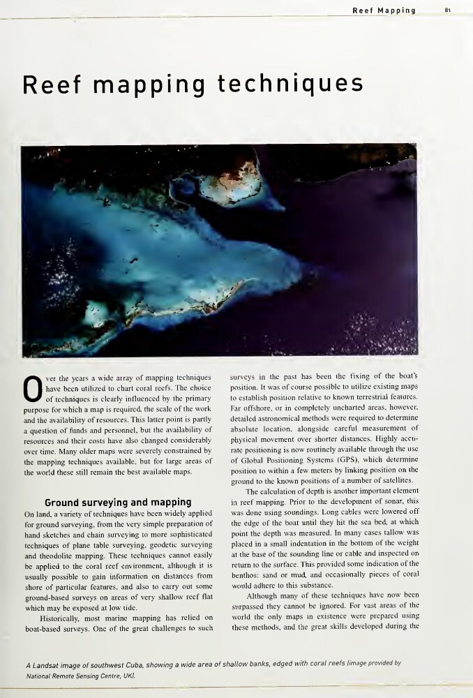
A Landsat image of southwest Cuba, showing a wide area of shallow banks, edged with coral reefs Image provided by
National Remote Sensing Centre. UK}.
Reef mapping techniques
Over
the years a wide array of mapping techniques
have been utilized to chart coral reefs. The choice
of techniques is clearly influenced by the primary
purpose for which a map is required, the scale of the work
and the availability of resources. This latter point is partly
a question of funds and personnel, but the availability of
resources and their costs have also changed considerably
over time. Many older maps were severely constrained by
the mapping techniques available, but for large areas of
the world these still remain the best available maps.
Ground surveying and mapping
On land, a variety of techniques have been widely applied
for ground surveying, from the very simple preparation of
hand sketches and chain surveying to more sophisticated
techniques of plane table surveying, geodetic surveying
and theodolite mapping. These techniques cannot easily
be applied to the coral reef environment, although it is
usually possible to gain information on distances from
shore of particular features, and also to carry out some
ground-based surveys on areas of very shallow reef flat
which may be exposed at low tide.
Historically, most marine mapping has relied on
boat-based surveys. One of the great challenges to such
surveys in the past has been the fixing of the boat's
position. It was of course possible to utilize existing maps
to establish position relative to known terrestrial features.
Far offshore, or in completely uncharted areas, however,
detailed astronomical methods were required to determine
absolute location, alongside careful measurement of
physical movement over shorter distances. Highly accurate positioning is now routinely available through the use
of Global Positioning Systems (GPS), which determine
position to within a few meters by linking position on the
ground to the known positions of a number of satellites.
The calculation of depth is another important element
in reef mapping. Prior to the development of sonar, this
was done using soundings. Long cables were lowered off
the edge of the boat until they hit the sea bed, at which
point the depth was measured. In many cases tallow was
placed in a small indentation in the bottom of the weight
at the base of the sounding line or cable and inspected on
return to the surface. This provided some indication of the
benthos: sand or mud, and occasionally pieces of coral
would adhere to this substance.
Although many of these techniques have now been
surpassed they cannot be ignored. For vast areas of the
world the only maps in existence were prepared using
these methods, and the great skills developed during the
A Landsat image of southwest Cuba, showing a wide area of shallow banks, edged with coral reefs Image provided by
National Remote Sensing Centre. UK}.