

310
WORLD ATLAS OF CORAL REEFS
Torres Strait and the Great
Barrier Reef
MAPS 11C, d and e
The
largest coral reef system in the world runs along
the northeastern coastline of Australia, stretching
from the Warrior Reefs in the northern Torres Strait
for well over 2 000 kilometers to the Capricorn-Bunker
group of reefs and islands in the south. Although many
of the reefs which make up this system form part
of a true barrier reef following the continental shelf on
its outermost edge, the Great Barrier Reef is actually a
highly complex system including nearly 3 000 separate
reefs and coral shoals, as well as high islands with fringing reef systems.
The origins of the Great Barrier Reef can largely be
traced back some 2 million years, when continental drift
brought the northern coastline of Australia into tropical
latitudes and some minor reef development began.
Widespread development is thought to be much more
recent, however, and can largely be traced back within
500 000 years, making it a much younger structure than
many oceanic atolls. As with coral reefs the world over,
periods of reef building were continually interrupted by
changes in climate and shifting sea levels. Typically reef
accretion was confined to relatively short periods of higher
sea level when reef structures began to build up on the
margins of the continental shelf As sea levels fell, the
reefs died, became land, and were subject to erosion forces
which in many places reduced their size again. High sea
levels returned and allowed new reef growth, typically
most prolific on the remaining structures of the earlier
reefs. At the present time in geological history, sea levels
are particularly high, such that the base of many of the
present reefs lies in depths unsuitable for active reef growth.
However, active reef building continues on the ancient
structures and the reef continues to thrive. The most recent
period of growth is probably only about 8 000 years.
Patterns of currents are complex across the Great
Barrier Reef One of the key driving forces is the South
Equatorial Current which flows across the Coral Sea from
the east. Where this meets the continental shelf it splits,
forming the weak, northward flowing Hiri Current north
of about 14°S and the southward flowing East Australia
Current further south. These currents induce localized
upwellings onto the shelf, and further have some influence
on the current patterns across the continental shelf,
although these are predominantly driven by prevailing
winds. For much of the year the southeast trade winds
predominate, driving northward flowing surface currents
in all areas, although most strongly north of about 20°S.
During the Northwest Monsoon (December-February)
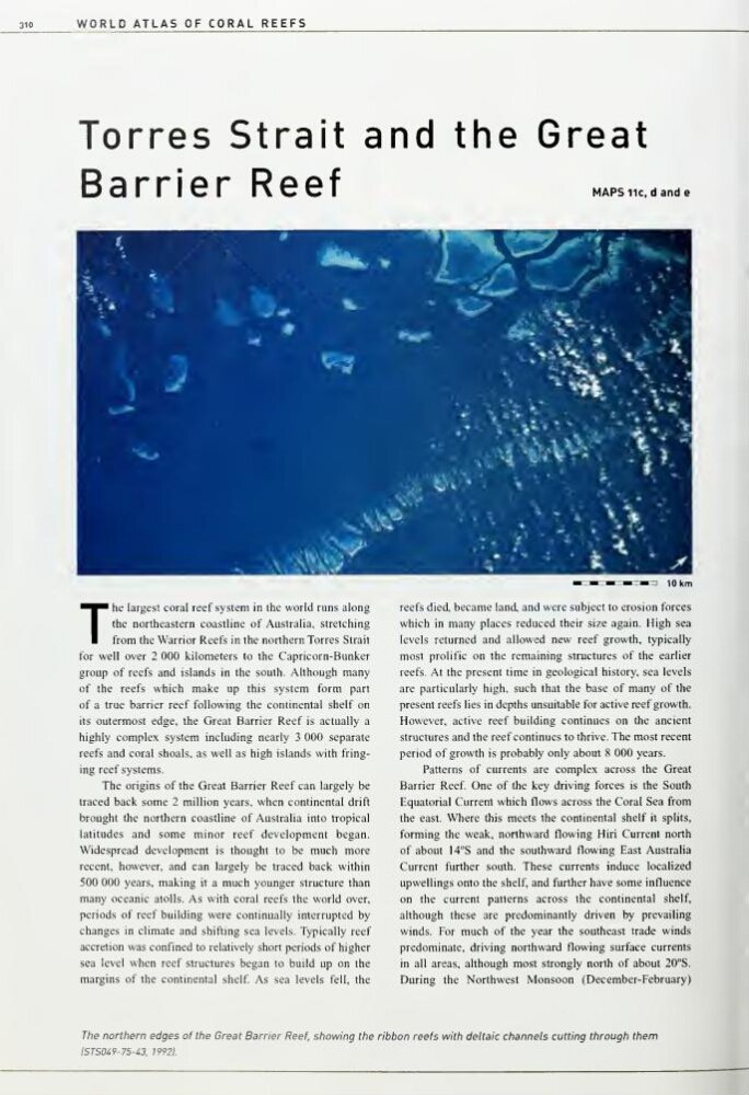
The northern edges of the Great Barrier Reef, showing the ribbon reefs with deltaic channels cutting through them
lSTS049-75-i3. 19921
WORLD ATLAS OF CORAL REEFS
Torres Strait and the Great
Barrier Reef
MAPS 11C, d and e
The
largest coral reef system in the world runs along
the northeastern coastline of Australia, stretching
from the Warrior Reefs in the northern Torres Strait
for well over 2 000 kilometers to the Capricorn-Bunker
group of reefs and islands in the south. Although many
of the reefs which make up this system form part
of a true barrier reef following the continental shelf on
its outermost edge, the Great Barrier Reef is actually a
highly complex system including nearly 3 000 separate
reefs and coral shoals, as well as high islands with fringing reef systems.
The origins of the Great Barrier Reef can largely be
traced back some 2 million years, when continental drift
brought the northern coastline of Australia into tropical
latitudes and some minor reef development began.
Widespread development is thought to be much more
recent, however, and can largely be traced back within
500 000 years, making it a much younger structure than
many oceanic atolls. As with coral reefs the world over,
periods of reef building were continually interrupted by
changes in climate and shifting sea levels. Typically reef
accretion was confined to relatively short periods of higher
sea level when reef structures began to build up on the
margins of the continental shelf As sea levels fell, the
reefs died, became land, and were subject to erosion forces
which in many places reduced their size again. High sea
levels returned and allowed new reef growth, typically
most prolific on the remaining structures of the earlier
reefs. At the present time in geological history, sea levels
are particularly high, such that the base of many of the
present reefs lies in depths unsuitable for active reef growth.
However, active reef building continues on the ancient
structures and the reef continues to thrive. The most recent
period of growth is probably only about 8 000 years.
Patterns of currents are complex across the Great
Barrier Reef One of the key driving forces is the South
Equatorial Current which flows across the Coral Sea from
the east. Where this meets the continental shelf it splits,
forming the weak, northward flowing Hiri Current north
of about 14°S and the southward flowing East Australia
Current further south. These currents induce localized
upwellings onto the shelf, and further have some influence
on the current patterns across the continental shelf,
although these are predominantly driven by prevailing
winds. For much of the year the southeast trade winds
predominate, driving northward flowing surface currents
in all areas, although most strongly north of about 20°S.
During the Northwest Monsoon (December-February)
The northern edges of the Great Barrier Reef, showing the ribbon reefs with deltaic channels cutting through them
lSTS049-75-i3. 19921