

194
WORLD ATLAS OF CORAL REEFS
Madagascar
MAP7d
Madagascar is one of the world's largest islands.
Along with the Indian sub-continent it was
separated off from the rest of Africa during the
Jurassic, and was then separated from the Indian subcontinent (and the granitic Seychelles) during the late
Jurassic/early Cretaceous. There are clear differences
between the physical conditions and resulting ecological
communities on the east and west coasts. The east coast is
steep and, in places, mountainous. This is matched by a
steeply shelving bathymetry and narrow continental shelf
The centra! and southern sections of this coast are dominated by vast sandy beaches and barrier islands and there is
no offshore reef development. Further north the coastline
becomes more complex, with a number of embayments and
rocky headlands as well as offshore islands. There are a
number of emergent fossil reefs along the more northerly
sections of this coastline. Active coral growth is also
widespread in the north, often growing on fossil structures
offshore, although not always contributing to active reef
accretion. There is a submerged and fragmented barrier
reef described off Toamasina, although the recent status of
this is unclear. Discontinuous fringing reefs also occur off
the coast around Foulpointe and Mananara, Nosy Boraha
(Sainte Marie Island), and the Masoala Peninsula.
The west coast consists of a wide coastal plain, with
numerous rivers, and also a wider continental shelf This
coast is swept by the northward flowing currents of the
Mozambique Gyre and is further affected by large tidal
ranges. Reef development is extensive in both the northern
and southern parts of this coast. The southernmost reefs are
offshore around Banc de I'Etoile and Nosy Manitsa. There
are extensive fringing reefs along much of the coast north of
Androka as far as Cap St. Vincent, varying between 500
meters and a few kilometers offshore, and separated from
the shore by a generally shallow channel. Around Tulear a
more complex system of offshore reefs is present, with
shoreline fringing communities, a series of inner lagoon
reefs, and a well developed barrier reef- the Grand Recifwhich runs continuously for 18 kilometers. Between the
Bale des Assassins and Morombe a sequence of reefs, many
with associated sand cays, has developed offshore, forming
a fragmented barrier reef system. This same barrier system
reappears north of the Mangoky Delta with a series of
submerged banks and emergent reefs with sand cays. Along
most of the central section of the west coa.st there is no reef
development, probably due to the terrigenous sediments
discharged from rivers. Offshore, however, there are reefs
towards the edge of the continental shelf associated with the
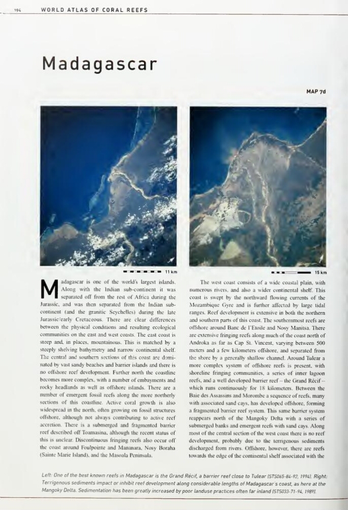
Left: One of the best known reefs In Madagascar Is the Grand Recif, a barrier reef close to Tulear ISTS065-84-92, 19941. Right:
Terrigenous sediments impact or inhibit reef development along considerable lengths of Madagascar's coast, as here at the
Mangoky Delta. Sedimentation has been greatly increased by poor landuse practices often far inland ISTS033-7I-94, 19891.
WORLD ATLAS OF CORAL REEFS
Madagascar
MAP7d
Madagascar is one of the world's largest islands.
Along with the Indian sub-continent it was
separated off from the rest of Africa during the
Jurassic, and was then separated from the Indian subcontinent (and the granitic Seychelles) during the late
Jurassic/early Cretaceous. There are clear differences
between the physical conditions and resulting ecological
communities on the east and west coasts. The east coast is
steep and, in places, mountainous. This is matched by a
steeply shelving bathymetry and narrow continental shelf
The centra! and southern sections of this coast are dominated by vast sandy beaches and barrier islands and there is
no offshore reef development. Further north the coastline
becomes more complex, with a number of embayments and
rocky headlands as well as offshore islands. There are a
number of emergent fossil reefs along the more northerly
sections of this coastline. Active coral growth is also
widespread in the north, often growing on fossil structures
offshore, although not always contributing to active reef
accretion. There is a submerged and fragmented barrier
reef described off Toamasina, although the recent status of
this is unclear. Discontinuous fringing reefs also occur off
the coast around Foulpointe and Mananara, Nosy Boraha
(Sainte Marie Island), and the Masoala Peninsula.
The west coast consists of a wide coastal plain, with
numerous rivers, and also a wider continental shelf This
coast is swept by the northward flowing currents of the
Mozambique Gyre and is further affected by large tidal
ranges. Reef development is extensive in both the northern
and southern parts of this coast. The southernmost reefs are
offshore around Banc de I'Etoile and Nosy Manitsa. There
are extensive fringing reefs along much of the coast north of
Androka as far as Cap St. Vincent, varying between 500
meters and a few kilometers offshore, and separated from
the shore by a generally shallow channel. Around Tulear a
more complex system of offshore reefs is present, with
shoreline fringing communities, a series of inner lagoon
reefs, and a well developed barrier reef- the Grand Recifwhich runs continuously for 18 kilometers. Between the
Bale des Assassins and Morombe a sequence of reefs, many
with associated sand cays, has developed offshore, forming
a fragmented barrier reef system. This same barrier system
reappears north of the Mangoky Delta with a series of
submerged banks and emergent reefs with sand cays. Along
most of the central section of the west coa.st there is no reef
development, probably due to the terrigenous sediments
discharged from rivers. Offshore, however, there are reefs
towards the edge of the continental shelf associated with the
Left: One of the best known reefs In Madagascar Is the Grand Recif, a barrier reef close to Tulear ISTS065-84-92, 19941. Right:
Terrigenous sediments impact or inhibit reef development along considerable lengths of Madagascar's coast, as here at the
Mangoky Delta. Sedimentation has been greatly increased by poor landuse practices often far inland ISTS033-7I-94, 19891.