

Eastern Caribbean and Atlantic
16S
reefs are those around the small islands of the Tobago
Cays. Each island has a fringing reef, the larger Horseshoe
Reef encircles them to the east, while beyond this there is
the larger World's End Reef The reefs of St. Vincent, and
particularly the Grenadines, support important fishing and
tourism, while large numbers of yachts visit these waters.
The Tobago Cays are particularly important, but their
condition has deteriorated recently because of storm
damage, white band disease, physical damage from fishing
gear and boat anchors, and pollution from visiting yachts.
in coral cover and diversity have been reported on offshore
reefs since the 1980s, linked to eutrophication from
urbanization and tourism developments.
Grenada
Grenada is the most southerly of the Lesser Antilles, and
the country also governs the southernmost islands of the
Grenadines. There are some fringing and patch reefs
around all the coasts of Grenada itself, although the total
Barbados
Barbados is, in many ways, an anomaly. It lies east of the
main Lesser Antilles chain in the Atlantic Ocean. Fringing
reefs are largely absent, although there is a small fringing
structure near Folkestone on the leeward west coast. There
are also sub-surface reefs along this coast, where a gently
sloping shelf extends about 300 meters seaward to a depth
of 10 meters. At the edge of the shelf, the sea floor drops
evenly to a depth of about 20 meters. Seaward from this
there are further submerged patch reef structures, together
with two larger bank barrier reefs, 12-20 meters deep and
up to 100 meters wide. Offshore, submerged bank barriers
are also found off the southeast coast. The eastern,
Atlantic, coast is subject to very high wave energies
throughout the year, and much of this coastline is a
bare carbonate platform extending out to deep water.
Nearshore reefs in Barbados have suffered considerably.
Reef flat corals disappeared over 100 years ago with the
intensification of agriculture, while considerable declines
^^^^^1
P^f Trinidad an d Tobago ^^^1
General Data
-
Population (thousands)
1 176
GDP ImiUion US$1
5 499
Land area (km^l
5 152
Marine area Ithousand km^ 1
lU
Per capita fish consumption Ikg/yearl
U
Status and Threats
Reefs at risk (%l
100
Recorded coral diseases
5
Biodiversity
Reef area Ikm^j
<100
Coral diversity
na/57
Mangrove area (km^l
>^^M
No. of nnangrove species
•m
No. of seagrass species
2
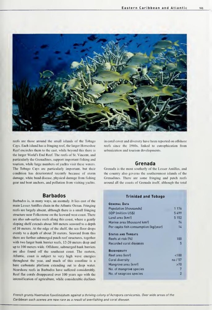
French grunts Haemulon flavolineatum against a thiriving colony of Acropora cervicornis. Over wide areas of thie
Caribbean such scenes are now rare as a result of overfishing and coral disease.
16S
reefs are those around the small islands of the Tobago
Cays. Each island has a fringing reef, the larger Horseshoe
Reef encircles them to the east, while beyond this there is
the larger World's End Reef The reefs of St. Vincent, and
particularly the Grenadines, support important fishing and
tourism, while large numbers of yachts visit these waters.
The Tobago Cays are particularly important, but their
condition has deteriorated recently because of storm
damage, white band disease, physical damage from fishing
gear and boat anchors, and pollution from visiting yachts.
in coral cover and diversity have been reported on offshore
reefs since the 1980s, linked to eutrophication from
urbanization and tourism developments.
Grenada
Grenada is the most southerly of the Lesser Antilles, and
the country also governs the southernmost islands of the
Grenadines. There are some fringing and patch reefs
around all the coasts of Grenada itself, although the total
Barbados
Barbados is, in many ways, an anomaly. It lies east of the
main Lesser Antilles chain in the Atlantic Ocean. Fringing
reefs are largely absent, although there is a small fringing
structure near Folkestone on the leeward west coast. There
are also sub-surface reefs along this coast, where a gently
sloping shelf extends about 300 meters seaward to a depth
of 10 meters. At the edge of the shelf, the sea floor drops
evenly to a depth of about 20 meters. Seaward from this
there are further submerged patch reef structures, together
with two larger bank barrier reefs, 12-20 meters deep and
up to 100 meters wide. Offshore, submerged bank barriers
are also found off the southeast coast. The eastern,
Atlantic, coast is subject to very high wave energies
throughout the year, and much of this coastline is a
bare carbonate platform extending out to deep water.
Nearshore reefs in Barbados have suffered considerably.
Reef flat corals disappeared over 100 years ago with the
intensification of agriculture, while considerable declines
^^^^^1
P^f Trinidad an d Tobago ^^^1
General Data
-
Population (thousands)
1 176
GDP ImiUion US$1
5 499
Land area (km^l
5 152
Marine area Ithousand km^ 1
lU
Per capita fish consumption Ikg/yearl
U
Status and Threats
Reefs at risk (%l
100
Recorded coral diseases
5
Biodiversity
Reef area Ikm^j
<100
Coral diversity
na/57
Mangrove area (km^l
>^^M
No. of nnangrove species
•m
No. of seagrass species
2
French grunts Haemulon flavolineatum against a thiriving colony of Acropora cervicornis. Over wide areas of thie
Caribbean such scenes are now rare as a result of overfishing and coral disease.