

Eastern Caribbean and Atlantic
153
Puerto Rico and
the Virgin Islands
MAP 6b
The
US Commonwealth of Puerto Rico is a large
mountainous island on the northern edge of the
Caribbean Sea, lying to the east of the Dominican
Republic. Mona Island is an uplifted carbonate island to
the west of the main island, while to the east there are two
other significant islands, those of Culebra and Vieques.
The Virgin Islands form an archipelago of about 100
islands to the east of Puerto Rico. The most western islands
are an "unincorporated territory" of the USA, the US
Virgin Islands, while those in the east are an overseas
territory of the UK, the British Virgin Islands. The majority
of these islands are on a single shallow platform which is
an extension of the Puerto Rico shelf. St. Croix to the south
lies on the separate Cruzan platform, separated by the
4 500 meter deep Virgin Islands Trough. To the northeast
this forms the deep, narrow Anegada Passage which
separates the Virgin Islands from the Lesser Antilles. North
of the Virgin Islands and Puerto Rico, the seismically
active Puerto Rico Trench constitutes the northern
boundary of the Caribbean tectonic plate, which is moving
at a rate of 2-4 centimeters per year in an easterly direction
with respect to the North American plate. The strike-slip
motion of this plate boundary has created a deep trench,
forming the deepest point in the Caribbean (8 605 meters)
at the Milwaukee Depth, some 150 kilometers north of
Mona Island. Puerto Rico and the rest of the Virgin Islands
are predominantly volcanic in origin, with the exception of
St. Croix and Anegada which, like Mona, were formed by
uplifted sedimentary rocks.
The dominant current flow is from east to west, with
water movement being driven by the Atlantic Northern
Equatorial Current. These islands also lie within the trade
wind belt, with wind blowing mainly from the east and
southeast during the summer months, and from the east
and northeast during the winter As a result of all these
factors, the prevailing swell is from the east, and sediment
transport is along the north and south margins.
Puerto Rico
Coral reefs are discontinuous around the main island of
Puerto Rico, and most abundant along the east, south and
west coasts. The offshore islands are more continuously
fringed by reefs. Coral cover is highly varied, and the
island includes some of the best developed and most
diverse coral reefs in the US Caribbean territories. As
elsewhere, coral disease has had a significant impact on
the total coral cover. The Diadema die-off was also
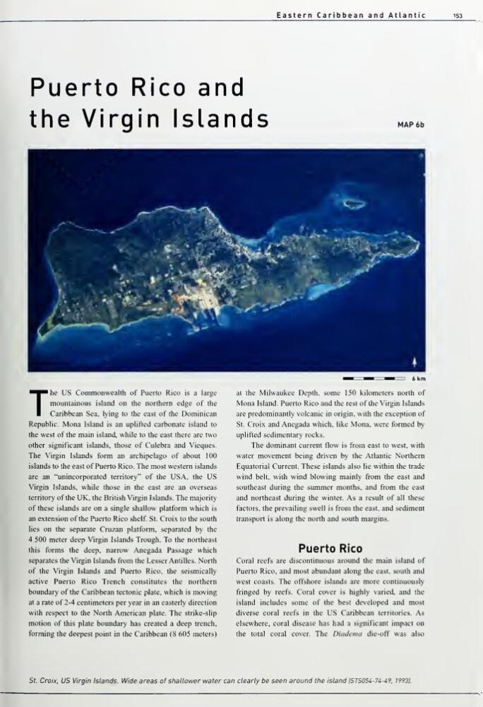
St. Croix. US Virgin Islands. Wide areas of sliatlower water can clearly be seen around ttie island IST5054-74-49. 19931.
153
Puerto Rico and
the Virgin Islands
MAP 6b
The
US Commonwealth of Puerto Rico is a large
mountainous island on the northern edge of the
Caribbean Sea, lying to the east of the Dominican
Republic. Mona Island is an uplifted carbonate island to
the west of the main island, while to the east there are two
other significant islands, those of Culebra and Vieques.
The Virgin Islands form an archipelago of about 100
islands to the east of Puerto Rico. The most western islands
are an "unincorporated territory" of the USA, the US
Virgin Islands, while those in the east are an overseas
territory of the UK, the British Virgin Islands. The majority
of these islands are on a single shallow platform which is
an extension of the Puerto Rico shelf. St. Croix to the south
lies on the separate Cruzan platform, separated by the
4 500 meter deep Virgin Islands Trough. To the northeast
this forms the deep, narrow Anegada Passage which
separates the Virgin Islands from the Lesser Antilles. North
of the Virgin Islands and Puerto Rico, the seismically
active Puerto Rico Trench constitutes the northern
boundary of the Caribbean tectonic plate, which is moving
at a rate of 2-4 centimeters per year in an easterly direction
with respect to the North American plate. The strike-slip
motion of this plate boundary has created a deep trench,
forming the deepest point in the Caribbean (8 605 meters)
at the Milwaukee Depth, some 150 kilometers north of
Mona Island. Puerto Rico and the rest of the Virgin Islands
are predominantly volcanic in origin, with the exception of
St. Croix and Anegada which, like Mona, were formed by
uplifted sedimentary rocks.
The dominant current flow is from east to west, with
water movement being driven by the Atlantic Northern
Equatorial Current. These islands also lie within the trade
wind belt, with wind blowing mainly from the east and
southeast during the summer months, and from the east
and northeast during the winter As a result of all these
factors, the prevailing swell is from the east, and sediment
transport is along the north and south margins.
Puerto Rico
Coral reefs are discontinuous around the main island of
Puerto Rico, and most abundant along the east, south and
west coasts. The offshore islands are more continuously
fringed by reefs. Coral cover is highly varied, and the
island includes some of the best developed and most
diverse coral reefs in the US Caribbean territories. As
elsewhere, coral disease has had a significant impact on
the total coral cover. The Diadema die-off was also
St. Croix. US Virgin Islands. Wide areas of sliatlower water can clearly be seen around ttie island IST5054-74-49. 19931.