

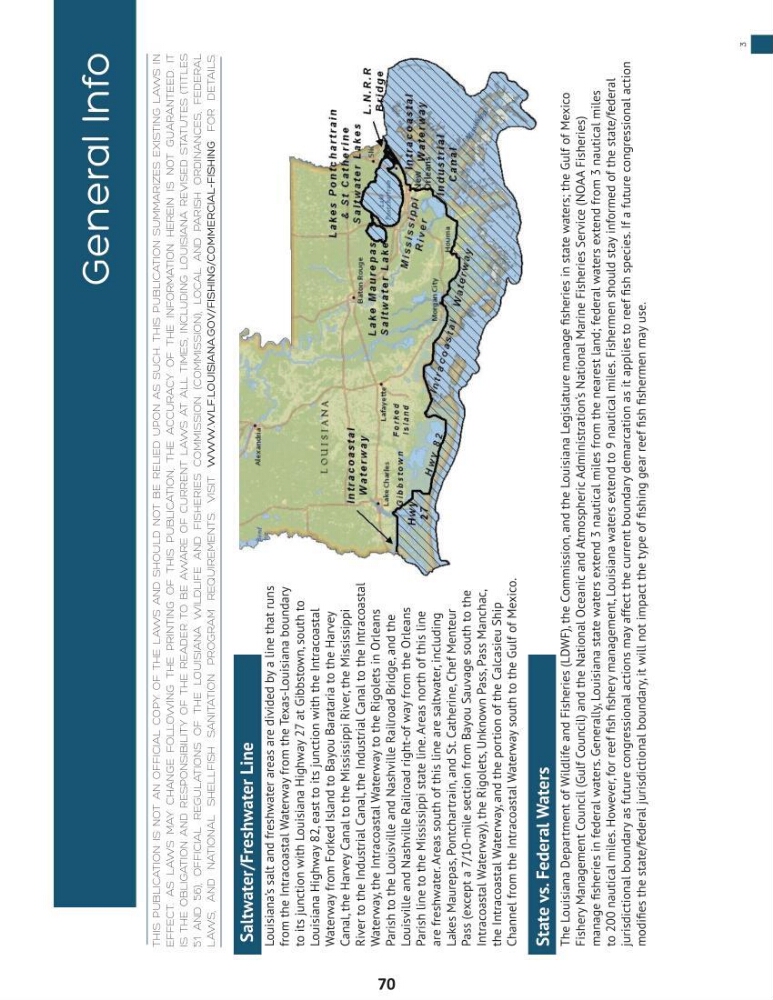
Saltwater/Freshwater Line
Louisiana’s salt and freshwater areas are divided by a line that runs
from the Intracoastal Waterway from the Texas-Louisiana boundary
to its junction with Louisiana Highway 27 at Gibbstown, south to
Louisiana Highway 82, east to its junction with the Intracoastal
Waterway from Forked Island to Bayou Barataria to the Harvey
Canal, the Harvey Canal to the Mississippi River, the Mississippi
River to the Industrial Canal, the Industrial Canal to the Intracoastal
Waterway, the Intracoastal Waterway to the Rigolets in Orleans
Parish to the Louisville and Nashville Railroad Bridge, and the
Louisville and Nashville Railroad right-of way from the Orleans
Parish line to the Mississippi state line. Areas north of this line
are freshwater. Areas south of this line are saltwater, including
Lakes Maurepas, Pontchartrain, and St. Catherine, Chef Menteur
Pass (except a 7/10-mile section from Bayou Sauvage south to the
Intracoastal Waterway), the Rigolets, Unknown Pass, Pass Manchac,
the Intracoastal Waterway, and the portion of the Calcasieu Ship
Channel from the Intracoastal Waterway south to the Gulf of Mexico.
State vs. Federal Waters
The Louisiana Department of Wildlife and Fisheries (LDWF), the Commission, and the Louisiana Legislature manage fisheries in state waters; the Gulf of Mexico
Fishery Management Council (Gulf Council) and the National Oceanic and Atmospheric Administration‘s National Marine Fisheries Service (NOAA Fisheries)
manage fisheries in federal waters. Generally, Louisiana state waters extend 3 nautical miles from the nearest land; federal waters extend from 3 nautical miles
to 200 nautical miles. However, for reef fish fishery management, Louisiana waters extend to 9 nautical miles. Fishermen should stay informed of the state/federal
jurisdictional boundary as future congressional actions may affect the current boundary demarcation as it applies to reef fish species. If a future congressional action
modifies the state/federal jurisdictional boundary, it will not impact the type of fishing gear reef fish fishermen may use.
General Info
THis publiCaTion is noT an oFFiCial Copy oF THe laws and sHould noT be Relied upon as suCH. THis publiCaTion summaRizes exisTing laws in
eFFeCT. as laws may CHange Following THe pRinTing oF THis publiCaTion, THe aCCuRaCy oF THe inFoRmaTion HeRein is noT guaRanTeed. iT
is THe obligaTion and ResponsibiliTy oF THe ReadeR To be awaRe oF CuRRenT laws aT all Times, inCluding louisiana Revised sTaTuTes (TiTles
51 and 56), oFFiCial RegulaTions oF THe louisiana wildliFe and FisHeRies Commission (Commission), loCal and paRisH oRdinanCes, FedeRal
laws, and naTional sHellFisH saniTaTion pRogRam RequiRemenTs. visiT WWW.WLF.LOuISIAnA.GOV/FISHInG/COMMeRCIAL-FISHInG
FoR deTails.
3
70
Louisiana’s salt and freshwater areas are divided by a line that runs
from the Intracoastal Waterway from the Texas-Louisiana boundary
to its junction with Louisiana Highway 27 at Gibbstown, south to
Louisiana Highway 82, east to its junction with the Intracoastal
Waterway from Forked Island to Bayou Barataria to the Harvey
Canal, the Harvey Canal to the Mississippi River, the Mississippi
River to the Industrial Canal, the Industrial Canal to the Intracoastal
Waterway, the Intracoastal Waterway to the Rigolets in Orleans
Parish to the Louisville and Nashville Railroad Bridge, and the
Louisville and Nashville Railroad right-of way from the Orleans
Parish line to the Mississippi state line. Areas north of this line
are freshwater. Areas south of this line are saltwater, including
Lakes Maurepas, Pontchartrain, and St. Catherine, Chef Menteur
Pass (except a 7/10-mile section from Bayou Sauvage south to the
Intracoastal Waterway), the Rigolets, Unknown Pass, Pass Manchac,
the Intracoastal Waterway, and the portion of the Calcasieu Ship
Channel from the Intracoastal Waterway south to the Gulf of Mexico.
State vs. Federal Waters
The Louisiana Department of Wildlife and Fisheries (LDWF), the Commission, and the Louisiana Legislature manage fisheries in state waters; the Gulf of Mexico
Fishery Management Council (Gulf Council) and the National Oceanic and Atmospheric Administration‘s National Marine Fisheries Service (NOAA Fisheries)
manage fisheries in federal waters. Generally, Louisiana state waters extend 3 nautical miles from the nearest land; federal waters extend from 3 nautical miles
to 200 nautical miles. However, for reef fish fishery management, Louisiana waters extend to 9 nautical miles. Fishermen should stay informed of the state/federal
jurisdictional boundary as future congressional actions may affect the current boundary demarcation as it applies to reef fish species. If a future congressional action
modifies the state/federal jurisdictional boundary, it will not impact the type of fishing gear reef fish fishermen may use.
General Info
THis publiCaTion is noT an oFFiCial Copy oF THe laws and sHould noT be Relied upon as suCH. THis publiCaTion summaRizes exisTing laws in
eFFeCT. as laws may CHange Following THe pRinTing oF THis publiCaTion, THe aCCuRaCy oF THe inFoRmaTion HeRein is noT guaRanTeed. iT
is THe obligaTion and ResponsibiliTy oF THe ReadeR To be awaRe oF CuRRenT laws aT all Times, inCluding louisiana Revised sTaTuTes (TiTles
51 and 56), oFFiCial RegulaTions oF THe louisiana wildliFe and FisHeRies Commission (Commission), loCal and paRisH oRdinanCes, FedeRal
laws, and naTional sHellFisH saniTaTion pRogRam RequiRemenTs. visiT WWW.WLF.LOuISIAnA.GOV/FISHInG/COMMeRCIAL-FISHInG
FoR deTails.
3
70