

216
14.3.4 Northern Route (Atlit → Naharayim-Bakura → Dead
Sea)
The distance from Atlit to Naharayim–Bakura is 65–70 km (Fig. 14.5 ). The possibility of conveying seawater along this route is ruled out because the course extends
over fertile valleys and sensitive aquifers, and the risk for damage from leakage is
high. Therefore, this alternative involves desalination along the Mediterranean coast
near Atlit and conveyance of the desalinated water (via pipeline) to Naharayim–
Bakura, where the Yarmuk fl ows into the Jordan River. The location of the eastern
outlet (Naharayim–Bakura) opens up opportunities to combine this option with partial restoration of the lower Jordan River; from Naharayim–Bakura, the water fl ows
along the lower Jordan River to the Dead Sea, performing a dual goal: partially
restoring the lower Jordan River and stabilising (or halting the decline of) the Dead
Sea level.
Allowing for a pumped storage reservoir near Kaukab-el-Houa (Belvoir), at
300 m elevation (more than 500 m above Naharayim–Bakura), and exploiting the
Israeli peak-load electricity tariffs to pump water during low demand (nights) and
generate hydropower during high demand, it was found that the profi t of the hydropower plant is suffi cient to cover the entire cost of conveying the desalinated water
2% Interest
4% Interest
6% Interest
MDS (Tunnel)
−0.05
0.02
0.09
RSDS (Tariff B)
0.1
0.16
0.22
−0.05
0.02
0.09
0.1
0.16
0.22
−0.10
−0.05
0.00
0.05
0.10
0.15
0.20
0.25
Cost [USD/m
3
]
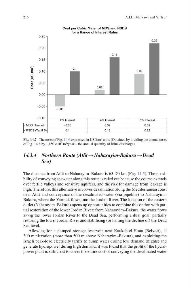
Cost per Cubic Meter of MDS and RSDS
for a Range of Interest Rates
Fig. 14.7 The costs of Fig. 14.6 expressed in USD/m
3 units (Obtained by dividing the annual costs
of Fig. 14.6 by 1,150 × 10
6 m
3 /year – the annual quantity of brine discharge)
A.I.H. Malkawi and Y. Tsur
14.3.4 Northern Route (Atlit → Naharayim-Bakura → Dead
Sea)
The distance from Atlit to Naharayim–Bakura is 65–70 km (Fig. 14.5 ). The possibility of conveying seawater along this route is ruled out because the course extends
over fertile valleys and sensitive aquifers, and the risk for damage from leakage is
high. Therefore, this alternative involves desalination along the Mediterranean coast
near Atlit and conveyance of the desalinated water (via pipeline) to Naharayim–
Bakura, where the Yarmuk fl ows into the Jordan River. The location of the eastern
outlet (Naharayim–Bakura) opens up opportunities to combine this option with partial restoration of the lower Jordan River; from Naharayim–Bakura, the water fl ows
along the lower Jordan River to the Dead Sea, performing a dual goal: partially
restoring the lower Jordan River and stabilising (or halting the decline of) the Dead
Sea level.
Allowing for a pumped storage reservoir near Kaukab-el-Houa (Belvoir), at
300 m elevation (more than 500 m above Naharayim–Bakura), and exploiting the
Israeli peak-load electricity tariffs to pump water during low demand (nights) and
generate hydropower during high demand, it was found that the profi t of the hydropower plant is suffi cient to cover the entire cost of conveying the desalinated water
2% Interest
4% Interest
6% Interest
MDS (Tunnel)
−0.05
0.02
0.09
RSDS (Tariff B)
0.1
0.16
0.22
−0.05
0.02
0.09
0.1
0.16
0.22
−0.10
−0.05
0.00
0.05
0.10
0.15
0.20
0.25
Cost [USD/m
3
]
Cost per Cubic Meter of MDS and RSDS
for a Range of Interest Rates
Fig. 14.7 The costs of Fig. 14.6 expressed in USD/m
3 units (Obtained by dividing the annual costs
of Fig. 14.6 by 1,150 × 10
6 m
3 /year – the annual quantity of brine discharge)
A.I.H. Malkawi and Y. Tsur