

bryophytes and species abundances. Additionally, selected environmental factors
like ground and air temperatures, humidity, precipitation amount, water level, and
pH-values are measured. The number of tree species is counted in all sample units
along !100 m long transects. Sampling should take place between June and
August. To avoid human impacts by monitoring, vegetation and environmental
monitoring will proceed in 3–5 year intervals. To detect changes of environmental
conditions we applied also indirect phyto-indication methods, i.e. Ellenberg indicator values, which in many situations reflect habitat quality rather well (Diekmann
2003; Ellenberg et al. 2001).
With the help of remote sensing applications, using aerial photography, it will be
possible to monitor the distribution and extension of peat bog habitats on the
landscape scale and to monitor broad-scale changes (succession) in habitats. Additionally, field survey is required for habitats that are difficult to identify from the
photographs (Birnie et al. 2010; Ploompuu 2005).
To detect human impacts, (1) the presence of grazing in the direct vicinity of
bogs will be noted, and (2) air pollution will be monitored by mapping epiphytic
lichen vegetation in the forests around peatland ecosystems (Batic ˇ and Kralj 1995).
(3) With regard to the impact of winter salting of roads in the direct vicinity of bogs,
analyses of snow and soil samples, and analysis of the spruce needles will be
provided (C ˇ otar 2010; Le Roux et al. 2005; Levanic ˇ and Oven 2002).
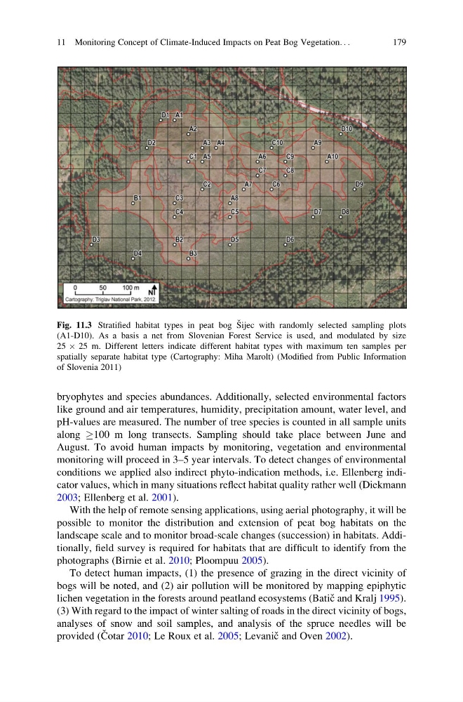
Fig. 11.3 Stratified habitat types in peat bog S ˇ ijec with randomly selected sampling plots
(A1-D10). As a basis a net from Slovenian Forest Service is used, and modulated by size
25 Â 25 m. Different letters indicate different habitat types with maximum ten samples per
spatially separate habitat type (Cartography: Miha Marolt) (Modified from Public Information
of Slovenia 2011)
11 Monitoring Concept of Climate-Induced Impacts on Peat Bog Vegetation. . .
179
like ground and air temperatures, humidity, precipitation amount, water level, and
pH-values are measured. The number of tree species is counted in all sample units
along !100 m long transects. Sampling should take place between June and
August. To avoid human impacts by monitoring, vegetation and environmental
monitoring will proceed in 3–5 year intervals. To detect changes of environmental
conditions we applied also indirect phyto-indication methods, i.e. Ellenberg indicator values, which in many situations reflect habitat quality rather well (Diekmann
2003; Ellenberg et al. 2001).
With the help of remote sensing applications, using aerial photography, it will be
possible to monitor the distribution and extension of peat bog habitats on the
landscape scale and to monitor broad-scale changes (succession) in habitats. Additionally, field survey is required for habitats that are difficult to identify from the
photographs (Birnie et al. 2010; Ploompuu 2005).
To detect human impacts, (1) the presence of grazing in the direct vicinity of
bogs will be noted, and (2) air pollution will be monitored by mapping epiphytic
lichen vegetation in the forests around peatland ecosystems (Batic ˇ and Kralj 1995).
(3) With regard to the impact of winter salting of roads in the direct vicinity of bogs,
analyses of snow and soil samples, and analysis of the spruce needles will be
provided (C ˇ otar 2010; Le Roux et al. 2005; Levanic ˇ and Oven 2002).
Fig. 11.3 Stratified habitat types in peat bog S ˇ ijec with randomly selected sampling plots
(A1-D10). As a basis a net from Slovenian Forest Service is used, and modulated by size
25 Â 25 m. Different letters indicate different habitat types with maximum ten samples per
spatially separate habitat type (Cartography: Miha Marolt) (Modified from Public Information
of Slovenia 2011)
11 Monitoring Concept of Climate-Induced Impacts on Peat Bog Vegetation. . .
179