

maize crops then covered the soil surface. Summarizing the impacts of the different
erosion influencing factors by using the RUSLE equation (Cong 2011), the Muong
Lum site revealed a moderate mean soil loss of 16.3 t ha
À1 year
À1 , whereas Chieng
Khoi revealed a moderate to high rate of 52 t ha
À1 year
À1 (see Table 2.16c). This
was despite the fact that the proportion of very steep slopes, those with peak soil
losses of up to 140 t ha
À1 year
À1 , were much higher in Muong Lum. The high
proportion of maize and cassava crops cultivated in Chieng Khoi, when compared
to Muong Lum, explained this pattern, as these crops were being cultivated
exclusively on sloping and steep land, contributing 57 (maize) and 147 (cassava)
t ha
À1 year
À1 to overall soil losses. The measurement of soil erosion involves an
elaborate process which is subject to methodological limitations and shows a huge
variation in space and time, and Dung et al. (2008), in north-west Vietnam,
measured an average of 20 t ha
À1 year
À1 of erosion in years when fields were
cropped, while under secondary forest (fallow) the erosion rates were mostly in the
range <1 t ha
À1 year
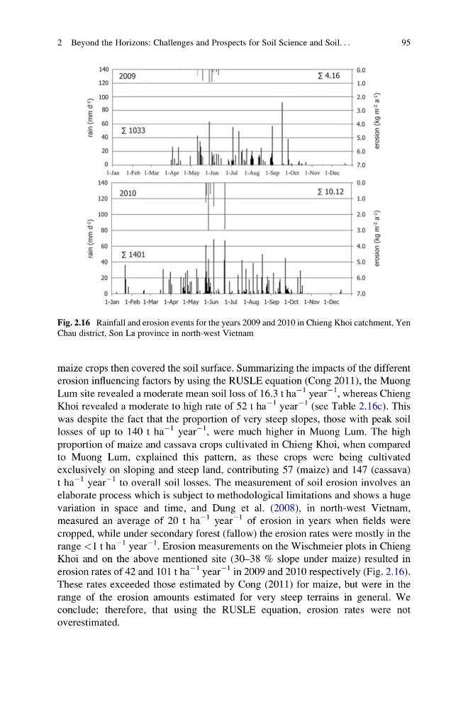
À1 . Erosion measurements on the Wischmeier plots in Chieng
Khoi and on the above mentioned site (30–38 % slope under maize) resulted in
erosion rates of 42 and 101 t ha
À1 year
À1 in 2009 and 2010 respectively (Fig. 2.16).
These rates exceeded those estimated by Cong (2011) for maize, but were in the
range of the erosion amounts estimated for very steep terrains in general. We
conclude; therefore, that using the RUSLE equation, erosion rates were not
overestimated.
Fig. 2.16 Rainfall and erosion events for the years 2009 and 2010 in Chieng Khoi catchment, Yen
Chau district, Son La province in north-west Vietnam
2 Beyond the Horizons: Challenges and Prospects for Soil Science and Soil. . .
95
erosion influencing factors by using the RUSLE equation (Cong 2011), the Muong
Lum site revealed a moderate mean soil loss of 16.3 t ha
À1 year
À1 , whereas Chieng
Khoi revealed a moderate to high rate of 52 t ha
À1 year
À1 (see Table 2.16c). This
was despite the fact that the proportion of very steep slopes, those with peak soil
losses of up to 140 t ha
À1 year
À1 , were much higher in Muong Lum. The high
proportion of maize and cassava crops cultivated in Chieng Khoi, when compared
to Muong Lum, explained this pattern, as these crops were being cultivated
exclusively on sloping and steep land, contributing 57 (maize) and 147 (cassava)
t ha
À1 year
À1 to overall soil losses. The measurement of soil erosion involves an
elaborate process which is subject to methodological limitations and shows a huge
variation in space and time, and Dung et al. (2008), in north-west Vietnam,
measured an average of 20 t ha
À1 year
À1 of erosion in years when fields were
cropped, while under secondary forest (fallow) the erosion rates were mostly in the
range <1 t ha
À1 year
À1 . Erosion measurements on the Wischmeier plots in Chieng
Khoi and on the above mentioned site (30–38 % slope under maize) resulted in
erosion rates of 42 and 101 t ha
À1 year
À1 in 2009 and 2010 respectively (Fig. 2.16).
These rates exceeded those estimated by Cong (2011) for maize, but were in the
range of the erosion amounts estimated for very steep terrains in general. We
conclude; therefore, that using the RUSLE equation, erosion rates were not
overestimated.
Fig. 2.16 Rainfall and erosion events for the years 2009 and 2010 in Chieng Khoi catchment, Yen
Chau district, Son La province in north-west Vietnam
2 Beyond the Horizons: Challenges and Prospects for Soil Science and Soil. . .
95