

56
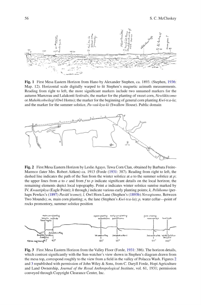
Fig. 1 First Mesa Eastern Horizon from Hano by Alexander Stephen, ca. 1893. (Stephen, 1936:
Map. 12). Horizontal scale digitally warped to fit Stephen’s magnetic azimuth measurements.
Reading from right to left, the more significant markers include two unnamed markers for the
autumn Mamzrau and Lalakonti festivals; the marker for the planting of sweet corn, Nevéûktcomo
or Mahóñceñwilegĭ (Owl Horns); the marker for the beginning of general corn planting Kwí-tca-la;
and the marker for the summer solstice, Pa-vaú-kya-ki (Swallow House). Public domain
Fig. 2 First Mesa Eastern Horizon by Leslie Agayo, Tewa Corn Clan, obtained by Barbara FreireMarreco (later Mrs. Robert Aitken) ca. 1913 (Forde (1931: 387). Reading from right to left, the
dashed line indicates the path of the Sun from the winter solstice at a to the summer solstice at p;
the upper lines from a to c and from f to p indicate significant details on the local horizon; the
remaining elements depict local topography. Point a indicates winter solstice sunrise marked by
IV, Kwaatipkya (Eagle Point); h through j indicate various early planting points; k, Pelühomo (perhaps Fewkes’s (1897) Pavüñ’tcomo); l, Owl Horn Lane (Stephen’s (1893b) Neveqtsomo, Between
Two Mounds); m, main corn planting; n, the lane (Stephen’s Kwí-tca-la); p, water cellar—point of
rocks promontory, summer solstice position
Fig. 3 First Mesa Eastern Horizon from the Valley Floor (Forde, 1931: 386). The horizon details,
which contrast significantly with the Sun-watcher’s view shown in Stephen’s diagram drawn from
the mesa top, correspond roughly to the view from a field in the valley of Polacca Wash. Figures 2
and 3 republished with permission of John Wiley & Sons, from C. Daryll Forde, Hopi Agriculture
and Land Ownership, Journal of the Royal Anthropological Institute, vol. 61, 1931; permission
conveyed through Copyright Clearance Center, Inc.
S. C. McCluskey
Fig. 1 First Mesa Eastern Horizon from Hano by Alexander Stephen, ca. 1893. (Stephen, 1936:
Map. 12). Horizontal scale digitally warped to fit Stephen’s magnetic azimuth measurements.
Reading from right to left, the more significant markers include two unnamed markers for the
autumn Mamzrau and Lalakonti festivals; the marker for the planting of sweet corn, Nevéûktcomo
or Mahóñceñwilegĭ (Owl Horns); the marker for the beginning of general corn planting Kwí-tca-la;
and the marker for the summer solstice, Pa-vaú-kya-ki (Swallow House). Public domain
Fig. 2 First Mesa Eastern Horizon by Leslie Agayo, Tewa Corn Clan, obtained by Barbara FreireMarreco (later Mrs. Robert Aitken) ca. 1913 (Forde (1931: 387). Reading from right to left, the
dashed line indicates the path of the Sun from the winter solstice at a to the summer solstice at p;
the upper lines from a to c and from f to p indicate significant details on the local horizon; the
remaining elements depict local topography. Point a indicates winter solstice sunrise marked by
IV, Kwaatipkya (Eagle Point); h through j indicate various early planting points; k, Pelühomo (perhaps Fewkes’s (1897) Pavüñ’tcomo); l, Owl Horn Lane (Stephen’s (1893b) Neveqtsomo, Between
Two Mounds); m, main corn planting; n, the lane (Stephen’s Kwí-tca-la); p, water cellar—point of
rocks promontory, summer solstice position
Fig. 3 First Mesa Eastern Horizon from the Valley Floor (Forde, 1931: 386). The horizon details,
which contrast significantly with the Sun-watcher’s view shown in Stephen’s diagram drawn from
the mesa top, correspond roughly to the view from a field in the valley of Polacca Wash. Figures 2
and 3 republished with permission of John Wiley & Sons, from C. Daryll Forde, Hopi Agriculture
and Land Ownership, Journal of the Royal Anthropological Institute, vol. 61, 1931; permission
conveyed through Copyright Clearance Center, Inc.
S. C. McCluskey