

177
To summarize, the megaliths in this area south of Sierra de Cantabria, a boundary
region between the Ebro valley, the Basque Country and the Duero plateau to the
west, appear as a coherent group with the orientation of most burial sites towards
south. The prevailing winds and the local orography do not seem to fully explain the
coherence of these orientations. We could perhaps suspect that the local topography
together with some astronomical features could provide clues to interpret the area as
a particularly sacred region for the local population. But, how does this compare to
other neighbouring and contemporary areas?
5 In Context of the Other Megaliths in the Area
If we compare the orientation of the megalithic monuments in this group with others
in the neighbourhood, we can verify that the norm in most areas next to the Rioja
Alavesa is to be facing towards the east or southeast, and certainly, in most cases
they can be related to Hoskin’s sunrise customs.
The closest group to Hechicera would be the few passage graves to the other side
of the Ebro valley, on the slopes of Sierra de Cameros that serves as a natural communication route between the Ebro and Duero valleys. Their date is almost contemporaneous to the Hechicera group with possible re-occupations during the Bell
Beaker phase (Pérez Arrondo, 1983; see Fig. 6).
Other groups include those to the other side of the Sierra de Cantabria to the
north, in the province of Alava; those to the north of the Burgos province, in the
Sedano area, also in the Ebro valley. To the east, we could mention those in the
southern parts of the pre-mountains of Navarra and Huesca, which are closer to the
Ebro valley than other megalithic monuments of those provinces in the Pyrenees
(Fig. 6; most data was obtained from Hoskin, 2001. A few new measurements are
included in Table 2).
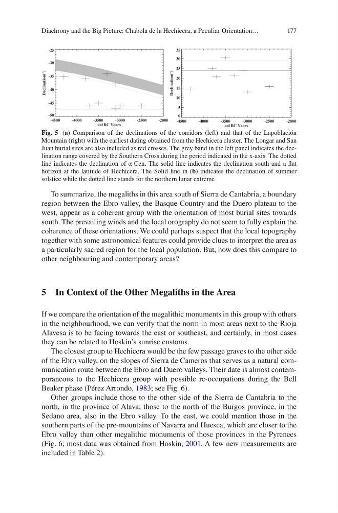
Fig. 5 (a) Comparison of the declinations of the corridors (left) and that of the Lapoblación
Mountain (right) with the earliest dating obtained from the Hechicera cluster. The Longar and San
Juan burial sites are also included as red crosses. The grey band in the left panel indicates the declination range covered by the Southern Cross during the period indicated in the x-axis. The dotted
line indicates the declination of α Cen. The solid line indicates the declination south and a flat
horizon at the latitude of Hechicera. The Solid line in (b) indicates the declination of summer
solstice while the dotted line stands for the northern lunar extreme
Diachrony and the Big Picture: Chabola de la Hechicera, a Peculiar Orientation…
To summarize, the megaliths in this area south of Sierra de Cantabria, a boundary
region between the Ebro valley, the Basque Country and the Duero plateau to the
west, appear as a coherent group with the orientation of most burial sites towards
south. The prevailing winds and the local orography do not seem to fully explain the
coherence of these orientations. We could perhaps suspect that the local topography
together with some astronomical features could provide clues to interpret the area as
a particularly sacred region for the local population. But, how does this compare to
other neighbouring and contemporary areas?
5 In Context of the Other Megaliths in the Area
If we compare the orientation of the megalithic monuments in this group with others
in the neighbourhood, we can verify that the norm in most areas next to the Rioja
Alavesa is to be facing towards the east or southeast, and certainly, in most cases
they can be related to Hoskin’s sunrise customs.
The closest group to Hechicera would be the few passage graves to the other side
of the Ebro valley, on the slopes of Sierra de Cameros that serves as a natural communication route between the Ebro and Duero valleys. Their date is almost contemporaneous to the Hechicera group with possible re-occupations during the Bell
Beaker phase (Pérez Arrondo, 1983; see Fig. 6).
Other groups include those to the other side of the Sierra de Cantabria to the
north, in the province of Alava; those to the north of the Burgos province, in the
Sedano area, also in the Ebro valley. To the east, we could mention those in the
southern parts of the pre-mountains of Navarra and Huesca, which are closer to the
Ebro valley than other megalithic monuments of those provinces in the Pyrenees
(Fig. 6; most data was obtained from Hoskin, 2001. A few new measurements are
included in Table 2).
Fig. 5 (a) Comparison of the declinations of the corridors (left) and that of the Lapoblación
Mountain (right) with the earliest dating obtained from the Hechicera cluster. The Longar and San
Juan burial sites are also included as red crosses. The grey band in the left panel indicates the declination range covered by the Southern Cross during the period indicated in the x-axis. The dotted
line indicates the declination of α Cen. The solid line indicates the declination south and a flat
horizon at the latitude of Hechicera. The Solid line in (b) indicates the declination of summer
solstice while the dotted line stands for the northern lunar extreme
Diachrony and the Big Picture: Chabola de la Hechicera, a Peculiar Orientation…