

river basins (Indus, Ganges, Brahmaputra, Salween and
Mekong rivers) for the near future following the moderate
RCP4.5 scenario. Despite differences in run-off composition,
they noted an increase in the projected run-off by 2050
caused primarily by an increase in precipitation in the upper
Ganges, Brahmaputra, Salween and Mekong Basins and
from the accelerated glacier melt in the upper Indus Basin
(Fig. 1 in Lutz et al. 2014).
Integrated glaciological studies in the Chandra River
basin, located in the monsoon-arid transition zone of the
Upper Indus, led by the National Centre for Polar and Ocean
Research (NCPOR) have provided valuable information for
understanding glacier retreat and its variability in the Western Himalayas. As part of this activity, a detailed glacier
mass/energy/water balance of five glaciers, viz. Sutri Dhaka,
Batal, Bara Shigri, Samundra Tapu and Gepang, has been
studied since 2014. While these glaciers are in similar geographical disposition, they exhibit comparatively different
characteristics such as debris cover, aspect and size. The
glaciers with high debris cover and varying thickness (e.g.
Batal Glacier) revealed low surface melting under debris
cover, as compared to clean ice and thin debris-covered ice
(e.g. Sutri Dhaka) (Sharma et al. 2016). The thickness (2–
100 cm) of debris has attenuated melting rates up to 70% of
total melting, and debris cover of <2 cm thickness has
accelerated melting up to 10% of the total melting (Patel
et al. 2016). Further, the role of air temperature was evident
with higher melting rate (*80% of total yearly melt) during
the short summers (Pratap et al. 2019). Moisture source for
precipitation over the study region is dominantly (>70%)
derived from the Mediterranean regions by western disturbances (WDs) during winter and early spring, with minor
(<20%) contributions from the Indian Summer Monsoon
(ISM) during the summer monsoon season (June–September). A three-component hydrograph separation based on
oxygen isotope fingerprinting and field-based ablation
measurements for one of the glacier basin (Sutri Dhaka)
revealed that glacier ice melting is the dominant (65–80%)
contributor to the river water, followed by snow melt (20–
35%) (Singh et al. 2019). Spatial mass balance gradient
varied with specific glacier’s location and topography.
Results of six years (2014–19) of in situ mass balance
observation by NCPOR in this basin show a dominantly
negative mass balance (−0.45 ± 0.09 to −1.37 ± 0.27 m
water equivalent per year), with the glacier snout retreating
at a rate of 13–33 m per year (NCPOR, unpublished data).
It is noteworthy to mention that regions in the Karakoram
Himalayas have experienced relatively stable glacier behaviour in recent decades, as opposed to glacier shrinkage
observed in many other places (Hewitt 2005; Gardelle et al.
2012; Kapnick et al. 2014; Kääb et al. 2015; Forsythe et al.
2017). Climate model simulations indicate that changes in
non-monsoonal wintertime frozen precipitation over the
Karakoram Himalayas appear to possibly shield this region
from significant glacier thickness losses under warming
climate (Kapnick et al. 2014; Kääb et al. 2015; Krishnan
et al. 2019a). Robust assessments of future projections of
precipitation and snowfall over the Western and Karakoram
Himalayas need further research given the inherent complexities of the HKH region and large uncertainties in model
projections over this region (Forsythe et al. 2017; Ridley
et al. 2013).
11.6 Knowledge Gaps
The accelerated anthropogenic warming over this
ice-covered mountain peaks and valleys of the HKH have
profound impacts such as loss in glacier mass and snow
cover which can directly affect agriculture food production.
Enhanced glacier mass loss can cause increased streamflow
and flooding of the Himalayan river basins, and further affect
downstream agricultural activity. Current generation climate
models and downscaling methodologies have limitations in
capturing the observed hydroclimatic variations of the
Himalayan river basins (Hasson et al. 2014, 2018).
Increases in snowmelt can also result from deposition of
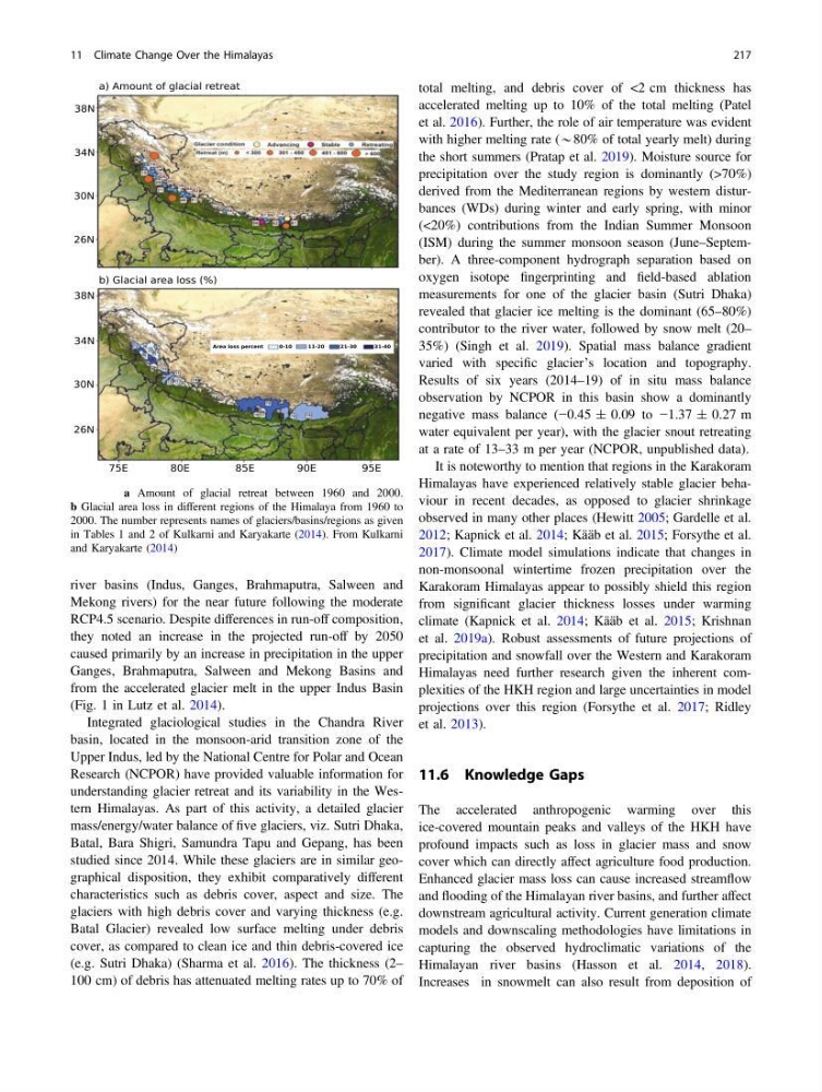
Fig. 11.8 a Amount of glacial retreat between 1960 and 2000.
b Glacial area loss in different regions of the Himalaya from 1960 to
2000. The number represents names of glaciers/basins/regions as given
in Tables 1 and 2 of Kulkarni and Karyakarte (2014). From Kulkarni
and Karyakarte (2014)
11 Climate Change Over the Himalayas
217
Mekong rivers) for the near future following the moderate
RCP4.5 scenario. Despite differences in run-off composition,
they noted an increase in the projected run-off by 2050
caused primarily by an increase in precipitation in the upper
Ganges, Brahmaputra, Salween and Mekong Basins and
from the accelerated glacier melt in the upper Indus Basin
(Fig. 1 in Lutz et al. 2014).
Integrated glaciological studies in the Chandra River
basin, located in the monsoon-arid transition zone of the
Upper Indus, led by the National Centre for Polar and Ocean
Research (NCPOR) have provided valuable information for
understanding glacier retreat and its variability in the Western Himalayas. As part of this activity, a detailed glacier
mass/energy/water balance of five glaciers, viz. Sutri Dhaka,
Batal, Bara Shigri, Samundra Tapu and Gepang, has been
studied since 2014. While these glaciers are in similar geographical disposition, they exhibit comparatively different
characteristics such as debris cover, aspect and size. The
glaciers with high debris cover and varying thickness (e.g.
Batal Glacier) revealed low surface melting under debris
cover, as compared to clean ice and thin debris-covered ice
(e.g. Sutri Dhaka) (Sharma et al. 2016). The thickness (2–
100 cm) of debris has attenuated melting rates up to 70% of
total melting, and debris cover of <2 cm thickness has
accelerated melting up to 10% of the total melting (Patel
et al. 2016). Further, the role of air temperature was evident
with higher melting rate (*80% of total yearly melt) during
the short summers (Pratap et al. 2019). Moisture source for
precipitation over the study region is dominantly (>70%)
derived from the Mediterranean regions by western disturbances (WDs) during winter and early spring, with minor
(<20%) contributions from the Indian Summer Monsoon
(ISM) during the summer monsoon season (June–September). A three-component hydrograph separation based on
oxygen isotope fingerprinting and field-based ablation
measurements for one of the glacier basin (Sutri Dhaka)
revealed that glacier ice melting is the dominant (65–80%)
contributor to the river water, followed by snow melt (20–
35%) (Singh et al. 2019). Spatial mass balance gradient
varied with specific glacier’s location and topography.
Results of six years (2014–19) of in situ mass balance
observation by NCPOR in this basin show a dominantly
negative mass balance (−0.45 ± 0.09 to −1.37 ± 0.27 m
water equivalent per year), with the glacier snout retreating
at a rate of 13–33 m per year (NCPOR, unpublished data).
It is noteworthy to mention that regions in the Karakoram
Himalayas have experienced relatively stable glacier behaviour in recent decades, as opposed to glacier shrinkage
observed in many other places (Hewitt 2005; Gardelle et al.
2012; Kapnick et al. 2014; Kääb et al. 2015; Forsythe et al.
2017). Climate model simulations indicate that changes in
non-monsoonal wintertime frozen precipitation over the
Karakoram Himalayas appear to possibly shield this region
from significant glacier thickness losses under warming
climate (Kapnick et al. 2014; Kääb et al. 2015; Krishnan
et al. 2019a). Robust assessments of future projections of
precipitation and snowfall over the Western and Karakoram
Himalayas need further research given the inherent complexities of the HKH region and large uncertainties in model
projections over this region (Forsythe et al. 2017; Ridley
et al. 2013).
11.6 Knowledge Gaps
The accelerated anthropogenic warming over this
ice-covered mountain peaks and valleys of the HKH have
profound impacts such as loss in glacier mass and snow
cover which can directly affect agriculture food production.
Enhanced glacier mass loss can cause increased streamflow
and flooding of the Himalayan river basins, and further affect
downstream agricultural activity. Current generation climate
models and downscaling methodologies have limitations in
capturing the observed hydroclimatic variations of the
Himalayan river basins (Hasson et al. 2014, 2018).
Increases in snowmelt can also result from deposition of
Fig. 11.8 a Amount of glacial retreat between 1960 and 2000.
b Glacial area loss in different regions of the Himalaya from 1960 to
2000. The number represents names of glaciers/basins/regions as given
in Tables 1 and 2 of Kulkarni and Karyakarte (2014). From Kulkarni
and Karyakarte (2014)
11 Climate Change Over the Himalayas
217