

ISM months, and the cloudburst events are found to have a
dynamical sequence of convective triggering followed by
orographic locking mechanisms (Dimri et al. 2017).
Figure 8.7 shows distribution of cloudburst (rainfall rate
exceeding 100 mm h
−1 ) and mini-cloudburst (rainfall in
consecutive 2 h exceed 5 cm) events over the Indian
subcontinent during the period 1969–2015. Based on the
information from 126 station observations during this period,
on an average, the Indian subcontinent experienced 130
mini-cloudburst events and 1 cloudburst event per year.
During the ISM season, there are 2–3 mini-cloudburst events
witnessed along the Himalayan foothills, west coast of India,
Indo-Gangetic Plains and Saurashtra, and as high as five such
events are noticed over the monsoon trough region of central
India. The onset period of ISM typically witnesses more
intense mini-cloudbursts (average rain intensities of 7 cm per
event) prominent over the coastal regions of Gujarat and
Odisha, and northeastern parts of India. Thus, a major part of
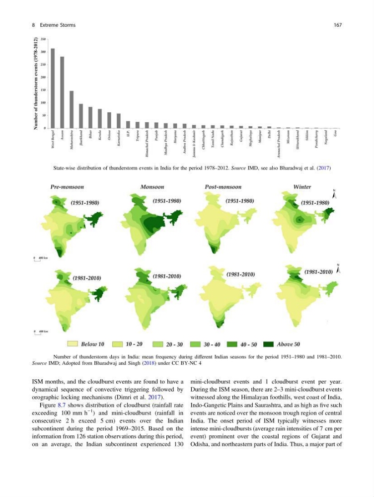
Fig. 8.5 State-wise distribution of thunderstorm events in India for the period 1978–2012. Source IMD, see also Bharadwaj et al. (2017)
Fig. 8.6 Number of thunderstorm days in India: mean frequency during different Indian seasons for the period 1951–1980 and 1981–2010.
Source IMD; Adopted from Bharadwaj and Singh (2018) under CC BY-NC 4
8 Extreme Storms
167
dynamical sequence of convective triggering followed by
orographic locking mechanisms (Dimri et al. 2017).
Figure 8.7 shows distribution of cloudburst (rainfall rate
exceeding 100 mm h
−1 ) and mini-cloudburst (rainfall in
consecutive 2 h exceed 5 cm) events over the Indian
subcontinent during the period 1969–2015. Based on the
information from 126 station observations during this period,
on an average, the Indian subcontinent experienced 130
mini-cloudburst events and 1 cloudburst event per year.
During the ISM season, there are 2–3 mini-cloudburst events
witnessed along the Himalayan foothills, west coast of India,
Indo-Gangetic Plains and Saurashtra, and as high as five such
events are noticed over the monsoon trough region of central
India. The onset period of ISM typically witnesses more
intense mini-cloudbursts (average rain intensities of 7 cm per
event) prominent over the coastal regions of Gujarat and
Odisha, and northeastern parts of India. Thus, a major part of
Fig. 8.5 State-wise distribution of thunderstorm events in India for the period 1978–2012. Source IMD, see also Bharadwaj et al. (2017)
Fig. 8.6 Number of thunderstorm days in India: mean frequency during different Indian seasons for the period 1951–1980 and 1981–2010.
Source IMD; Adopted from Bharadwaj and Singh (2018) under CC BY-NC 4
8 Extreme Storms
167