

7.5 Typical Technology
255
Safe Pixel
Points
Hazard
Pixel Points
R
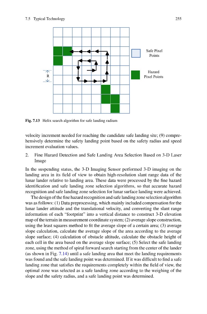
Fig. 7.13 Helix search algorithm for safe landing radium
velocity increment needed for reaching the candidate safe landing site; (9) comprehensively determine the safety landing point based on the safety radius and speed
increment evaluation values.
2. Fine Hazard Detection and Safe Landing Area Selection Based on 3-D Laser
Image
In the suspending status, the 3-D Imaging Sensor performed 3-D imaging on the
landing area in its field of view to obtain high-resolution slant range data of the
lunar lander relative to landing area. These data were processed by the fine hazard
identification and safe landing zone selection algorithms, so that accurate hazard
recognition and safe landing zone selection for lunar surface landing were achieved.
The design of the fine hazard recognition and safe landing zone selection algorithm
was as follows: (1) Data preprocessing, which mainly included compensation for the
lunar lander attitude and the translational velocity, and converting the slant range
information of each “footprint” into a vertical distance to construct 3-D elevation
map of the terrain in measurement coordinate system; (2) average slope construction,
using the least squares method to fit the average slope of a certain area; (3) average
slope calculation, calculate the average slope of the area according to the average
slope surface; (4) calculation of obstacle altitude, calculate the obstacle height of
each cell in the area based on the average slope surface; (5) Select the safe landing
zone, using the method of spiral forward search starting from the center of the lander
(as shown in Fig. 7.14) until a safe landing area that meet the landing requirements
was found and the safe landing point was determined. If it was difficult to find a safe
landing zone that satisfies the requirements completely within the field of view, the
optimal zone was selected as a safe landing zone according to the weighing of the
slope and the safety radius, and a safe landing point was determined.
255
Safe Pixel
Points
Hazard
Pixel Points
R
Fig. 7.13 Helix search algorithm for safe landing radium
velocity increment needed for reaching the candidate safe landing site; (9) comprehensively determine the safety landing point based on the safety radius and speed
increment evaluation values.
2. Fine Hazard Detection and Safe Landing Area Selection Based on 3-D Laser
Image
In the suspending status, the 3-D Imaging Sensor performed 3-D imaging on the
landing area in its field of view to obtain high-resolution slant range data of the
lunar lander relative to landing area. These data were processed by the fine hazard
identification and safe landing zone selection algorithms, so that accurate hazard
recognition and safe landing zone selection for lunar surface landing were achieved.
The design of the fine hazard recognition and safe landing zone selection algorithm
was as follows: (1) Data preprocessing, which mainly included compensation for the
lunar lander attitude and the translational velocity, and converting the slant range
information of each “footprint” into a vertical distance to construct 3-D elevation
map of the terrain in measurement coordinate system; (2) average slope construction,
using the least squares method to fit the average slope of a certain area; (3) average
slope calculation, calculate the average slope of the area according to the average
slope surface; (4) calculation of obstacle altitude, calculate the obstacle height of
each cell in the area based on the average slope surface; (5) Select the safe landing
zone, using the method of spiral forward search starting from the center of the lander
(as shown in Fig. 7.14) until a safe landing area that meet the landing requirements
was found and the safe landing point was determined. If it was difficult to find a safe
landing zone that satisfies the requirements completely within the field of view, the
optimal zone was selected as a safe landing zone according to the weighing of the
slope and the safety radius, and a safe landing point was determined.