

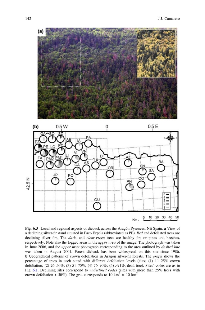
Fig. 6.3 Local and regional aspects of dieback across the Aragón Pyrenees, NE Spain. a View of
a declining silver-fir stand situated in Paco Ezpela (abbreviated as PE). Red and defoliated trees are
declining silver firs. The dark- and clear-green trees are healthy firs or pines and beeches,
respectively. Note also the logged areas in the upper area of the image. The photograph was taken
in June 2006, and the upper inset photograph corresponding to the area outlined by dashed line
was taken in August 2001. Forest dieback has been widespread on this site since 1986.
b Geographical patterns of crown defoliation in Aragón silver-fir forests. The graph shows the
percentage of trees in each stand with different defoliation levels (class (1) 11–25% crown
defoliation; (2) 26–50%; (3) 51–75%; (4) 76–90%; (5) >91%, dead tree). Sites’ codes are as in
Fig. 6.1. Declining sites correspond to underlined codes (sites with more than 25% trees with
crown defoliation > 50%). The grid corresponds to 10 km
2 Â 10 km
2
142
J.J. Camarero
a declining silver-fir stand situated in Paco Ezpela (abbreviated as PE). Red and defoliated trees are
declining silver firs. The dark- and clear-green trees are healthy firs or pines and beeches,
respectively. Note also the logged areas in the upper area of the image. The photograph was taken
in June 2006, and the upper inset photograph corresponding to the area outlined by dashed line
was taken in August 2001. Forest dieback has been widespread on this site since 1986.
b Geographical patterns of crown defoliation in Aragón silver-fir forests. The graph shows the
percentage of trees in each stand with different defoliation levels (class (1) 11–25% crown
defoliation; (2) 26–50%; (3) 51–75%; (4) 76–90%; (5) >91%, dead tree). Sites’ codes are as in
Fig. 6.1. Declining sites correspond to underlined codes (sites with more than 25% trees with
crown defoliation > 50%). The grid corresponds to 10 km
2 Â 10 km
2
142
J.J. Camarero