

3.3 Classifying the AQ Plans in Europe
The questionnaire responses have been classified trying to evaluate the level of
detail at which each block of the DPSIR scheme has been treated. Though this
classification is qualitative and partially subjective, it may serve a double purpose:
within each plan, it highlights were more work has been invested and where, on the
contrary, less attention was given; in comparison with other plans, it may indicate
how a certain aspect has been dealt with in similar cases.
It must be noted that dealing with an aspect with a higher level of detail does not
necessarily mean that the plan is more accurate or efficient in that field. Though the
two things are hopefully correlated, there may be cases in which a more detailed
approach was not supported by corresponding data or was not balanced with the
corresponding costs or benefits.
The analysis of individual AQPs has been summarized using radar charts. This
chart graphically represents the level of detail for each of the DPSIR blocks based
on the answers to the questionnaire. For each of the five blocks, five levels of detail
have been defined: Level 0—impossible to evaluate based on input from questionnaire (the topic is not even mentioned); Level 1—the block is considered in the
AQP, but not investigated; Level 2—low level of detail in the implementation;
Level 3—medium level of detail; and Level 4—high level of detail.
0%
5%
10%
15%
20%
25%
30%
35%
Emissions
Meteorology AQ Boundary
conditions
AQ Model
formulation
none
AQP (10 answers)
RP (25 answers)
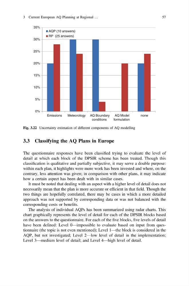
Fig. 3.22 Uncertainty estimation of different components of AQ modelling
3 Current European AQ Planning at Regional …
57
The questionnaire responses have been classified trying to evaluate the level of
detail at which each block of the DPSIR scheme has been treated. Though this
classification is qualitative and partially subjective, it may serve a double purpose:
within each plan, it highlights were more work has been invested and where, on the
contrary, less attention was given; in comparison with other plans, it may indicate
how a certain aspect has been dealt with in similar cases.
It must be noted that dealing with an aspect with a higher level of detail does not
necessarily mean that the plan is more accurate or efficient in that field. Though the
two things are hopefully correlated, there may be cases in which a more detailed
approach was not supported by corresponding data or was not balanced with the
corresponding costs or benefits.
The analysis of individual AQPs has been summarized using radar charts. This
chart graphically represents the level of detail for each of the DPSIR blocks based
on the answers to the questionnaire. For each of the five blocks, five levels of detail
have been defined: Level 0—impossible to evaluate based on input from questionnaire (the topic is not even mentioned); Level 1—the block is considered in the
AQP, but not investigated; Level 2—low level of detail in the implementation;
Level 3—medium level of detail; and Level 4—high level of detail.
0%
5%
10%
15%
20%
25%
30%
35%
Emissions
Meteorology AQ Boundary
conditions
AQ Model
formulation
none
AQP (10 answers)
RP (25 answers)
Fig. 3.22 Uncertainty estimation of different components of AQ modelling
3 Current European AQ Planning at Regional …
57