

76
4 Measuring Principles and Techniques …
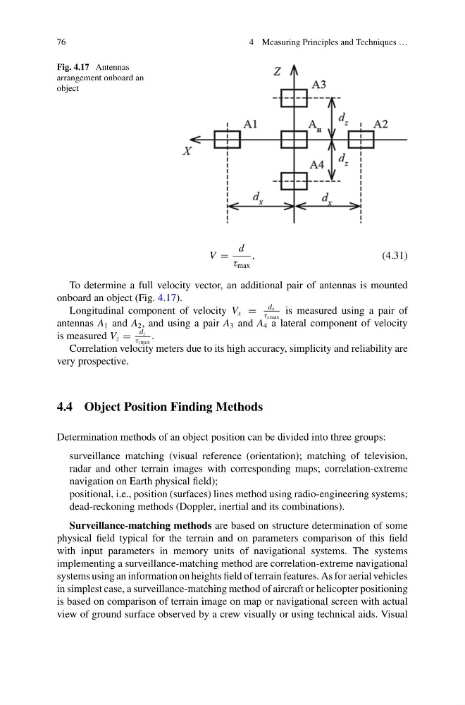
Fig. 4.17 Antennas
arrangement onboard an
object
V =
d
τ max
,
(4.31)
To determine a full velocity vector, an additional pair of antennas is mounted
onboard an object (Fig. 4.17).
Longitudinal component of velocity V x =
d x
τ xmax
is measured using a pair of
antennas A 1 and A 2 , and using a pair A 3 and A 4 a lateral component of velocity
is measured V z =
d z
τ zmax
.
Correlation velocity meters due to its high accuracy, simplicity and reliability are
very prospective.
4.4 Object Position Finding Methods
Determination methods of an object position can be divided into three groups:
surveillance matching (visual reference (orientation); matching of television,
radar and other terrain images with corresponding maps; correlation-extreme
navigation on Earth physical field);
positional, i.e., position (surfaces) lines method using radio-engineering systems;
dead-reckoning methods (Doppler, inertial and its combinations).
Surveillance-matching methods are based on structure determination of some
physical field typical for the terrain and on parameters comparison of this field
with input parameters in memory units of navigational systems. The systems
implementing a surveillance-matching method are correlation-extreme navigational
systems using an information on heights field of terrain features. As for aerial vehicles
in simplest case, a surveillance-matching method of aircraft or helicopter positioning
is based on comparison of terrain image on map or navigational screen with actual
view of ground surface observed by a crew visually or using technical aids. Visual
4 Measuring Principles and Techniques …
Fig. 4.17 Antennas
arrangement onboard an
object
V =
d
τ max
,
(4.31)
To determine a full velocity vector, an additional pair of antennas is mounted
onboard an object (Fig. 4.17).
Longitudinal component of velocity V x =
d x
τ xmax
is measured using a pair of
antennas A 1 and A 2 , and using a pair A 3 and A 4 a lateral component of velocity
is measured V z =
d z
τ zmax
.
Correlation velocity meters due to its high accuracy, simplicity and reliability are
very prospective.
4.4 Object Position Finding Methods
Determination methods of an object position can be divided into three groups:
surveillance matching (visual reference (orientation); matching of television,
radar and other terrain images with corresponding maps; correlation-extreme
navigation on Earth physical field);
positional, i.e., position (surfaces) lines method using radio-engineering systems;
dead-reckoning methods (Doppler, inertial and its combinations).
Surveillance-matching methods are based on structure determination of some
physical field typical for the terrain and on parameters comparison of this field
with input parameters in memory units of navigational systems. The systems
implementing a surveillance-matching method are correlation-extreme navigational
systems using an information on heights field of terrain features. As for aerial vehicles
in simplest case, a surveillance-matching method of aircraft or helicopter positioning
is based on comparison of terrain image on map or navigational screen with actual
view of ground surface observed by a crew visually or using technical aids. Visual