

268
14 Pseudo-Ranging Radio Navigation Systems
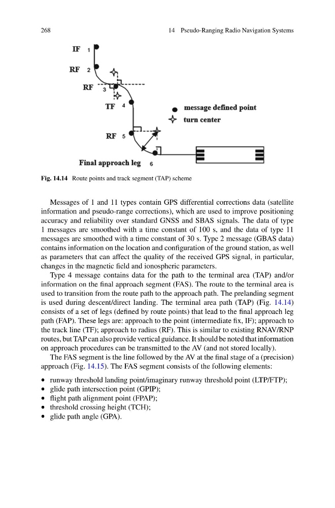
Fig. 14.14 Route points and track segment (TAP) scheme
Messages of 1 and 11 types contain GPS differential corrections data (satellite
information and pseudo-range corrections), which are used to improve positioning
accuracy and reliability over standard GNSS and SBAS signals. The data of type
1 messages are smoothed with a time constant of 100 s, and the data of type 11
messages are smoothed with a time constant of 30 s. Type 2 message (GBAS data)
contains information on the location and configuration of the ground station, as well
as parameters that can affect the quality of the received GPS signal, in particular,
changes in the magnetic field and ionospheric parameters.
Type 4 message contains data for the path to the terminal area (TAP) and/or
information on the final approach segment (FAS). The route to the terminal area is
used to transition from the route path to the approach path. The prelanding segment
is used during descent/direct landing. The terminal area path (TAP) (Fig. 14.14)
consists of a set of legs (defined by route points) that lead to the final approach leg
path (FAP). These legs are: approach to the point (intermediate fix, IF); approach to
the track line (TF); approach to radius (RF). This is similar to existing RNAV/RNP
routes, but TAP can also provide vertical guidance. It should be noted that information
on approach procedures can be transmitted to the AV (and not stored locally).
The FAS segment is the line followed by the AV at the final stage of a (precision)
approach (Fig. 14.15). The FAS segment consists of the following elements:
• runway threshold landing point/imaginary runway threshold point (LTP/FTP);
• glide path intersection point (GPIP);
• flight path alignment point (FPAP);
• threshold crossing height (TCH);
• glide path angle (GPA).
14 Pseudo-Ranging Radio Navigation Systems
Fig. 14.14 Route points and track segment (TAP) scheme
Messages of 1 and 11 types contain GPS differential corrections data (satellite
information and pseudo-range corrections), which are used to improve positioning
accuracy and reliability over standard GNSS and SBAS signals. The data of type
1 messages are smoothed with a time constant of 100 s, and the data of type 11
messages are smoothed with a time constant of 30 s. Type 2 message (GBAS data)
contains information on the location and configuration of the ground station, as well
as parameters that can affect the quality of the received GPS signal, in particular,
changes in the magnetic field and ionospheric parameters.
Type 4 message contains data for the path to the terminal area (TAP) and/or
information on the final approach segment (FAS). The route to the terminal area is
used to transition from the route path to the approach path. The prelanding segment
is used during descent/direct landing. The terminal area path (TAP) (Fig. 14.14)
consists of a set of legs (defined by route points) that lead to the final approach leg
path (FAP). These legs are: approach to the point (intermediate fix, IF); approach to
the track line (TF); approach to radius (RF). This is similar to existing RNAV/RNP
routes, but TAP can also provide vertical guidance. It should be noted that information
on approach procedures can be transmitted to the AV (and not stored locally).
The FAS segment is the line followed by the AV at the final stage of a (precision)
approach (Fig. 14.15). The FAS segment consists of the following elements:
• runway threshold landing point/imaginary runway threshold point (LTP/FTP);
• glide path intersection point (GPIP);
• flight path alignment point (FPAP);
• threshold crossing height (TCH);
• glide path angle (GPA).