

254
14 Pseudo-Ranging Radio Navigation Systems
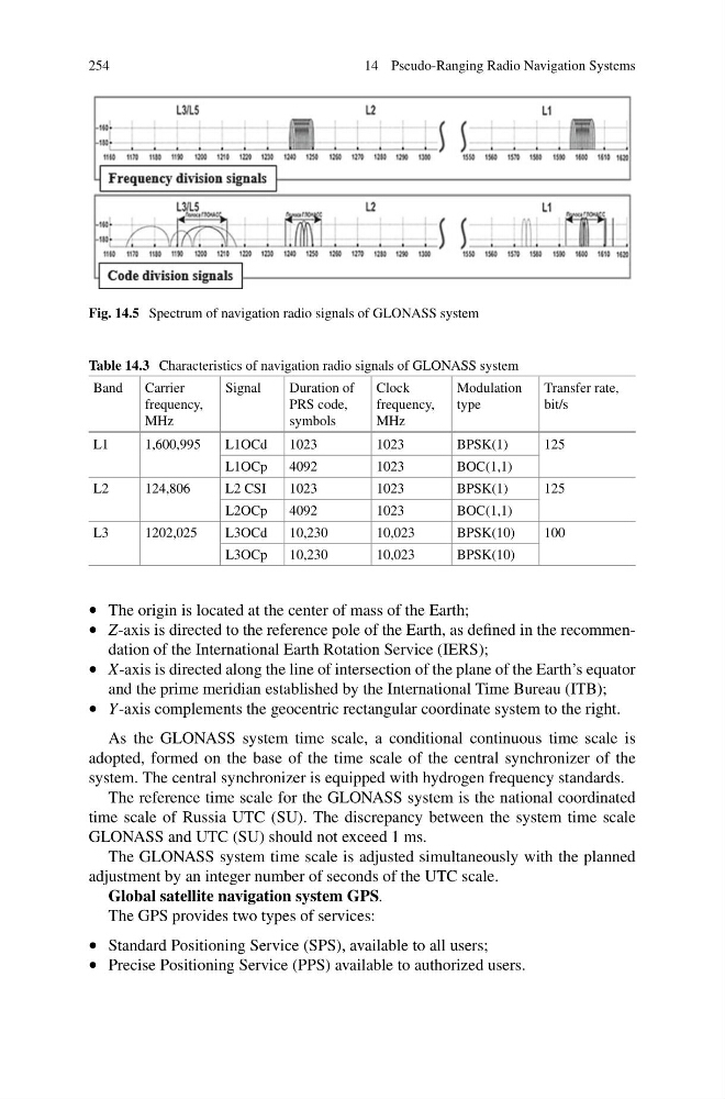
Fig. 14.5 Spectrum of navigation radio signals of GLONASS system
Table 14.3 Characteristics of navigation radio signals of GLONASS system
Band
Carrier
frequency,
MHz
Signal
Duration of
PRS code,
symbols
Clock
frequency,
MHz
Modulation
type
Transfer rate,
bit/s
L1
1,600,995
L1OCd
1023
1023
BPSK(1)
125
L1OCp
4092
1023
BOC(1,1)
L2
124,806
L2 CSI
1023
1023
BPSK(1)
125
L2OCp
4092
1023
BOC(1,1)
L3
1202,025
L3OCd
10,230
10,023
BPSK(10)
100
L3OCp
10,230
10,023
BPSK(10)
• The origin is located at the center of mass of the Earth;
• Z-axis is directed to the reference pole of the Earth, as defined in the recommendation of the International Earth Rotation Service (IERS);
• X-axis is directed along the line of intersection of the plane of the Earth’s equator
and the prime meridian established by the International Time Bureau (ITB);
• Y-axis complements the geocentric rectangular coordinate system to the right.
As the GLONASS system time scale, a conditional continuous time scale is
adopted, formed on the base of the time scale of the central synchronizer of the
system. The central synchronizer is equipped with hydrogen frequency standards.
The reference time scale for the GLONASS system is the national coordinated
time scale of Russia UTC (SU). The discrepancy between the system time scale
GLONASS and UTC (SU) should not exceed 1 ms.
The GLONASS system time scale is adjusted simultaneously with the planned
adjustment by an integer number of seconds of the UTC scale.
Global satellite navigation system GPS.
The GPS provides two types of services:
• Standard Positioning Service (SPS), available to all users;
• Precise Positioning Service (PPS) available to authorized users.
14 Pseudo-Ranging Radio Navigation Systems
Fig. 14.5 Spectrum of navigation radio signals of GLONASS system
Table 14.3 Characteristics of navigation radio signals of GLONASS system
Band
Carrier
frequency,
MHz
Signal
Duration of
PRS code,
symbols
Clock
frequency,
MHz
Modulation
type
Transfer rate,
bit/s
L1
1,600,995
L1OCd
1023
1023
BPSK(1)
125
L1OCp
4092
1023
BOC(1,1)
L2
124,806
L2 CSI
1023
1023
BPSK(1)
125
L2OCp
4092
1023
BOC(1,1)
L3
1202,025
L3OCd
10,230
10,023
BPSK(10)
100
L3OCp
10,230
10,023
BPSK(10)
• The origin is located at the center of mass of the Earth;
• Z-axis is directed to the reference pole of the Earth, as defined in the recommendation of the International Earth Rotation Service (IERS);
• X-axis is directed along the line of intersection of the plane of the Earth’s equator
and the prime meridian established by the International Time Bureau (ITB);
• Y-axis complements the geocentric rectangular coordinate system to the right.
As the GLONASS system time scale, a conditional continuous time scale is
adopted, formed on the base of the time scale of the central synchronizer of the
system. The central synchronizer is equipped with hydrogen frequency standards.
The reference time scale for the GLONASS system is the national coordinated
time scale of Russia UTC (SU). The discrepancy between the system time scale
GLONASS and UTC (SU) should not exceed 1 ms.
The GLONASS system time scale is adjusted simultaneously with the planned
adjustment by an integer number of seconds of the UTC scale.
Global satellite navigation system GPS.
The GPS provides two types of services:
• Standard Positioning Service (SPS), available to all users;
• Precise Positioning Service (PPS) available to authorized users.