

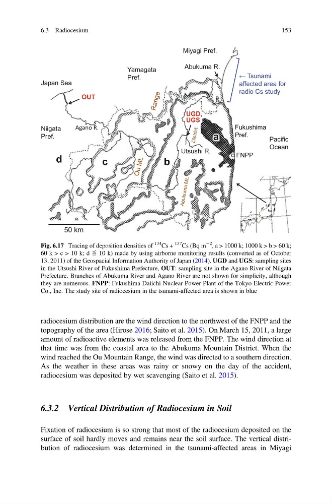
radiocesium distribution are the wind direction to the northwest of the FNPP and the
topography of the area (Hirose 2016; Saito et al. 2015). On March 15, 2011, a large
amount of radioactive elements was released from the FNPP. The wind direction at
that time was from the coastal area to the Abukuma Mountain District. When the
wind reached the Ou Mountain Range, the wind was directed to a southern direction.
As the weather in these areas was rainy or snowy on the day of the accident,
radiocesium was deposited by wet scavenging (Saito et al. 2015).
6.3.2 Vertical Distribution of Radiocesium in Soil
Fixation of radiocesium is so strong that most of the radiocesium deposited on the
surface of soil hardly moves and remains near the soil surface. The vertical distribution of radiocesium was determined in the tsunami-affected areas in Miyagi
FNPP
Agano R.
Pacific
Ocean
Abukuma R.
Japan Sea
OUT
UGD,
UGS
b
c
d
a
Utsushi R.
50 km
Miyagi Pref.
Niigata
Pref.
Yamagata
Pref.
Fukushima
Pref.
← Tsunami
affected area for
radio Cs study
Fig. 6.17 Tracing of deposition densities of
134 Cs +
137
Cs (Bq m
À2
, a > 1000 k; 1000 k > b > 60 k;
60 k > c > 10 k; d ≦ 10 k) made by using airborne monitoring results (converted as of October
13, 2011) of the Geospacial Information Authority of Japan (2014). UGD and UGS: sampling sites
in the Utsushi River of Fukushima Prefecture, OUT: sampling site in the Agano River of Niigata
Prefecture. Branches of Abukuma River and Agano River are not shown for simplicity, although
they are numerous. FNPP: Fukushima Daiichi Nuclear Power Plant of the Tokyo Electric Power
Co., Inc. The study site of radiocesium in the tsunami-affected area is shown in blue
6.3 Radiocesium
153
topography of the area (Hirose 2016; Saito et al. 2015). On March 15, 2011, a large
amount of radioactive elements was released from the FNPP. The wind direction at
that time was from the coastal area to the Abukuma Mountain District. When the
wind reached the Ou Mountain Range, the wind was directed to a southern direction.
As the weather in these areas was rainy or snowy on the day of the accident,
radiocesium was deposited by wet scavenging (Saito et al. 2015).
6.3.2 Vertical Distribution of Radiocesium in Soil
Fixation of radiocesium is so strong that most of the radiocesium deposited on the
surface of soil hardly moves and remains near the soil surface. The vertical distribution of radiocesium was determined in the tsunami-affected areas in Miyagi
FNPP
Agano R.
Pacific
Ocean
Abukuma R.
Japan Sea
OUT
UGD,
UGS
b
c
d
a
Utsushi R.
50 km
Miyagi Pref.
Niigata
Pref.
Yamagata
Pref.
Fukushima
Pref.
← Tsunami
affected area for
radio Cs study
Fig. 6.17 Tracing of deposition densities of
134 Cs +
137
Cs (Bq m
À2
, a > 1000 k; 1000 k > b > 60 k;
60 k > c > 10 k; d ≦ 10 k) made by using airborne monitoring results (converted as of October
13, 2011) of the Geospacial Information Authority of Japan (2014). UGD and UGS: sampling sites
in the Utsushi River of Fukushima Prefecture, OUT: sampling site in the Agano River of Niigata
Prefecture. Branches of Abukuma River and Agano River are not shown for simplicity, although
they are numerous. FNPP: Fukushima Daiichi Nuclear Power Plant of the Tokyo Electric Power
Co., Inc. The study site of radiocesium in the tsunami-affected area is shown in blue
6.3 Radiocesium
153