

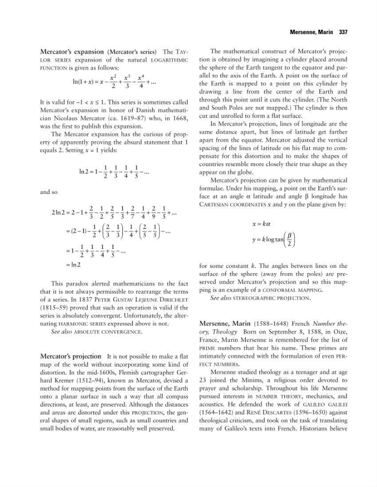
Mercator’s expansion (Mercator’s series) The TAYLOR SERIES expansion of the natural LOGARITHMIC
FUNCTION is given as follows:
It is valid for –1 < x ≤ 1. This series is sometimes called
Mercator’s expansion in honor of Danish mathematician Nicolaus Mercator (ca. 1619–87) who, in 1668,
was the first to publish this expansion.
The Mercator expansion has the curious of property of apparently proving the absurd statement that 1
equals 2. Setting x = 1 yields:
and so
This paradox alerted mathematicians to the fact
that it is not always permissible to rearrange the terms
of a series. In 1837 PETER GUSTAV LEJEUNE DIRICHLET
(1815–59) proved that such an operation is valid if the
series is absolutely convergent. Unfortunately, the alternating HARMONIC SERIES expressed above is not.
See also ABSOLUTE CONVERGENCE.
Mercator’s projection It is not possible to make a flat
map of the world without incorporating some kind of
distortion. In the mid-1600s, Flemish cartographer Gerhard Kremer (1512–94), known as Mercator, devised a
method for mapping points from the surface of the Earth
onto a planar surface in such a way that all compass
directions, at least, are preserved. Although the distances
and areas are distorted under this PROJECTION, the general shapes of small regions, such as small countries and
small bodies of water, are reasonably well preserved.
The mathematical construct of Mercator’s projection is obtained by imagining a cylinder placed around
the sphere of the Earth tangent to the equator and parallel to the axis of the Earth. A point on the surface of
the Earth is mapped to a point on this cylinder by
drawing a line from the center of the Earth and
through this point until it cuts the cylinder. (The North
and South Poles are not mapped.) The cylinder is then
cut and unrolled to form a flat surface.
In Mercator’s projection, lines of longitude are the
same distance apart, but lines of latitude get farther
apart from the equator. Mercator adjusted the vertical
spacing of the lines of latitude on his flat map to compensate for this distortion and to make the shapes of
countries resemble more closely their true shape as they
appear on the globe.
Mercator’s projection can be given by mathematical
formulae. Under his mapping, a point on the Earth’s surface at an angle α latitude and angle β longitude has
CARTESIAN COORDINATES x and y on the plane given by:
for some constant k. The angles between lines on the
surface of the sphere (away from the poles) are preserved under Mercator’s projection and so this mapping is an example of a CONFORMAL MAPPING.
See also STEREOGRAPHIC PROJECTION.
Mersenne, Marin (1588–1648) French Number theory, Theology Born on September 8, 1588, in Oize,
France, Marin Mersenne is remembered for the list of
PRIME numbers that bear his name. These primes are
intimately connected with the formulation of even PERFECT NUMBERs.
Mersenne studied theology as a teenager and at age
23 joined the Minims, a religious order devoted to
prayer and scholarship. Throughout his life Mersenne
pursued interests in NUMBER THEORY, mechanics, and
acoustics. He defended the work of GALILEO GALILEI
(1564–1642) and RENÉ DESCARTES (1596–1650) against
theological criticism, and took on the task of translating
many of Galileo’s texts into French. Historians believe
x k
y k
=
=
α
β
log tan 2
2 2 2 1
2
3
1
2
2
5
1
3
2
7
1
4
2
9
1
5
2 1
1
2
2
3
1
3
1
4
2
5
1
5
1
1
2
1
3
1
4
1
5
2
ln
...
(
)
...
...
ln
= − + − + − + − + − +
= − − +
−
− +
−
−
= − + − + −
=
ln
...
2 1
1
2
1
3
1
4
1
5
= − + − + −
ln(
)
...
1
2
3
4
2
3
4
+ = −
+
−
+
x x
x
x
x
Mersenne, Marin 337
FUNCTION is given as follows:
It is valid for –1 < x ≤ 1. This series is sometimes called
Mercator’s expansion in honor of Danish mathematician Nicolaus Mercator (ca. 1619–87) who, in 1668,
was the first to publish this expansion.
The Mercator expansion has the curious of property of apparently proving the absurd statement that 1
equals 2. Setting x = 1 yields:
and so
This paradox alerted mathematicians to the fact
that it is not always permissible to rearrange the terms
of a series. In 1837 PETER GUSTAV LEJEUNE DIRICHLET
(1815–59) proved that such an operation is valid if the
series is absolutely convergent. Unfortunately, the alternating HARMONIC SERIES expressed above is not.
See also ABSOLUTE CONVERGENCE.
Mercator’s projection It is not possible to make a flat
map of the world without incorporating some kind of
distortion. In the mid-1600s, Flemish cartographer Gerhard Kremer (1512–94), known as Mercator, devised a
method for mapping points from the surface of the Earth
onto a planar surface in such a way that all compass
directions, at least, are preserved. Although the distances
and areas are distorted under this PROJECTION, the general shapes of small regions, such as small countries and
small bodies of water, are reasonably well preserved.
The mathematical construct of Mercator’s projection is obtained by imagining a cylinder placed around
the sphere of the Earth tangent to the equator and parallel to the axis of the Earth. A point on the surface of
the Earth is mapped to a point on this cylinder by
drawing a line from the center of the Earth and
through this point until it cuts the cylinder. (The North
and South Poles are not mapped.) The cylinder is then
cut and unrolled to form a flat surface.
In Mercator’s projection, lines of longitude are the
same distance apart, but lines of latitude get farther
apart from the equator. Mercator adjusted the vertical
spacing of the lines of latitude on his flat map to compensate for this distortion and to make the shapes of
countries resemble more closely their true shape as they
appear on the globe.
Mercator’s projection can be given by mathematical
formulae. Under his mapping, a point on the Earth’s surface at an angle α latitude and angle β longitude has
CARTESIAN COORDINATES x and y on the plane given by:
for some constant k. The angles between lines on the
surface of the sphere (away from the poles) are preserved under Mercator’s projection and so this mapping is an example of a CONFORMAL MAPPING.
See also STEREOGRAPHIC PROJECTION.
Mersenne, Marin (1588–1648) French Number theory, Theology Born on September 8, 1588, in Oize,
France, Marin Mersenne is remembered for the list of
PRIME numbers that bear his name. These primes are
intimately connected with the formulation of even PERFECT NUMBERs.
Mersenne studied theology as a teenager and at age
23 joined the Minims, a religious order devoted to
prayer and scholarship. Throughout his life Mersenne
pursued interests in NUMBER THEORY, mechanics, and
acoustics. He defended the work of GALILEO GALILEI
(1564–1642) and RENÉ DESCARTES (1596–1650) against
theological criticism, and took on the task of translating
many of Galileo’s texts into French. Historians believe
x k
y k
=
=
α
β
log tan 2
2 2 2 1
2
3
1
2
2
5
1
3
2
7
1
4
2
9
1
5
2 1
1
2
2
3
1
3
1
4
2
5
1
5
1
1
2
1
3
1
4
1
5
2
ln
...
(
)
...
...
ln
= − + − + − + − + − +
= − − +
−
− +
−
−
= − + − + −
=
ln
...
2 1
1
2
1
3
1
4
1
5
= − + − + −
ln(
)
...
1
2
3
4
2
3
4
+ = −
+
−
+
x x
x
x
x
Mersenne, Marin 337