

Perspectives of Climate Change Adaptation in Organizations …
331
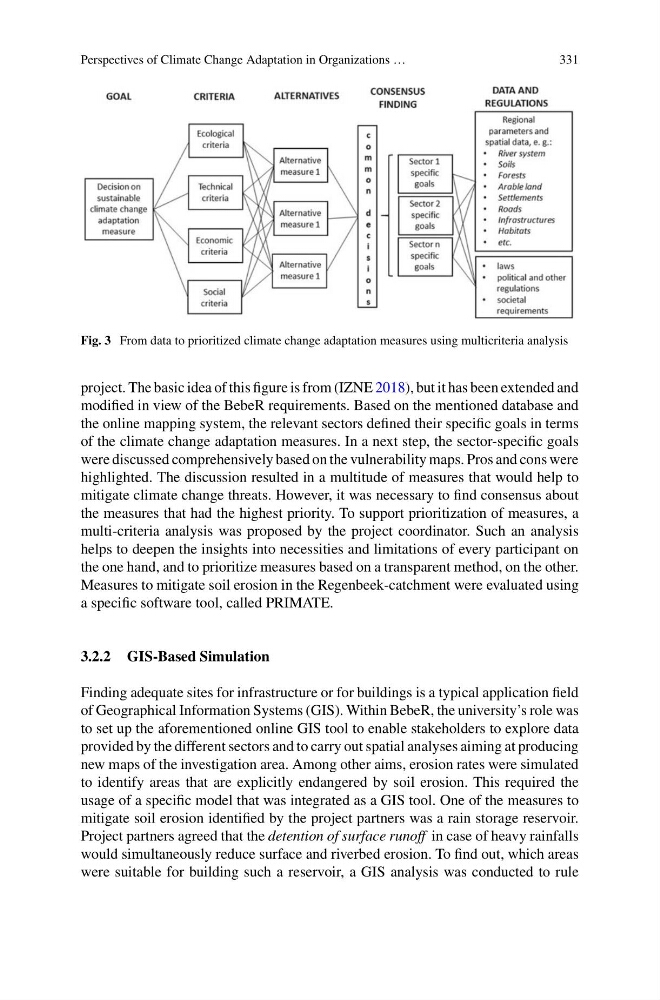
Fig. 3 From data to prioritized climate change adaptation measures using multicriteria analysis
project. The basic idea of this figure is from (IZNE 2018), but it has been extended and
modified in view of the BebeR requirements. Based on the mentioned database and
the online mapping system, the relevant sectors defined their specific goals in terms
of the climate change adaptation measures. In a next step, the sector-specific goals
were discussed comprehensively based on the vulnerability maps. Pros and cons were
highlighted. The discussion resulted in a multitude of measures that would help to
mitigate climate change threats. However, it was necessary to find consensus about
the measures that had the highest priority. To support prioritization of measures, a
multi-criteria analysis was proposed by the project coordinator. Such an analysis
helps to deepen the insights into necessities and limitations of every participant on
the one hand, and to prioritize measures based on a transparent method, on the other.
Measures to mitigate soil erosion in the Regenbeek-catchment were evaluated using
a specific software tool, called PRIMATE.
3.2.2 GIS-Based Simulation
Finding adequate sites for infrastructure or for buildings is a typical application field
of Geographical Information Systems (GIS). Within BebeR, the university’s role was
to set up the aforementioned online GIS tool to enable stakeholders to explore data
provided by the different sectors and to carry out spatial analyses aiming at producing
new maps of the investigation area. Among other aims, erosion rates were simulated
to identify areas that are explicitly endangered by soil erosion. This required the
usage of a specific model that was integrated as a GIS tool. One of the measures to
mitigate soil erosion identified by the project partners was a rain storage reservoir.
Project partners agreed that the detention of surface runoff in case of heavy rainfalls
would simultaneously reduce surface and riverbed erosion. To find out, which areas
were suitable for building such a reservoir, a GIS analysis was conducted to rule
331
Fig. 3 From data to prioritized climate change adaptation measures using multicriteria analysis
project. The basic idea of this figure is from (IZNE 2018), but it has been extended and
modified in view of the BebeR requirements. Based on the mentioned database and
the online mapping system, the relevant sectors defined their specific goals in terms
of the climate change adaptation measures. In a next step, the sector-specific goals
were discussed comprehensively based on the vulnerability maps. Pros and cons were
highlighted. The discussion resulted in a multitude of measures that would help to
mitigate climate change threats. However, it was necessary to find consensus about
the measures that had the highest priority. To support prioritization of measures, a
multi-criteria analysis was proposed by the project coordinator. Such an analysis
helps to deepen the insights into necessities and limitations of every participant on
the one hand, and to prioritize measures based on a transparent method, on the other.
Measures to mitigate soil erosion in the Regenbeek-catchment were evaluated using
a specific software tool, called PRIMATE.
3.2.2 GIS-Based Simulation
Finding adequate sites for infrastructure or for buildings is a typical application field
of Geographical Information Systems (GIS). Within BebeR, the university’s role was
to set up the aforementioned online GIS tool to enable stakeholders to explore data
provided by the different sectors and to carry out spatial analyses aiming at producing
new maps of the investigation area. Among other aims, erosion rates were simulated
to identify areas that are explicitly endangered by soil erosion. This required the
usage of a specific model that was integrated as a GIS tool. One of the measures to
mitigate soil erosion identified by the project partners was a rain storage reservoir.
Project partners agreed that the detention of surface runoff in case of heavy rainfalls
would simultaneously reduce surface and riverbed erosion. To find out, which areas
were suitable for building such a reservoir, a GIS analysis was conducted to rule