

264
K. S. Gemail et al.
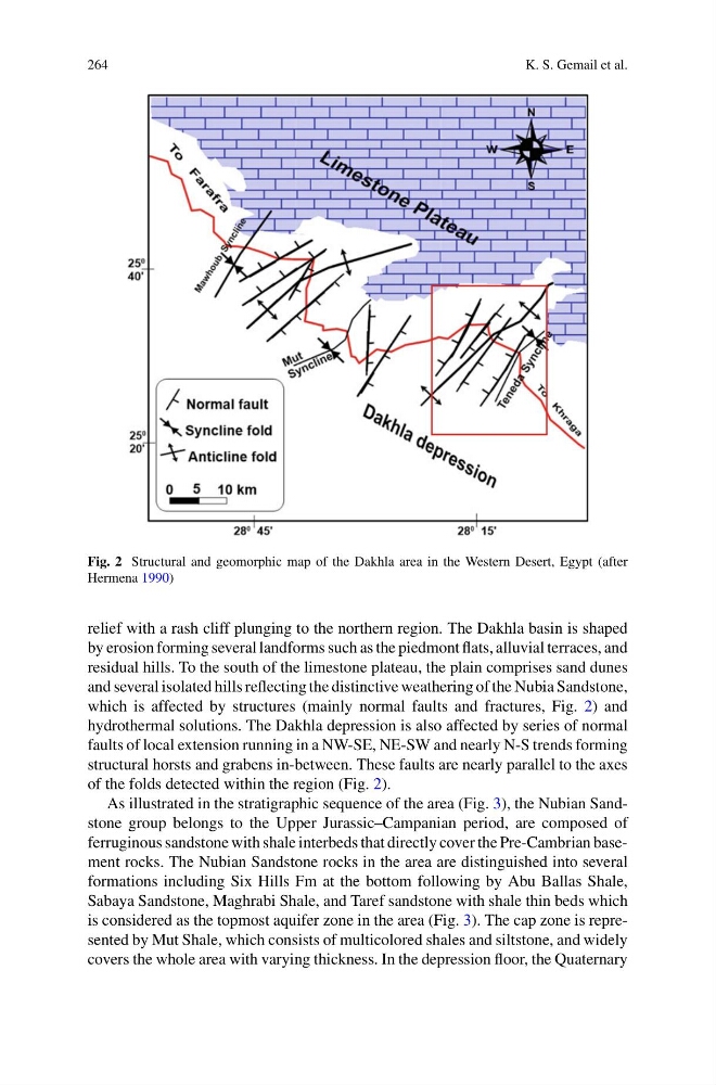
Fig. 2 Structural and geomorphic map of the Dakhla area in the Western Desert, Egypt (after
Hermena 1990)
relief with a rash cliff plunging to the northern region. The Dakhla basin is shaped
by erosion forming several landforms such as the piedmont flats, alluvial terraces, and
residual hills. To the south of the limestone plateau, the plain comprises sand dunes
and several isolated hills reflecting the distinctive weathering of the Nubia Sandstone,
which is affected by structures (mainly normal faults and fractures, Fig. 2) and
hydrothermal solutions. The Dakhla depression is also affected by series of normal
faults of local extension running in a NW-SE, NE-SW and nearly N-S trends forming
structural horsts and grabens in-between. These faults are nearly parallel to the axes
of the folds detected within the region (Fig. 2).
As illustrated in the stratigraphic sequence of the area (Fig. 3), the Nubian Sandstone group belongs to the Upper Jurassic–Campanian period, are composed of
ferruginous sandstone with shale interbeds that directly cover the Pre-Cambrian basement rocks. The Nubian Sandstone rocks in the area are distinguished into several
formations including Six Hills Fm at the bottom following by Abu Ballas Shale,
Sabaya Sandstone, Maghrabi Shale, and Taref sandstone with shale thin beds which
is considered as the topmost aquifer zone in the area (Fig. 3). The cap zone is represented by Mut Shale, which consists of multicolored shales and siltstone, and widely
covers the whole area with varying thickness. In the depression floor, the Quaternary
K. S. Gemail et al.
Fig. 2 Structural and geomorphic map of the Dakhla area in the Western Desert, Egypt (after
Hermena 1990)
relief with a rash cliff plunging to the northern region. The Dakhla basin is shaped
by erosion forming several landforms such as the piedmont flats, alluvial terraces, and
residual hills. To the south of the limestone plateau, the plain comprises sand dunes
and several isolated hills reflecting the distinctive weathering of the Nubia Sandstone,
which is affected by structures (mainly normal faults and fractures, Fig. 2) and
hydrothermal solutions. The Dakhla depression is also affected by series of normal
faults of local extension running in a NW-SE, NE-SW and nearly N-S trends forming
structural horsts and grabens in-between. These faults are nearly parallel to the axes
of the folds detected within the region (Fig. 2).
As illustrated in the stratigraphic sequence of the area (Fig. 3), the Nubian Sandstone group belongs to the Upper Jurassic–Campanian period, are composed of
ferruginous sandstone with shale interbeds that directly cover the Pre-Cambrian basement rocks. The Nubian Sandstone rocks in the area are distinguished into several
formations including Six Hills Fm at the bottom following by Abu Ballas Shale,
Sabaya Sandstone, Maghrabi Shale, and Taref sandstone with shale thin beds which
is considered as the topmost aquifer zone in the area (Fig. 3). The cap zone is represented by Mut Shale, which consists of multicolored shales and siltstone, and widely
covers the whole area with varying thickness. In the depression floor, the Quaternary