

128
A. B. A. Belal et al.
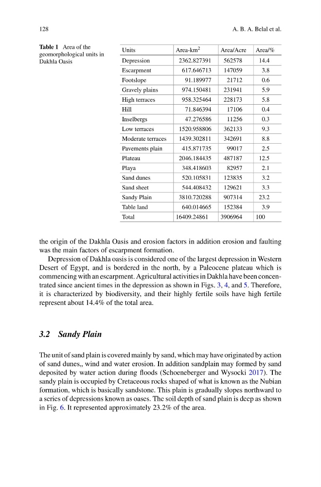
Table 1 Area of the
geomorphological units in
Dakhla Oasis
Units
Area-km 2
Area/Acre
Area/%
Depression
2362.827391
562578
14.4
Escarpment
617.646713
147059
3.8
Footslope
91.189977
21712
0.6
Gravely plains
974.150481
231941
5.9
High terraces
958.325464
228173
5.8
Hill
71.846394
17106
0.4
Inselbergs
47.276586
11256
0.3
Low terraces
1520.958806
362133
9.3
Moderate terraces
1439.302811
342691
8.8
Pavements plain
415.871735
99017
2.5
Plateau
2046.184435
487187
12.5
Playa
348.418603
82957
2.1
Sand dunes
520.105831
123835
3.2
Sand sheet
544.408432
129621
3.3
Sandy Plain
3810.720288
907314
23.2
Table land
640.014665
152384
3.9
Total
16409.24861
3906964
100
the origin of the Dakhla Oasis and erosion factors in addition erosion and faulting
was the main factors of escarpment formation.
Depression of Dakhla oasis is considered one of the largest depression in Western
Desert of Egypt, and is bordered in the north, by a Paleocene plateau which is
commencing with an escarpment. Agricultural activities in Dakhla have been concentrated since ancient times in the depression as shown in Figs. 3, 4, and 5. Therefore,
it is characterized by biodiversity, and their highly fertile soils have high fertile
represent about 14.4% of the total area.
3.2 Sandy Plain
The unit of sand plain is covered mainly by sand, which may have originated by action
of sand dunes„ wind and water erosion. In addition sandplain may formed by sand
deposited by water action during floods (Schoeneberger and Wysocki 2017). The
sandy plain is occupied by Cretaceous rocks shaped of what is known as the Nubian
formation, which is basically sandstone. This plain is gradually slopes northward to
a series of depressions known as oases. The soil depth of sand plain is deep as shown
in Fig. 6. It represented approximately 23.2% of the area.
A. B. A. Belal et al.
Table 1 Area of the
geomorphological units in
Dakhla Oasis
Units
Area-km 2
Area/Acre
Area/%
Depression
2362.827391
562578
14.4
Escarpment
617.646713
147059
3.8
Footslope
91.189977
21712
0.6
Gravely plains
974.150481
231941
5.9
High terraces
958.325464
228173
5.8
Hill
71.846394
17106
0.4
Inselbergs
47.276586
11256
0.3
Low terraces
1520.958806
362133
9.3
Moderate terraces
1439.302811
342691
8.8
Pavements plain
415.871735
99017
2.5
Plateau
2046.184435
487187
12.5
Playa
348.418603
82957
2.1
Sand dunes
520.105831
123835
3.2
Sand sheet
544.408432
129621
3.3
Sandy Plain
3810.720288
907314
23.2
Table land
640.014665
152384
3.9
Total
16409.24861
3906964
100
the origin of the Dakhla Oasis and erosion factors in addition erosion and faulting
was the main factors of escarpment formation.
Depression of Dakhla oasis is considered one of the largest depression in Western
Desert of Egypt, and is bordered in the north, by a Paleocene plateau which is
commencing with an escarpment. Agricultural activities in Dakhla have been concentrated since ancient times in the depression as shown in Figs. 3, 4, and 5. Therefore,
it is characterized by biodiversity, and their highly fertile soils have high fertile
represent about 14.4% of the total area.
3.2 Sandy Plain
The unit of sand plain is covered mainly by sand, which may have originated by action
of sand dunes„ wind and water erosion. In addition sandplain may formed by sand
deposited by water action during floods (Schoeneberger and Wysocki 2017). The
sandy plain is occupied by Cretaceous rocks shaped of what is known as the Nubian
formation, which is basically sandstone. This plain is gradually slopes northward to
a series of depressions known as oases. The soil depth of sand plain is deep as shown
in Fig. 6. It represented approximately 23.2% of the area.